Remote sensing in agricultural engineering enables the collection of extensive crop and soil data via satellite or drone imagery, providing timely and large-scale monitoring of plant health, moisture levels, and pest infestations. Ground sensing complements this by offering precise, localized measurements through sensors and manual sampling, enhancing accuracy for soil nutrient analysis and specific crop condition assessments. Combining remote and ground sensing technologies optimizes farm management decisions, improving crop yield predictions and resource efficiency.
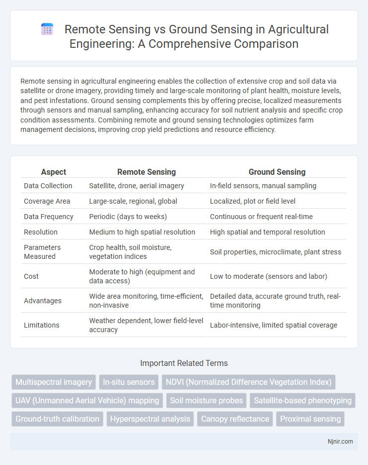
Table of Comparison
| Aspect | Remote Sensing | Ground Sensing |
|---|---|---|
| Data Collection | Satellite, drone, aerial imagery | In-field sensors, manual sampling |
| Coverage Area | Large-scale, regional, global | Localized, plot or field level |
| Data Frequency | Periodic (days to weeks) | Continuous or frequent real-time |
| Resolution | Medium to high spatial resolution | High spatial and temporal resolution |
| Parameters Measured | Crop health, soil moisture, vegetation indices | Soil properties, microclimate, plant stress |
| Cost | Moderate to high (equipment and data access) | Low to moderate (sensors and labor) |
| Advantages | Wide area monitoring, time-efficient, non-invasive | Detailed data, accurate ground truth, real-time monitoring |
| Limitations | Weather dependent, lower field-level accuracy | Labor-intensive, limited spatial coverage |
Introduction to Sensing Technologies in Agriculture
Remote sensing technology in agriculture uses satellite or aerial sensor technologies to collect data on crop health, soil conditions, and weather patterns from a distance, enabling large-scale monitoring and precision farming. Ground sensing involves in-field devices such as soil moisture sensors, weather stations, and handheld spectrometers, providing real-time, localized measurements crucial for immediate decision-making. Integrating remote sensing with ground sensing technologies enhances accuracy in data collection, promotes sustainable resource management, and improves crop yield predictions.
Overview of Remote Sensing
Remote sensing involves collecting data about Earth's surface from satellites or aircraft, enabling large-scale environmental monitoring without direct contact. Sensors capture electromagnetic signals reflected or emitted by objects, providing valuable information for mapping land use, vegetation health, and climate change analysis. This technology offers efficient, repeatable, and extensive data acquisition compared to ground sensing, which relies on localized measurements from physical instruments on-site.
Ground Sensing: Principles and Applications
Ground sensing involves direct measurement of environmental parameters using in-situ instruments like soil moisture probes, weather stations, and ground-penetrating radar, providing high accuracy and spatial specificity. It enables detailed analysis of soil composition, vegetation health, and microclimate conditions essential for precision agriculture, forestry management, and environmental monitoring. Key applications leverage its ability to calibrate and validate remote sensing data, enhancing the reliability of large-scale spatial analyses.
Data Collection Methods: Satellite, Drone, and In-Field Sensors
Satellite remote sensing captures extensive data through multispectral and hyperspectral imaging, enabling large-scale environmental monitoring with high temporal resolution. Drone-based remote sensing offers flexible, high-resolution data collection ideal for targeted areas, utilizing RGB, thermal, and LiDAR sensors for detailed spatial analysis. Ground sensing relies on in-field sensors like soil moisture probes, weather stations, and handheld spectrometers, providing precise, localized measurements that complement remote sensing by validating and calibrating aerial data.
Spatial Resolution: Comparing Remote and Ground Sensing
Remote sensing typically offers broader spatial coverage with spatial resolutions ranging from meters to kilometers, enabling large-scale environmental monitoring. Ground sensing provides finer spatial resolution at the centimeter or millimeter scale, allowing detailed observations of localized phenomena. The choice between remote and ground sensing depends on the required spatial resolution for specific applications like precision agriculture or regional climate studies.
Accuracy and Reliability in Agricultural Monitoring
Remote sensing in agricultural monitoring offers broad spatial coverage and timely data acquisition but may face challenges in accuracy due to atmospheric interference and sensor limitations. Ground sensing provides highly accurate and reliable measurements through direct soil and crop assessment, though its spatial scope is limited and labor-intensive. Integrating both approaches enhances overall monitoring accuracy and reliability, combining the extensive reach of remote sensing with the precise detail of ground sensing.
Cost Analysis: Investment and Operational Expenses
Remote sensing requires significant initial investment in satellite or aerial equipment but offers lower operational costs due to automated data collection over large areas. Ground sensing involves lower upfront costs but higher ongoing expenses related to manpower, maintenance, and localized sensor deployment. For large-scale or inaccessible regions, remote sensing proves more cost-effective, while ground sensing is economically viable for precise, localized monitoring.
Integration of Remote and Ground Sensing Systems
Integrating remote sensing and ground sensing systems enhances precision in environmental monitoring by combining satellite or aerial imagery with localized sensor data. This fusion facilitates comprehensive data analysis, improving accuracy in applications such as agriculture, disaster management, and urban planning. Leveraging both spatial coverage from remote sensing and detailed ground-level information yields robust insights for informed decision-making.
Applications in Precision Agriculture
Remote sensing employs satellite or drone imagery to monitor crop health, soil moisture, and nutrient levels over large agricultural fields, enabling efficient resource management and early pest detection. Ground sensing uses soil probes, handheld sensors, and weather stations to provide precise, real-time data on microclimate conditions and plant physiology, supporting targeted interventions like variable rate fertilization. Integrating remote sensing with ground sensing enhances precision agriculture by combining spatial coverage with localized accuracy, increasing yield and reducing environmental impact.
Future Trends and Innovations in Sensing Technologies
Advancements in remote sensing technologies are increasingly integrating AI-driven data analytics and hyperspectral imaging, enabling more precise environmental monitoring across vast terrains. Ground sensing innovations focus on deploying miniaturized, energy-efficient sensor networks with real-time data transmission, enhancing localized insights in agriculture and urban planning. Emerging trends emphasize the fusion of remote and ground sensing data for comprehensive spatial analysis, leveraging IoT and cloud computing to drive smarter decision-making and predictive modeling.
Multispectral imagery
Multispectral imagery in remote sensing provides broad spatial coverage and diverse spectral data compared to ground sensing, enabling efficient analysis of land cover, vegetation health, and environmental changes over large areas.
In-situ sensors
In-situ sensors provide precise, real-time data directly from the environment, enhancing the accuracy of remote sensing by validating satellite and airborne observations.
NDVI (Normalized Difference Vegetation Index)
Remote sensing provides large-scale NDVI data to monitor vegetation health efficiently, whereas ground sensing offers precise, localized NDVI measurements critical for validation and detailed analysis.
UAV (Unmanned Aerial Vehicle) mapping
UAV mapping enhances remote sensing accuracy by providing high-resolution, real-time aerial data that complements detailed ground sensing measurements for precise environmental monitoring.
Soil moisture probes
Soil moisture probes in ground sensing provide high-accuracy, localized soil moisture data, whereas remote sensing offers broader spatial coverage but with lower resolution and indirect measurements.
Satellite-based phenotyping
Satellite-based phenotyping in remote sensing offers high-resolution, large-scale crop monitoring and phenotypic trait analysis that surpasses the spatial limitations and labor intensity of traditional ground sensing methods.
Ground-truth calibration
Ground-truth calibration in remote sensing involves validating satellite or aerial data with precise, on-site measurements collected through ground sensing to ensure accuracy and reliability in environmental monitoring.
Hyperspectral analysis
Hyperspectral analysis in remote sensing captures detailed spectral signatures across numerous bands, enabling precise material identification, whereas ground sensing provides localized, high-resolution spectral data essential for calibration and validation of remote measurements.
Canopy reflectance
Canopy reflectance measured by remote sensing provides large-scale, multi-spectral data capturing vegetation health and structure, while ground sensing offers precise, localized measurements critical for calibrating and validating remote observations.
Proximal sensing
Proximal sensing, a subset of remote sensing, involves collecting data from sensors positioned near the target, offering higher spatial resolution and accuracy compared to traditional remote sensing methods.
remote sensing vs ground sensing Infographic