GIS mapping in agricultural engineering offers precise spatial data analysis and real-time updates, enhancing crop management and land-use planning. Manual mapping relies on traditional surveying techniques that are time-consuming and prone to human error, limiting scalability and accuracy. Integrating GIS technology improves decision-making efficiency, resource allocation, and environmental impact assessment.
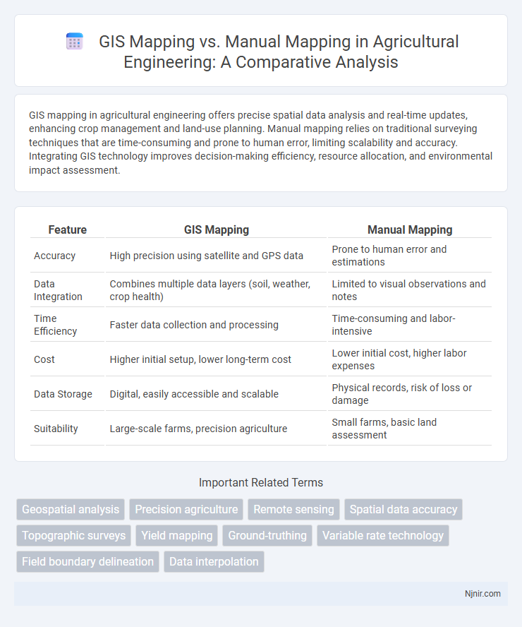
Table of Comparison
| Feature | GIS Mapping | Manual Mapping |
|---|---|---|
| Accuracy | High precision using satellite and GPS data | Prone to human error and estimations |
| Data Integration | Combines multiple data layers (soil, weather, crop health) | Limited to visual observations and notes |
| Time Efficiency | Faster data collection and processing | Time-consuming and labor-intensive |
| Cost | Higher initial setup, lower long-term cost | Lower initial cost, higher labor expenses |
| Data Storage | Digital, easily accessible and scalable | Physical records, risk of loss or damage |
| Suitability | Large-scale farms, precision agriculture | Small farms, basic land assessment |
Introduction to GIS and Manual Mapping in Agriculture
GIS mapping in agriculture leverages Geographic Information Systems technology to collect, analyze, and visualize spatial data, enabling precise crop monitoring and resource management. Manual mapping relies on traditional methods like hand-drawn maps and manual data recording, which can be time-consuming and prone to human error. GIS provides dynamic, scalable, and accurate spatial analysis, improving decision-making and efficiency in agricultural practices.
Key Differences Between GIS and Manual Mapping
GIS mapping utilizes digital tools and spatial data to create accurate, scalable maps with dynamic layering options, while manual mapping involves hand-drawing maps on physical media, often resulting in less precision and scalability. GIS supports data integration from various sources, automated updates, and advanced spatial analysis, whereas manual mapping relies on static, labor-intensive processes prone to human error. The efficiency, data management capabilities, and spatial accuracy of GIS make it preferable for complex, large-scale mapping projects compared to traditional manual methods.
Accuracy and Precision: GIS vs. Manual Methods
GIS mapping offers superior accuracy and precision by leveraging satellite imagery, GPS data, and advanced algorithms that minimize human error and provide consistent spatial measurements. Manual mapping relies heavily on human interpretation and physical measurements, often resulting in variable accuracy due to subjective judgment and potential measurement inconsistencies. The integration of GIS technology enhances the reliability of spatial data, ensuring more precise and reproducible mapping outcomes compared to traditional manual methods.
Data Collection Techniques in GIS and Manual Mapping
GIS mapping employs advanced data collection techniques such as satellite imagery, GPS devices, and remote sensing to gather accurate, real-time spatial data, enhancing precision and efficiency. Manual mapping relies on traditional methods like field surveys, paper-based sketches, and direct observation, which are time-consuming and prone to human error. The integration of automated sensors in GIS facilitates dynamic updates and large-scale data analysis, contrasting with the static and localized nature of manual mapping data.
Efficiency and Time Management Comparison
GIS mapping significantly enhances efficiency and time management by automating data collection, analysis, and visualization processes that manual mapping accomplishes through slow, labor-intensive methods. The integration of real-time data and advanced spatial analysis in GIS reduces errors and accelerates decision-making, whereas manual mapping relies on physical measurements and sketches, leading to longer project timelines. Overall, GIS mapping offers scalable, accurate solutions that optimize resource allocation and drastically cut project completion times compared to manual approaches.
Cost Implications: GIS Mapping vs. Manual Mapping
GIS mapping significantly reduces long-term costs by automating data collection, processing, and analysis, minimizing human labor and errors. Manual mapping demands higher ongoing expenses due to extensive fieldwork, paper materials, and slower data updates, resulting in inefficiencies. Investment in GIS technology offers scalable solutions that lower operational costs and improve accuracy compared to traditional manual methods.
Scalability and Flexibility in Agricultural Applications
GIS mapping offers superior scalability in agricultural applications by efficiently processing large datasets and enabling real-time analysis of spatial information such as soil health, crop yields, and weather patterns. Manual mapping, limited by human labor and time constraints, struggles to keep pace with evolving farm landscapes and lacks the flexibility to quickly update or integrate diverse data sources. The integration of GIS technology enhances farm management decisions through dynamic mapping capabilities, spatial analytics, and seamless data integration, driving precision agriculture and resource optimization.
Data Visualization and Decision Support
GIS mapping offers dynamic data visualization through interactive layers and real-time spatial analysis, enhancing pattern recognition and trend identification. Manual mapping relies on static, often less detailed visual representations that can limit comprehensive understanding of spatial relationships. Advanced GIS platforms improve decision support by integrating diverse datasets, enabling precise scenario modeling and data-driven strategies.
Case Studies: Real-world Applications in Agriculture
GIS mapping enhances agricultural productivity by enabling precise soil analysis, crop monitoring, and irrigation management, as demonstrated in case studies from California vineyards and Indian sugarcane fields. Manual mapping, while cost-effective, often lacks the spatial accuracy and scalability required for large-scale farm management, as observed in smallholder farms in sub-Saharan Africa. These real-world applications highlight GIS mapping's superior capacity for integrating multi-layered data, improving decision-making, and optimizing resource allocation in modern agriculture.
Future Trends in Agricultural Mapping Technologies
GIS mapping is revolutionizing agricultural mapping by providing precise spatial data integration, enabling real-time monitoring of crop health, soil conditions, and irrigation patterns. Future trends emphasize the integration of AI-driven analytics and drone-based GIS platforms to enhance accuracy and automate data collection, reducing human error prevalent in manual mapping. Advancements in sensor technology and cloud-based GIS will drive scalable and dynamic decision-making tools, surpassing the limitations of traditional manual methods.
Geospatial analysis
GIS mapping enhances geospatial analysis by providing accurate spatial data visualization and automated data integration, whereas manual mapping is time-consuming and prone to human error.
Precision agriculture
GIS mapping enhances precision agriculture by providing accurate, real-time spatial data for optimized crop management, whereas manual mapping relies on less precise, time-consuming field observations.
Remote sensing
GIS mapping integrates remote sensing data for precise, scalable spatial analysis, while manual mapping relies on limited, less accurate visual interpretation without automated data processing.
Spatial data accuracy
GIS mapping ensures higher spatial data accuracy by using precise geospatial algorithms and satellite data, whereas manual mapping relies on less precise, human-drawn estimates prone to errors.
Topographic surveys
GIS mapping provides faster, more accurate, and scalable topographic surveys compared to manual mapping, significantly reducing human error and enhancing data integration for geographic analysis.
Yield mapping
GIS mapping enhances yield mapping accuracy and efficiency by integrating spatial data with real-time field inputs, whereas manual mapping relies on labor-intensive, less precise data collection methods.
Ground-truthing
GIS mapping enhances ground-truthing accuracy by integrating satellite data with real-time field verification, whereas manual mapping relies solely on on-site observations, increasing the risk of human error and data inconsistencies.
Variable rate technology
GIS mapping enhances Variable Rate Technology by providing precise, data-driven field variability insights, whereas manual mapping relies on subjective observation and is less accurate for optimizing input applications.
Field boundary delineation
GIS mapping offers precise, scalable, and georeferenced field boundary delineation compared to manual mapping, which is time-consuming and prone to inaccuracies.
Data interpolation
GIS mapping uses advanced algorithms to perform accurate and efficient data interpolation, whereas manual mapping relies on subjective estimation, leading to less precise spatial data representation.
GIS mapping vs Manual mapping Infographic