UAV mapping offers higher resolution and real-time data collection, enabling precise monitoring of crop health and soil conditions. Satellite imagery provides broader coverage and historical data but often lacks the detailed spatial accuracy needed for site-specific management. Combining UAV and satellite data optimizes decision-making by leveraging both local precision and large-scale environmental insights.
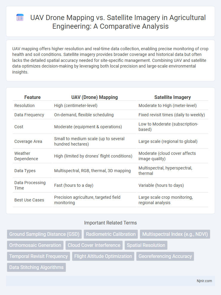
Table of Comparison
| Feature | UAV (Drone) Mapping | Satellite Imagery |
|---|---|---|
| Resolution | High (centimeter-level) | Moderate to High (meter-level) |
| Data Frequency | On-demand, flexible scheduling | Fixed revisit times (daily to weekly) |
| Cost | Moderate (equipment & operations) | Low to Moderate (subscription-based) |
| Coverage Area | Small to medium scale (up to several hundred hectares) | Large scale (regional to global) |
| Weather Dependence | High (limited by drones' flight conditions) | Moderate (cloud cover affects image quality) |
| Data Types | Multispectral, RGB, thermal, 3D mapping | Multispectral, hyperspectral, thermal |
| Data Processing Time | Fast (hours to a day) | Variable (hours to days) |
| Best Use Cases | Precision agriculture, targeted field monitoring | Large scale crop monitoring, regional analysis |
Introduction to Aerial Remote Sensing in Agriculture
UAV mapping offers high-resolution, real-time aerial remote sensing ideal for precision agriculture, enabling farmers to monitor crop health, soil conditions, and irrigation with greater accuracy than satellite imagery. While satellite imagery covers broader areas and provides historical data, UAVs can capture detailed multispectral images at lower altitudes, improving early detection of pests and diseases. Combining UAV mapping and satellite data enhances agricultural decision-making through comprehensive spatial analysis and site-specific management.
Overview of UAV (Drone) Mapping Technologies
UAV (drone) mapping technologies leverage advanced sensors such as LiDAR, multispectral, and high-resolution RGB cameras to capture precise geospatial data at low altitudes, enabling centimeter-level accuracy and rapid data acquisition. These systems utilize GNSS and RTK positioning for enhanced georeferencing, facilitating detailed 3D models and orthomosaics that surpass the spatial resolution limitations of many satellite images. Compared to satellite imagery, UAV mapping offers customizable flight paths, temporal flexibility, and superior detail, making it ideal for applications requiring up-to-date and high-resolution data.
Satellite Imagery: Capabilities and Limitations
Satellite imagery offers extensive geographic coverage with consistent revisit cycles, making it ideal for monitoring large-scale environmental changes and urban development. High-resolution satellites can capture detailed images down to 30 centimeters per pixel, yet spatial resolution and cloud cover remain significant limitations for precise, localized mapping tasks. Compared to UAV mapping, satellite data often lacks the flexibility for targeted data acquisition and timely updates but excels in providing historical archives and global context.
Spatial Resolution: Drones vs. Satellites
UAV mapping offers spatial resolution typically ranging from 1 to 5 centimeters per pixel, significantly surpassing satellite imagery, which often ranges between 0.3 to 10 meters per pixel depending on the satellite system. High-resolution drones enable detailed, accurate topographic and orthomosaic mapping in localized areas, making them ideal for precision agriculture, construction, and environmental monitoring. Satellites provide broader geographical coverage but lack the fine spatial resolution UAVs deliver for detailed site analysis and micro-scale data collection.
Temporal Resolution and Data Acquisition Frequency
UAV mapping offers significantly higher temporal resolution than satellite imagery, enabling data acquisition multiple times per day for dynamic monitoring of specific sites. Satellite imagery is limited by orbital revisit times, often capturing data every few days to weeks, which restricts its use for rapid change detection. Frequent UAV flights provide precise, up-to-date spatial information crucial for applications like agriculture, construction, and disaster response where timely data is essential.
Cost Comparison: UAV Mapping vs. Satellite Imagery
UAV mapping offers significantly lower costs for small to medium-sized projects compared to satellite imagery, primarily due to reduced fees for data acquisition and processing. Satellite imagery incurs higher expenses linked to licensing, high-resolution image procurement, and limited revisit times, which affect project budgets especially for frequent monitoring. UAVs provide customizable flight paths and on-demand data collection, enabling cost-effective, high-resolution mapping tailored to specific project requirements, outperforming satellite solutions in budget flexibility.
Data Processing and Accessibility
UAV mapping offers high-resolution, real-time data with more frequent updates and precise control over image capture angles, enabling faster and localized data processing compared to satellite imagery, which relies on broader, lower-resolution captures that require extensive post-processing. UAV data processing benefits from advanced photogrammetry software that can quickly generate detailed 3D models and orthomosaics, facilitating immediate analysis on-site or via cloud platforms. Accessibility to UAV mapping is enhanced by flexible deployment and lower operational costs, whereas satellite imagery depends on scheduled overpasses and subscription-based access, limiting temporal resolution and customization for specific sites.
Applications in Precision Agriculture
UAV mapping offers higher resolution and real-time data capture compared to satellite imagery, enabling precise monitoring of crop health, soil variability, and irrigation efficiency in precision agriculture. Drones can collect multispectral and hyperspectral data at low altitudes, providing detailed insight into plant stress, pest infestations, and nutrient deficiencies that satellites, limited by fixed revisit times and atmospheric interference, cannot match. This enhanced spatial and temporal resolution supports targeted interventions, optimizing input use and increasing crop yield sustainability.
Limitations and Challenges of UAVs and Satellites
UAV mapping faces limitations including restricted flight duration, payload capacity, and sensitivity to weather conditions, which can hinder data collection accuracy and consistency. Satellite imagery suffers from lower spatial resolution, temporal latency, and atmospheric interference, impacting its precision and timeliness for detailed mapping tasks. Both technologies encounter challenges with regulatory restrictions and data processing complexities that affect widespread deployment and real-time application.
Future Trends in Agricultural Imagery and Remote Sensing
UAV mapping offers higher resolution and real-time data collection compared to satellite imagery, making it ideal for precision agriculture and crop monitoring. Future trends indicate increased integration of AI and machine learning in UAV data analysis, enhancing predictive analytics and soil health assessment. Satellite imagery will complement UAV mapping by providing broader coverage and historical data, supporting large-scale agricultural decision-making and climate resilience strategies.
Ground Sampling Distance (GSD)
UAV mapping achieves significantly finer Ground Sampling Distance (GSD) often below 2 cm/pixel compared to typical satellite imagery GSD ranging from 30 cm to several meters per pixel, enabling more precise and detailed surface analysis.
Radiometric Calibration
UAV mapping provides higher radiometric calibration accuracy than satellite imagery by enabling precise sensor-specific corrections and real-time environmental adjustments.
Multispectral Index (e.g., NDVI)
UAV mapping captures high-resolution multispectral index data such as NDVI with greater spatial detail and temporal frequency compared to satellite imagery, enhancing precision in vegetation monitoring and agricultural management.
Orthomosaic Generation
UAV mapping generates higher-resolution orthomosaics with greater accuracy and flexibility in data capture compared to satellite imagery, enabling detailed terrain analysis and real-time updates.
Cloud Cover Interference
UAV mapping provides higher-resolution data with minimal cloud cover interference compared to satellite imagery, which often suffers from significant data loss and reduced accuracy due to persistent cloud cover.
Spatial Resolution
UAV mapping offers centimeter-level spatial resolution compared to satellite imagery's typical meter-level resolution, enabling more detailed and accurate land analysis.
Temporal Revisit Frequency
UAV mapping offers significantly higher temporal revisit frequency than satellite imagery, enabling more frequent data collection for dynamic site monitoring and rapid change detection.
Flight Altitude Optimization
Optimizing flight altitude in UAV mapping enhances spatial resolution and data accuracy far beyond the fixed high-altitude limitations of satellite imagery.
Georeferencing Accuracy
UAV mapping achieves higher georeferencing accuracy than satellite imagery by capturing high-resolution, low-altitude images with precise GPS data for detailed, localized spatial analysis.
Data Stitching Algorithms
UAV mapping utilizes advanced data stitching algorithms such as Structure-from-Motion (SfM) and Multi-View Stereo (MVS) to generate high-resolution, georeferenced orthomosaics that offer superior spatial detail and customization compared to conventional satellite imagery.
UAV (drone) mapping vs Satellite imagery Infographic