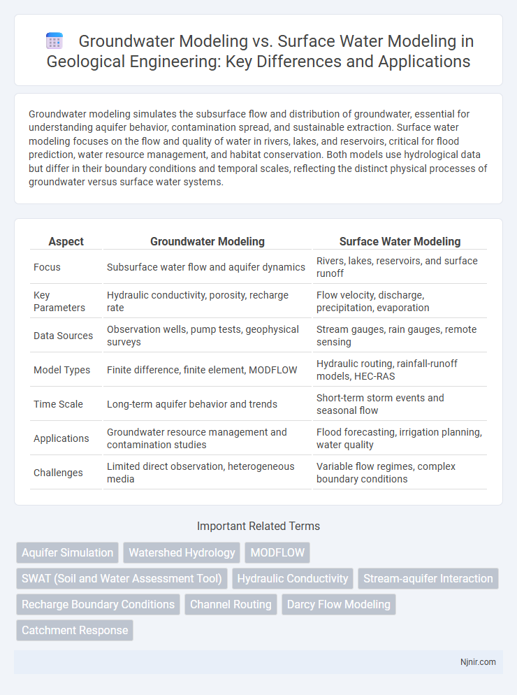
Groundwater modeling simulates the subsurface flow and distribution of groundwater, essential for understanding aquifer behavior, contamination spread, and sustainable extraction. Surface water modeling focuses on the flow and quality of water in rivers, lakes, and reservoirs, critical for flood prediction, water resource management, and habitat conservation. Both models use hydrological data but differ in their boundary conditions and temporal scales, reflecting the distinct physical processes of groundwater versus surface water systems.
Table of Comparison
| Aspect | Groundwater Modeling | Surface Water Modeling |
|---|---|---|
| Focus | Subsurface water flow and aquifer dynamics | Rivers, lakes, reservoirs, and surface runoff |
| Key Parameters | Hydraulic conductivity, porosity, recharge rate | Flow velocity, discharge, precipitation, evaporation |
| Data Sources | Observation wells, pump tests, geophysical surveys | Stream gauges, rain gauges, remote sensing |
| Model Types | Finite difference, finite element, MODFLOW | Hydraulic routing, rainfall-runoff models, HEC-RAS |
| Time Scale | Long-term aquifer behavior and trends | Short-term storm events and seasonal flow |
| Applications | Groundwater resource management and contamination studies | Flood forecasting, irrigation planning, water quality |
| Challenges | Limited direct observation, heterogeneous media | Variable flow regimes, complex boundary conditions |
Introduction to Water Modeling in Geological Engineering
Groundwater modeling simulates subsurface water flow and contaminant transport within aquifers, using numerical methods to analyze hydraulic conductivity, porosity, and recharge rates. Surface water modeling focuses on river, lake, and watershed hydrodynamics, accounting for precipitation, runoff, evaporation, and channel morphology. Both types of water modeling integrate hydrogeological data, geological formations, and environmental parameters to support groundwater management and surface water resource planning in geological engineering.
Fundamental Concepts: Groundwater vs Surface Water
Groundwater modeling focuses on simulating subsurface water flow through aquifers, considering parameters like hydraulic conductivity, porosity, and recharge rates to predict water table fluctuations and contaminant transport. Surface water modeling addresses the movement of water in rivers, lakes, and reservoirs, emphasizing streamflow dynamics, channel geometry, and rainfall-runoff relationships. Understanding fundamental differences such as the porous media flow in groundwater versus open channel flow in surface water is crucial for accurate hydrologic and hydraulic predictions.
Key Objectives of Groundwater Modeling
Groundwater modeling focuses on simulating subsurface water flow and contaminant transport to predict aquifer behavior, manage water resources, and assess contamination risks. Key objectives include estimating groundwater recharge rates, evaluating sustainable pumping limits, and predicting the impact of land-use changes on aquifer systems. Unlike surface water modeling, which analyzes rivers, lakes, and runoff, groundwater modeling emphasizes subsurface hydrodynamics and long-term aquifer sustainability.
Primary Goals of Surface Water Modeling
Surface water modeling primarily aims to simulate hydrological processes such as rainfall-runoff, river flow, and floodplain dynamics to manage water resources and predict flood risks accurately. It supports infrastructure design, flood forecasting, and water quality assessment by analyzing surface water behavior under varying climatic and land-use conditions. These models optimize water allocation, enhance disaster preparedness, and aid environmental impact studies, distinguishing them from groundwater models focused on subsurface flow and aquifer behavior.
Data Requirements and Collection Methods
Groundwater modeling requires detailed subsurface data including aquifer properties, hydraulic conductivity, and groundwater levels obtained through well drilling, piezometers, and geophysical surveys. Surface water modeling depends heavily on hydrological and meteorological data such as streamflow measurements, precipitation records, and watershed topography collected using gauging stations, remote sensing, and GIS tools. Precision in data collection methods directly influences the accuracy of model simulations for both groundwater flow and surface water dynamics.
Common Modeling Techniques and Tools
Groundwater modeling frequently employs numerical methods such as MODFLOW and FEFLOW to simulate subsurface flow and contaminant transport, using finite difference or finite element techniques, while surface water modeling often utilizes tools like HEC-RAS and SWAT to analyze river hydraulics and watershed hydrology through one-dimensional or distributed models. Both groundwater and surface water models rely on inputs like hydraulic conductivity, recharge rates, and boundary conditions, but groundwater models emphasize aquifer properties and porosity, whereas surface water models focus on rainfall-runoff processes and channel geometry. Integration of GIS data and remote sensing enhances spatial accuracy in both modeling approaches, supporting effective water resource management and flood risk assessment.
Scale and Resolution Considerations
Groundwater modeling typically operates at finer spatial resolutions to capture subsurface heterogeneity, such as aquifer properties and flow paths, often at scales ranging from meters to kilometers. Surface water modeling usually covers larger scales, like entire river basins or watersheds, emphasizing channel networks and runoff processes with coarser resolution grids or mesh sizes. Scale and resolution choices in both models are crucial for accurate simulation of hydrological processes and depend heavily on the study objectives, data availability, and computational resources.
Calibration, Validation, and Uncertainty in Models
Calibration in groundwater modeling involves adjusting hydraulic conductivity and recharge rates to match observed water levels, whereas surface water modeling calibrates parameters like Manning's roughness and channel geometry to fit streamflow data. Validation for groundwater models often uses independent well observations or tracer tests, while surface water models rely on observed hydrographs from gauging stations. Uncertainty in groundwater models arises from heterogeneous subsurface properties and limited data, whereas surface water model uncertainty is influenced by variable rainfall input and land use dynamics.
Applications in Engineering and Environmental Management
Groundwater modeling is essential for assessing aquifer recharge, contamination risk, and subsurface flow dynamics in environmental remediation and water resource management. Surface water modeling supports flood risk analysis, watershed management, and hydraulic infrastructure design by simulating river flow, runoff, and sediment transport. Both models integrate to optimize sustainable engineering solutions and ecosystem protection in complex hydrological systems.
Future Trends and Integration of Water Modeling Approaches
Advancements in groundwater modeling prioritize machine learning algorithms and high-resolution subsurface data to enhance predictive accuracy, while surface water modeling increasingly leverages real-time sensor networks and climate-resilient simulation frameworks. Future trends indicate a growing convergence of groundwater and surface water models through integrated hydrological platforms that enable comprehensive watershed-scale analysis. The integration facilitates improved water resource management by capturing complex interactions such as groundwater-surface water exchanges and supporting adaptive strategies amid climate variability.
Aquifer Simulation
Aquifer simulation in groundwater modeling uses numerical methods to predict subsurface water flow and contaminant transport, whereas surface water modeling focuses on river, lake, and watershed dynamics to manage surface hydrology.
Watershed Hydrology
Groundwater modeling simulates subsurface water flow and storage within aquifers, while surface water modeling focuses on runoff, streamflow, and watershed hydrology dynamics, essential for integrated water resource management.
MODFLOW
MODFLOW specializes in simulating groundwater flow through porous media using finite-difference methods, while surface water modeling typically addresses river, lake, and watershed processes with different hydrodynamic and hydraulic approaches.
SWAT (Soil and Water Assessment Tool)
SWAT is primarily designed for surface water modeling by simulating watershed hydrology, sediment transport, and nutrient cycling, while groundwater modeling requires specialized tools like MODFLOW for detailed subsurface flow analysis.
Hydraulic Conductivity
Groundwater modeling requires precise hydraulic conductivity values to simulate subsurface flow through porous media, while surface water modeling typically focuses on surface roughness and flow resistance rather than hydraulic conductivity.
Stream-aquifer Interaction
Stream-aquifer interaction is a critical focus in groundwater modeling to accurately simulate subsurface flow dynamics, whereas surface water modeling primarily addresses overland flow and channel hydraulics without detailed representation of groundwater exchange.
Recharge Boundary Conditions
Recharge boundary conditions in groundwater modeling simulate subsurface water infiltration rates, whereas surface water modeling incorporates recharge primarily through direct precipitation and runoff inputs on catchment surfaces.
Channel Routing
Channel routing in surface water modeling simulates flow within river channels to predict flood propagation, whereas groundwater modeling focuses on subsurface flow dynamics and aquifer interactions without detailed channel flow representation.
Darcy Flow Modeling
Darcy flow modeling plays a critical role in groundwater modeling by simulating subsurface fluid movement through porous media, whereas surface water modeling predominantly addresses open-channel hydraulics and overland flow dynamics.
Catchment Response
Groundwater modeling simulates subsurface flow and storage to predict delayed catchment response, while surface water modeling focuses on rapid runoff and channel flow affecting immediate catchment discharge.
Groundwater modeling vs Surface water modeling Infographic