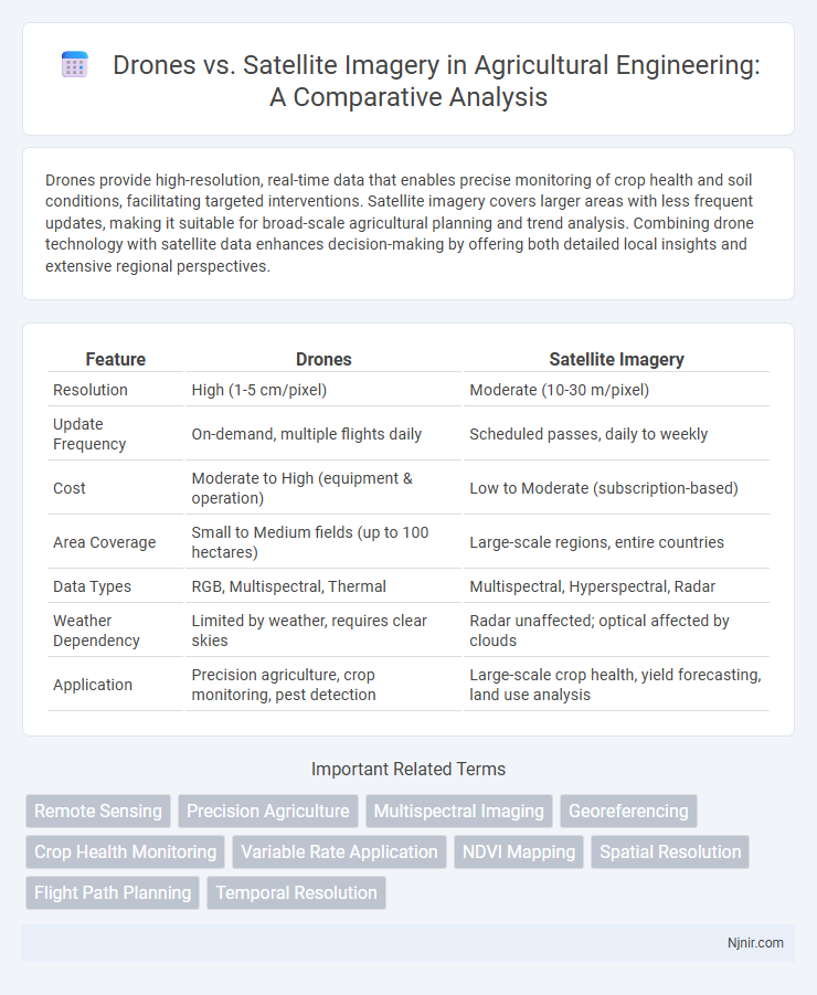
Drones provide high-resolution, real-time data that enables precise monitoring of crop health and soil conditions, facilitating targeted interventions. Satellite imagery covers larger areas with less frequent updates, making it suitable for broad-scale agricultural planning and trend analysis. Combining drone technology with satellite data enhances decision-making by offering both detailed local insights and extensive regional perspectives.
Table of Comparison
| Feature | Drones | Satellite Imagery |
|---|---|---|
| Resolution | High (1-5 cm/pixel) | Moderate (10-30 m/pixel) |
| Update Frequency | On-demand, multiple flights daily | Scheduled passes, daily to weekly |
| Cost | Moderate to High (equipment & operation) | Low to Moderate (subscription-based) |
| Area Coverage | Small to Medium fields (up to 100 hectares) | Large-scale regions, entire countries |
| Data Types | RGB, Multispectral, Thermal | Multispectral, Hyperspectral, Radar |
| Weather Dependency | Limited by weather, requires clear skies | Radar unaffected; optical affected by clouds |
| Application | Precision agriculture, crop monitoring, pest detection | Large-scale crop health, yield forecasting, land use analysis |
Introduction to Remote Sensing in Agriculture
Remote sensing in agriculture utilizes both drones and satellite imagery to monitor crop health, soil conditions, and irrigation efficiency. Drones offer high-resolution, real-time data capture with flexible deployment, enabling precise analysis of small or irregular fields. Satellite imagery provides broader spatial coverage and consistent temporal frequency, supporting large-scale agricultural planning and environmental monitoring.
Understanding Drone Imaging Technology
Drone imaging technology utilizes high-resolution cameras and sensors to capture detailed aerial images at low altitudes, offering real-time data with greater flexibility compared to satellite imagery. These drones employ GPS and advanced stabilization systems to ensure precise mapping and can cover smaller areas with higher spatial resolution. The ability to fly below cloud cover and revisit specific locations frequently makes drone imaging an effective tool for dynamic environmental monitoring, agriculture, and infrastructure inspection.
Satellite Imagery: Capabilities and Applications
Satellite imagery provides extensive geographic coverage with high-resolution data that enables detailed analysis of large-scale environmental changes, urban development, and disaster management. Advanced multispectral and hyperspectral sensors capture diverse spectral bands, facilitating applications in agriculture monitoring, climate research, and natural resource management. Continuous satellite data acquisition supports time-series analysis for tracking dynamic phenomena such as deforestation, glacier retreat, and oceanographic patterns.
Data Accuracy: Drones vs Satellite Imagery
Drones provide higher data accuracy than satellite imagery due to their ability to capture high-resolution images at low altitudes, resulting in precise spatial details and real-time updates for specific areas. Satellite imagery often has lower resolution and may be affected by atmospheric conditions, reducing accuracy and limiting frequency of data collection. The close-range data acquisition from drones significantly enhances map precision and object detection compared to the broader but less detailed satellite images.
Cost-Benefit Analysis for Farmers
Drones offer farmers high-resolution, real-time imagery at a fraction of the cost of satellite data, enabling precise monitoring of crop health and irrigation needs. While satellite imagery covers larger areas and provides frequent updates, the initial investment and subscription fees can be significantly higher than the cost of deploying drones. The choice depends on farm size, budget constraints, and specific agricultural needs, with drones often delivering greater cost-effectiveness for small to medium-scale operations.
Resolution Comparison: Drones and Satellites
Drone imagery typically offers ultra-high resolution, capturing details as fine as 1-5 centimeters per pixel, which surpasses most commercial satellites that provide resolutions around 30 centimeters to 1 meter per pixel. Satellites cover vast areas with lower spatial resolution, ideal for regional and global analysis, whereas drones excel in localized, detailed inspections due to their proximity to targets. This resolution advantage enables drones to support precision agriculture, infrastructure monitoring, and detailed mapping with greater accuracy than satellite imagery.
Real-Time Monitoring and Responsiveness
Drones deliver high-resolution images with real-time data transmission, enabling immediate analysis and rapid response in dynamic environments. Satellite imagery, while covering larger areas, often suffers from latency due to orbital passes and data processing times, limiting its real-time monitoring capabilities. The ability of drones to operate at low altitudes allows for precise, on-demand surveillance, making them ideal for urgent disaster assessment and infrastructure inspections.
Scalability for Large and Small Farms
Drones offer high-resolution, customizable imagery ideal for small to medium farms, enabling precise crop monitoring and targeted interventions. Satellite imagery provides scalable coverage for large agricultural regions, delivering consistent data across vast areas but with lower spatial resolution. Combining drone and satellite data optimizes scalability, balancing detailed insights with broad area surveillance to enhance farm management efficiency.
Limitations and Challenges of Each Technology
Drones face limitations such as restricted flight duration, limited coverage area, and dependence on weather conditions, which can hamper consistent data collection. Satellite imagery struggles with lower spatial resolution compared to drones, cloud cover interference, and longer revisit times, affecting real-time monitoring capabilities. Both technologies require significant investment in data processing and interpretation to ensure accuracy and actionable insights.
Future Trends in Agricultural Remote Sensing
The future of agricultural remote sensing is increasingly dominated by the integration of drones and satellite imagery, leveraging high-resolution data from drones with the broad coverage of satellites. Advances in AI and machine learning enhance the precision of crop monitoring, disease detection, and soil analysis by fusing multispectral and hyperspectral data from both platforms. Innovations in real-time data processing and cloud computing will drive more efficient decision-making, crop yield prediction, and resource optimization in smart farming systems.
Remote Sensing
Drones offer high-resolution, flexible remote sensing capabilities ideal for localized data collection, while satellite imagery provides broad-area coverage and long-term monitoring essential for large-scale environmental analysis.
Precision Agriculture
Drones provide higher-resolution imagery than satellites, enabling more precise crop monitoring and targeted interventions in precision agriculture.
Multispectral Imaging
Drones equipped with multispectral imaging provide higher-resolution, real-time data compared to satellite imagery, enabling precise crop health monitoring and environmental analysis.
Georeferencing
Drones provide high-resolution, real-time georeferenced imagery ideal for localized mapping, whereas satellite imagery offers broader coverage with varying georeferencing accuracy depending on sensor type and orbits.
Crop Health Monitoring
Drones provide high-resolution, real-time crop health monitoring with precise multispectral imaging, outperforming satellite imagery's lower resolution and limited revisit times in detecting early stress and disease.
Variable Rate Application
Drones provide high-resolution, real-time data enabling precise Variable Rate Application (VRA) in agriculture, outperforming satellite imagery's lower resolution and less frequent revisit times.
NDVI Mapping
Drones provide high-resolution, real-time NDVI mapping with greater flexibility and lower cost compared to satellite imagery, which offers broader coverage but lower spatial resolution and less frequent updates.
Spatial Resolution
Drones capture high spatial resolution imagery down to centimeters per pixel, far surpassing the typically meter-level spatial resolution of satellite imagery for detailed ground-level analysis.
Flight Path Planning
Flight path planning in drones enables precise, customizable data collection for high-resolution imagery, whereas satellites follow fixed orbits limiting real-time route adjustments for specific area coverage.
Temporal Resolution
Drones offer superior temporal resolution by enabling frequent, on-demand data capture compared to satellites, which have fixed revisit intervals ranging from hours to days.
Drones vs Satellite imagery Infographic