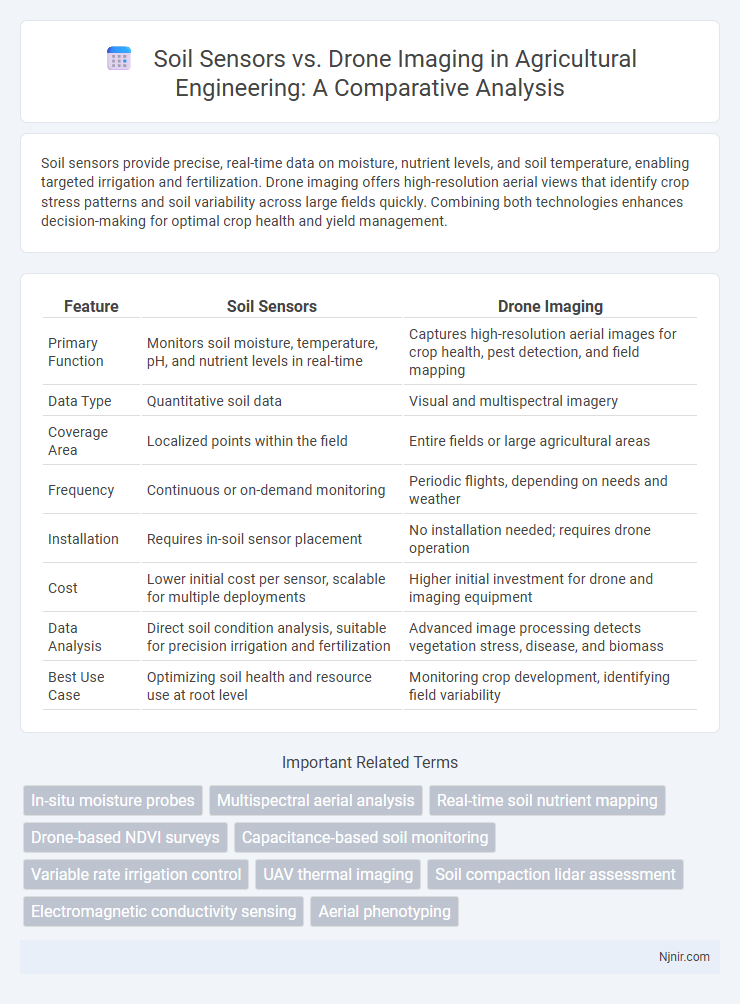
Soil sensors provide precise, real-time data on moisture, nutrient levels, and soil temperature, enabling targeted irrigation and fertilization. Drone imaging offers high-resolution aerial views that identify crop stress patterns and soil variability across large fields quickly. Combining both technologies enhances decision-making for optimal crop health and yield management.
Table of Comparison
| Feature | Soil Sensors | Drone Imaging |
|---|---|---|
| Primary Function | Monitors soil moisture, temperature, pH, and nutrient levels in real-time | Captures high-resolution aerial images for crop health, pest detection, and field mapping |
| Data Type | Quantitative soil data | Visual and multispectral imagery |
| Coverage Area | Localized points within the field | Entire fields or large agricultural areas |
| Frequency | Continuous or on-demand monitoring | Periodic flights, depending on needs and weather |
| Installation | Requires in-soil sensor placement | No installation needed; requires drone operation |
| Cost | Lower initial cost per sensor, scalable for multiple deployments | Higher initial investment for drone and imaging equipment |
| Data Analysis | Direct soil condition analysis, suitable for precision irrigation and fertilization | Advanced image processing detects vegetation stress, disease, and biomass |
| Best Use Case | Optimizing soil health and resource use at root level | Monitoring crop development, identifying field variability |
Introduction to Soil Sensors and Drone Imaging in Agriculture
Soil sensors provide real-time data on moisture, nutrient levels, and temperature, enabling precise monitoring of soil health for optimal crop growth. Drone imaging offers high-resolution aerial views, capturing detailed information on crop conditions, pest infestations, and irrigation needs across large agricultural fields. Combining soil sensors with drone imaging enhances precision agriculture by delivering comprehensive insights for improved yield management and resource efficiency.
Key Technologies Behind Soil Sensors
Soil sensors rely on advanced technologies such as capacitive moisture sensing, electrical conductivity measurement, and temperature probes to monitor real-time soil conditions with high precision. These sensors utilize wireless communication protocols like LoRaWAN and NB-IoT to transmit data for immediate analysis, enabling efficient irrigation and nutrient management. Unlike drone imaging that uses multispectral and thermal cameras for surface analysis, soil sensors provide granular, in-situ insights critical for optimizing plant health and soil quality.
Overview of Drone Imaging for Soil Analysis
Drone imaging for soil analysis utilizes high-resolution multispectral and hyperspectral cameras to capture detailed aerial data, enabling precise monitoring of soil properties such as moisture levels, nutrient content, and texture variability across large agricultural fields. This technology offers rapid data collection and spatially comprehensive insights, facilitating targeted soil management and optimized crop production. Compared to traditional soil sensors, drone imaging provides a non-invasive, scalable solution that enhances decision-making through advanced image processing and machine learning algorithms.
Comparative Accuracy: Soil Sensors vs Drone Imaging
Soil sensors provide precise, real-time data on moisture, nutrient levels, and temperature directly from the root zone, ensuring highly localized and accurate measurements. Drone imaging offers broader spatial coverage through multispectral and thermal cameras but may suffer from resolution limitations and environmental interferences affecting data accuracy. Combining soil sensors with drone imaging enhances overall monitoring precision by integrating ground-truth data with aerial spatial analysis.
Data Collection Methods and Workflows
Soil sensors provide continuous, real-time data on moisture, temperature, and nutrient levels by being embedded directly in the field, enabling precise monitoring of subsurface conditions. Drone imaging captures multispectral and thermal images from above, offering rapid, large-scale assessment of crop health, soil variations, and irrigation patterns through aerial surveys. Integrating both methods enhances data workflows by combining high-resolution spatial imagery with localized, temporal soil metrics for comprehensive agricultural decision-making.
Cost Analysis: Initial Investment and Maintenance
Soil sensors typically require a lower initial investment, with costs ranging from $100 to $500 per unit, while drone imaging systems demand a higher upfront expense, often between $1,000 and $5,000 for drones equipped with multispectral cameras. Maintenance for soil sensors generally involves periodic calibration and battery replacement, resulting in minimal ongoing costs, whereas drone imaging incurs expenses for software updates, repairs, and pilot training, increasing long-term operational expenditure. Cost analysis reveals soil sensors as a more budget-friendly solution for continuous, localized monitoring, while drone imaging offers broader spatial data but at a higher financial commitment.
Real-Time Monitoring: Capabilities and Limitations
Soil sensors provide precise real-time data on moisture, temperature, and nutrient levels directly within the root zone, enabling targeted irrigation and fertilization with minimal delay. Drone imaging captures broad spatial variability through multispectral and thermal data but faces limitations in temporal resolution due to flight schedules and weather conditions. Together, soil sensors excel in continuous monitoring accuracy, while drones offer valuable spatial insights, although neither fully replaces the other's real-time responsiveness.
Scalability for Different Farm Sizes
Soil sensors offer precise, real-time data suited for scalable deployment across small to medium farms, enabling detailed soil health monitoring with minimal labor. Drone imaging excels in scalability for large farms, providing rapid, high-resolution aerial data that captures crop health and field variability over extensive areas. Combining soil sensors with drone imaging enhances scalability by leveraging ground-level accuracy and broad aerial perspectives for farms of all sizes.
Integrating Soil Sensors and Drone Imaging for Precision Agriculture
Integrating soil sensors and drone imaging enhances precision agriculture by providing real-time, high-resolution data on soil moisture, nutrient levels, and crop health. Soil sensors deliver localized, continuous monitoring of underground conditions, while drones capture aerial imagery that identifies spatial variability and stress patterns across large fields. Combining these technologies enables farmers to optimize irrigation, fertilization, and pest management decisions, improving yield and resource efficiency.
Future Trends and Innovations in Soil Monitoring Technologies
Soil sensors and drone imaging technologies are rapidly evolving with advancements in IoT integration, AI-driven data analytics, and real-time monitoring capabilities, enhancing precision in agricultural practices. Emerging innovations include hyperspectral imaging drones combined with machine learning algorithms for detailed soil nutrient mapping and autonomous soil sensor networks that provide continuous, localized soil health data. Future trends emphasize increased automation, enhanced sensor accuracy, and the fusion of multi-source data to optimize crop management and sustainable land use.
In-situ moisture probes
In-situ moisture probes provide precise, real-time soil water content data that enhances irrigation management, offering higher accuracy than drone imaging's remote soil moisture estimates.
Multispectral aerial analysis
Multispectral aerial analysis via drones provides high-resolution, real-time data on crop health and soil conditions, complementing soil sensors by enabling precise, large-scale monitoring of variables such as moisture, nutrient levels, and vegetation indices.
Real-time soil nutrient mapping
Soil sensors provide precise real-time soil nutrient mapping by continuously monitoring nutrient levels at the root zone, while drone imaging offers broader spatial analysis but with less immediate nutrient-specific data.
Drone-based NDVI surveys
Drone-based NDVI surveys provide high-resolution, real-time vegetation health data that surpasses soil sensors in spatial coverage and precision for efficient crop monitoring.
Capacitance-based soil monitoring
Capacitance-based soil sensors provide precise, real-time soil moisture data for targeted irrigation, while drone imaging offers broad spatial analysis but with less immediate soil moisture accuracy.
Variable rate irrigation control
Soil sensors provide real-time moisture data for precise Variable Rate Irrigation (VRI) control, whereas drone imaging offers spatial crop health insights that complement moisture data to optimize irrigation efficiency.
UAV thermal imaging
UAV thermal imaging provides precise, real-time soil temperature data that enhances crop monitoring and irrigation management compared to traditional soil sensors.
Soil compaction lidar assessment
Soil compaction lidar assessment using drone imaging provides high-resolution spatial data, surpassing traditional soil sensors by enabling precise, non-invasive mapping of soil density variations across extensive agricultural fields.
Electromagnetic conductivity sensing
Soil sensors using electromagnetic conductivity sensing provide precise, real-time soil property data, offering higher spatial resolution and direct measurement benefits compared to drone imaging techniques.
Aerial phenotyping
Aerial phenotyping using drone imaging provides high-resolution, large-scale crop monitoring compared to soil sensors, which offer localized, real-time soil condition data.
Soil sensors vs drone imaging Infographic