Drones offer high-resolution, real-time data collection for precision agriculture, enabling farmers to monitor crop health, soil conditions, and irrigation needs with greater accuracy than satellite imaging. While satellite imaging covers larger areas and provides broad-scale insights, it is limited by lower resolution and less frequent data updates compared to drones. Integrating drone technology with traditional satellite data enhances decision-making, promotes efficient resource management, and maximizes crop yields.
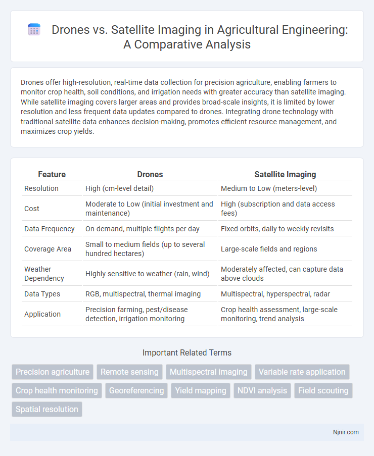
Table of Comparison
| Feature | Drones | Satellite Imaging |
|---|---|---|
| Resolution | High (cm-level detail) | Medium to Low (meters-level) |
| Cost | Moderate to Low (initial investment and maintenance) | High (subscription and data access fees) |
| Data Frequency | On-demand, multiple flights per day | Fixed orbits, daily to weekly revisits |
| Coverage Area | Small to medium fields (up to several hundred hectares) | Large-scale fields and regions |
| Weather Dependency | Highly sensitive to weather (rain, wind) | Moderately affected, can capture data above clouds |
| Data Types | RGB, multispectral, thermal imaging | Multispectral, hyperspectral, radar |
| Application | Precision farming, pest/disease detection, irrigation monitoring | Crop health assessment, large-scale monitoring, trend analysis |
Introduction to Drones and Satellite Imaging in Agriculture
Drones equipped with high-resolution cameras and multispectral sensors provide precise, real-time data for crop monitoring, enabling targeted interventions and improved yield predictions. Satellite imaging offers comprehensive, large-scale agricultural assessments through frequent, wide-area coverage and advanced spectral analysis across diverse geographic regions. Combining drone agility and satellite breadth enhances precision agriculture by optimizing resource management and detecting crop health variations early.
Key Applications in Precision Farming
Drones provide high-resolution, real-time imaging that enables precise monitoring of crop health, pest infestations, and irrigation needs, enhancing site-specific management in precision farming. Satellite imaging offers broad-area coverage and temporal data useful for tracking large-scale agricultural patterns and seasonal changes but with lower spatial resolution than drones. Combining drone and satellite data optimizes crop yield predictions and resource management by integrating detailed local insights with extensive regional analysis.
Resolution and Data Accuracy Comparison
Drones provide high-resolution imaging with spatial details often reaching sub-centimeter levels, making them ideal for localized, detailed surveys. Satellite imaging typically offers broader coverage but at a lower resolution, generally ranging from 30 centimeters to several meters per pixel, which can limit fine-scale analysis. Data accuracy in drones surpasses satellites in terms of real-time positional precision and the ability to capture targeted, flexible datasets, while satellites excel in consistent, large-area monitoring with georeferenced data accuracy dependent on sensor calibration and orbital parameters.
Cost Analysis and Accessibility
Drones offer significantly lower initial investment and operational costs compared to satellite imaging, making them more accessible for small to medium-scale projects. Their ability to capture high-resolution images on-demand without the need for expensive satellite data subscriptions enhances affordability. Satellite imaging provides extensive geographic coverage but entails higher costs and less flexibility, limiting accessibility for frequent or localized data collection.
Frequency of Data Collection
Drones offer the advantage of high-frequency data collection, capable of capturing images daily or even multiple times per day, which is ideal for monitoring rapid changes in agricultural fields, construction sites, or disaster areas. Satellite imaging, while providing broader coverage, typically collects data on a weekly to monthly basis, constrained by satellite revisit times and orbital paths. The increased temporal resolution from drones enables more timely decision-making and responsive management compared to the less frequent satellite passes.
Scalability for Large and Small Farms
Drones offer high-resolution, targeted imaging ideal for small to medium-sized farms, enabling precise monitoring and resource management. Satellite imaging provides extensive coverage suitable for large-scale agricultural operations, capturing broad patterns and seasonal changes over vast areas. Integrating both technologies enhances scalability, with drones delivering detailed insights and satellites ensuring comprehensive spatial analysis.
Weather and Environmental Limitations
Drones provide high-resolution, localized data but face limitations such as restricted flight duration, sensitivity to severe weather conditions like strong winds or heavy rain, and regulatory restrictions in urban areas. Satellite imaging offers broad geographic coverage and consistent data collection unaffected by local weather, though image resolution can be lower and cloud cover may obstruct optical sensors. Weather conditions impact drones more directly, while satellites rely on sensor type--radar satellites penetrate clouds, whereas optical satellites are obstructed by them.
Integration with Smart Farm Technologies
Drones provide high-resolution, real-time imaging that integrates seamlessly with IoT sensors and AI-driven farm management systems, enabling precise monitoring of crop health, soil conditions, and irrigation needs. Satellite imaging covers large areas with less frequent updates, complementing drones by offering broader environmental data and long-term trend analysis, essential for strategic planning in smart agriculture. Combining drone data with satellite imagery enhances decision-making accuracy, optimizing resource use and increasing crop yields in precision farming applications.
Case Studies: Drones and Satellites in Action
Case studies highlight drones' ability to capture high-resolution, localized images ideal for agriculture monitoring, disaster assessment, and infrastructure inspections, offering real-time data with flexible deployment. Satellite imaging excels in large-scale, continuous Earth observation, providing comprehensive coverage for climate monitoring, urban planning, and environmental tracking across vast regions. Combining drone data with satellite imagery enhances accuracy and detail, enabling precision analysis in sectors like forestry management and emergency response.
Future Trends in Agricultural Remote Sensing
Emerging trends in agricultural remote sensing highlight the integration of drone technology with satellite imaging to enhance crop monitoring and precision farming. Drones provide high-resolution, real-time data at a lower altitude, enabling detailed analysis of plant health, soil conditions, and pest infestation, while satellite imaging offers broader spatial coverage and temporal consistency. Advances in artificial intelligence and data fusion techniques are expected to optimize the complementary use of drones and satellites, driving improved decision-making and sustainable agricultural practices.
Precision agriculture
Drones provide higher-resolution imaging and real-time data for precision agriculture compared to satellites, enabling more accurate crop monitoring and timely interventions.
Remote sensing
Drones provide high-resolution, real-time remote sensing data with greater flexibility and lower costs compared to satellite imaging, making them ideal for localized environmental monitoring and precision agriculture.
Multispectral imaging
Drones equipped with multispectral imaging sensors provide higher spatial resolution and flexible data acquisition compared to satellites, enabling precise agricultural monitoring and environmental analysis.
Variable rate application
Drones enable precise variable rate application in agriculture by capturing high-resolution, real-time data that satellites cannot match due to lower resolution and infrequent imaging.
Crop health monitoring
Drones provide high-resolution, real-time crop health monitoring with precise multispectral imaging, outperforming satellites in detecting early stress and enabling targeted interventions.
Georeferencing
Drones provide higher-resolution georeferencing accuracy than satellite imaging by capturing real-time, low-altitude data with precise GPS integration.
Yield mapping
Drones provide high-resolution, real-time yield mapping with precise field-level data, surpassing satellite imaging's broader but lower-resolution crop monitoring capabilities.
NDVI analysis
Drones provide higher-resolution NDVI analysis compared to satellite imaging by capturing more frequent, localized data for precise vegetation health monitoring.
Field scouting
Drones provide high-resolution, real-time imagery for precise field scouting, enabling targeted crop monitoring and rapid identification of issues compared to the broader, less frequent coverage of satellite imaging.
Spatial resolution
Drones provide higher spatial resolution imaging with centimeter-level detail compared to satellites, which typically offer meter-level resolution suitable for broader area monitoring.
drones vs satellite imaging Infographic