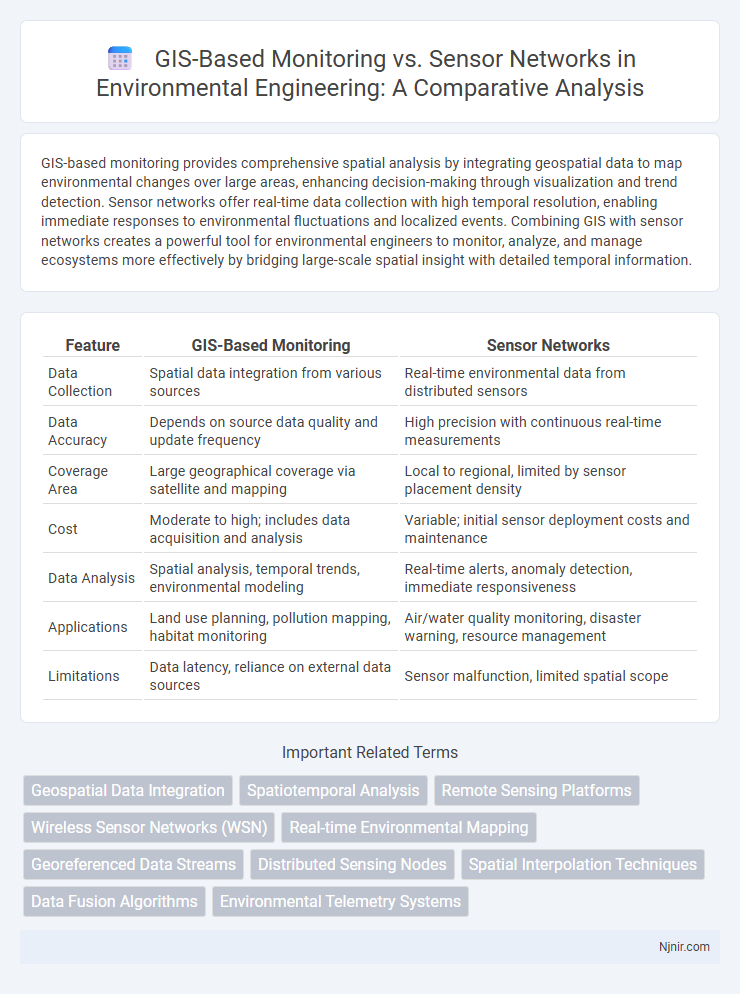
GIS-based monitoring provides comprehensive spatial analysis by integrating geospatial data to map environmental changes over large areas, enhancing decision-making through visualization and trend detection. Sensor networks offer real-time data collection with high temporal resolution, enabling immediate responses to environmental fluctuations and localized events. Combining GIS with sensor networks creates a powerful tool for environmental engineers to monitor, analyze, and manage ecosystems more effectively by bridging large-scale spatial insight with detailed temporal information.
Table of Comparison
| Feature | GIS-Based Monitoring | Sensor Networks |
|---|---|---|
| Data Collection | Spatial data integration from various sources | Real-time environmental data from distributed sensors |
| Data Accuracy | Depends on source data quality and update frequency | High precision with continuous real-time measurements |
| Coverage Area | Large geographical coverage via satellite and mapping | Local to regional, limited by sensor placement density |
| Cost | Moderate to high; includes data acquisition and analysis | Variable; initial sensor deployment costs and maintenance |
| Data Analysis | Spatial analysis, temporal trends, environmental modeling | Real-time alerts, anomaly detection, immediate responsiveness |
| Applications | Land use planning, pollution mapping, habitat monitoring | Air/water quality monitoring, disaster warning, resource management |
| Limitations | Data latency, reliance on external data sources | Sensor malfunction, limited spatial scope |
Introduction to GIS-Based Monitoring in Environmental Engineering
GIS-based monitoring in environmental engineering integrates spatial data analysis with environmental management, enabling precise mapping of natural resources and pollutant dispersal patterns. Unlike sensor networks that collect real-time localized data, GIS synthesizes multiple datasets, including satellite imagery, topographic maps, and demographic information, to assess large-scale environmental changes and risks. This spatially explicit approach supports effective decision-making for sustainable resource management and environmental impact assessments.
Overview of Sensor Networks for Environmental Data Collection
Sensor networks for environmental data collection consist of distributed sensors that capture real-time information such as temperature, humidity, air quality, and soil moisture across diverse ecosystems. These networks enable continuous monitoring with high spatial and temporal resolution, facilitating rapid detection of environmental changes and improved resource management. Integrating sensor data with Geographic Information Systems (GIS) enhances visualization, analysis, and decision-making for environmental monitoring and conservation efforts.
Key Differences: GIS-Based Monitoring vs. Sensor Networks
GIS-based monitoring integrates spatial data analysis and visualization to provide comprehensive mapping and geographic context, enabling detailed tracking of environmental changes over large areas. Sensor networks consist of distributed, real-time data collection devices that continuously measure specific physical parameters like temperature, humidity, or pollution levels within localized environments. While GIS emphasizes spatial relationships and historical data mapping, sensor networks excel in providing immediate, fine-grained, and dynamic measurements for real-time monitoring and rapid response applications.
Integration of GIS with Sensor Networks
Integration of GIS with sensor networks enables real-time spatial data visualization and analysis, enhancing decision-making for environmental monitoring and urban planning. Sensor networks provide continuous, location-specific data, which GIS processes to create dynamic, layered maps illustrating phenomena like air quality, traffic flow, or temperature variations. This synergy improves accuracy in tracking changes over time and supports predictive modeling for resource management and disaster response.
Spatial Data Accuracy and Resolution Considerations
GIS-based monitoring offers high spatial data accuracy through detailed satellite imagery and georeferenced maps, providing comprehensive resolution for large-scale environmental analysis. Sensor networks deliver fine-grained, real-time spatial resolution by deploying numerous localized devices capable of capturing micro-level variations. The integration of GIS spatial datasets with sensor network data enhances overall spatial accuracy and resolution, enabling precise environmental monitoring and decision-making.
Real-Time Monitoring Capabilities: GIS vs Sensor Networks
Sensor networks provide precise real-time monitoring by continuously collecting and transmitting data from distributed nodes, enabling instant detection of environmental changes. GIS-based monitoring integrates spatial data from multiple sources, offering comprehensive visual analysis but often with delays due to data processing and aggregation. The immediacy of sensor networks makes them superior for time-sensitive applications, while GIS excels in spatial context and long-term trend visualization.
Cost and Scalability in Environmental Monitoring Solutions
GIS-based monitoring systems offer scalable environmental data integration over large geographic areas with relatively low incremental costs, leveraging existing satellite and aerial imagery. Sensor networks require significant upfront investment for hardware deployment and maintenance but provide high-resolution, real-time data essential for localized monitoring. Cost-effectiveness depends on the monitoring scale and precision needs, with GIS favoring broad, large-scale applications and sensor networks excelling in detailed, site-specific environments.
Application Case Studies: GIS and Sensor Networks
GIS-based monitoring enhances spatial analysis in environmental management by integrating satellite imagery and geospatial data for comprehensive mapping. Sensor networks provide real-time, high-resolution data streams for applications such as urban air quality monitoring and precision agriculture. Case studies demonstrate combined GIS and sensor network use in disaster response, enabling dynamic hazard mapping and timely decision-making.
Challenges and Limitations in Current Technologies
GIS-based monitoring faces limitations such as data latency, spatial resolution constraints, and high costs associated with data acquisition and processing. Sensor networks encounter challenges including limited battery life, signal interference, and difficulties in maintaining sensor calibration over time. Both technologies struggle with data integration complexities and ensuring real-time, accurate environmental monitoring in dynamic and large-scale applications.
Future Trends in Environmental Monitoring Systems
Future trends in environmental monitoring systems emphasize the integration of GIS-based monitoring with advanced sensor networks to enhance spatial and temporal data accuracy. Emerging technologies leverage real-time data fusion and machine learning algorithms to optimize environmental analysis and predictive modeling. The convergence of IoT-enabled sensors and cloud-based GIS platforms enables scalable, intelligent monitoring solutions for dynamic ecosystem management.
Geospatial Data Integration
GIS-based monitoring enhances geospatial data integration by synthesizing diverse spatial datasets into unified maps, whereas sensor networks provide real-time, high-resolution environmental data streams essential for dynamic geospatial analysis.
Spatiotemporal Analysis
GIS-based monitoring enables comprehensive spatiotemporal analysis by integrating and visualizing diverse spatial and temporal data, while sensor networks provide real-time, high-resolution localized measurements essential for dynamic environmental monitoring.
Remote Sensing Platforms
Remote sensing platforms in GIS-based monitoring provide extensive spatial coverage and high-resolution data critical for environmental analysis, outperforming localized sensor networks in scalability and broad area surveillance.
Wireless Sensor Networks (WSN)
Wireless Sensor Networks (WSN) offer real-time, spatially distributed environmental monitoring with higher resolution and faster data transmission compared to traditional GIS-based monitoring systems.
Real-time Environmental Mapping
GIS-based monitoring integrates spatial data for comprehensive environmental analysis, while sensor networks provide real-time, high-frequency data crucial for dynamic environmental mapping and immediate decision-making.
Georeferenced Data Streams
Georeferenced data streams from sensor networks enable real-time spatial analysis and dynamic updating within GIS-based monitoring systems for enhanced environmental and infrastructure management.
Distributed Sensing Nodes
Distributed sensing nodes in sensor networks provide real-time, localized data collection that complements GIS-based monitoring by enhancing spatial resolution and enabling dynamic environmental analysis.
Spatial Interpolation Techniques
Spatial interpolation techniques in GIS-based monitoring enhance data accuracy by estimating unknown values from known sensor network points, optimizing spatial analysis and environmental monitoring.
Data Fusion Algorithms
Data fusion algorithms in GIS-based monitoring integrate spatial data with real-time sensor network inputs to enhance accuracy and decision-making in environmental and urban management.
Environmental Telemetry Systems
GIS-based monitoring offers comprehensive spatial analysis and visualization of environmental data, while sensor networks provide real-time, localized data collection essential for effective Environmental Telemetry Systems in tracking environmental changes.
GIS-based monitoring vs sensor networks Infographic