Geo-hazard mapping identifies and spatially visualizes natural hazards such as landslides, earthquakes, and floods to highlight vulnerable areas. Risk assessment evaluates the potential impacts and likelihood of these hazards on infrastructure, populations, and the environment, integrating exposure, vulnerability, and hazard data. Combining both processes enhances decision-making in geological engineering by providing comprehensive insights into hazard probabilities and consequences.
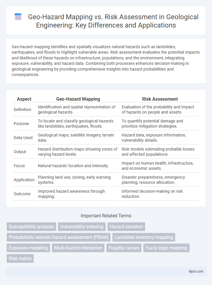
Table of Comparison
| Aspect | Geo-Hazard Mapping | Risk Assessment |
|---|---|---|
| Definition | Identification and spatial representation of geological hazards. | Evaluation of the probability and impact of hazards on people and assets. |
| Purpose | To locate and classify geological hazards like landslides, earthquakes, floods. | To quantify potential damage and prioritize mitigation strategies. |
| Data Used | Geological maps, satellite imagery, terrain data. | Hazard data, exposure information, vulnerability details. |
| Output | Hazard distribution maps showing zones of varying hazard levels. | Risk models estimating probable losses and affected populations. |
| Focus | Natural hazards' location and intensity. | Impact on human health, infrastructure, and economic assets. |
| Application | Planning land use, zoning, early warning systems. | Disaster preparedness, emergency planning, resource allocation. |
| Outcome | Improved hazard awareness through mapping. | Informed decision-making on risk reduction. |
Introduction to Geo-Hazard Mapping and Risk Assessment
Geo-hazard mapping involves identifying and documenting the spatial distribution of natural hazards such as landslides, earthquakes, and floods, providing crucial data for vulnerability analysis. Risk assessment builds on this by evaluating the potential impact of these hazards on populations, infrastructure, and the environment, quantifying the likelihood and severity of adverse outcomes. Integrating geospatial datasets with hazard models enhances decision-making for disaster preparedness and mitigation strategies.
Defining Geo-Hazards in Geological Engineering
Geo-hazard mapping involves identifying and spatially representing natural geological phenomena such as landslides, earthquakes, and floods that pose potential threats, while risk assessment evaluates the likelihood and potential impact of these hazards on human activities and infrastructure. Defining geo-hazards in geological engineering requires detailed analysis of terrain features, soil properties, seismic activity, and hydrological conditions to pinpoint vulnerable areas. Integrating geo-hazard mapping with risk assessment supports informed decision-making in land use planning and disaster mitigation strategies.
Objectives of Geo-Hazard Mapping
Geo-hazard mapping aims to identify and spatially delineate natural hazards such as landslides, floods, earthquakes, and volcanic activity based on geological and environmental data. It provides detailed information about hazard locations, intensities, and probabilities to support land-use planning, disaster preparedness, and infrastructure development. This proactive approach enables early warning systems, risk reduction strategies, and resource allocation to mitigate potential impacts on communities and ecosystems.
Fundamentals of Risk Assessment in Geology
Geo-hazard mapping identifies and spatially delineates areas susceptible to natural hazards such as landslides, earthquakes, or floods through geological and geotechnical data analysis. Risk assessment in geology quantifies potential losses by integrating hazard probability, vulnerability of elements at risk, and exposure, enabling prioritization of mitigation strategies. Fundamental components include hazard identification, vulnerability evaluation, exposure analysis, and risk quantification, forming the basis for informed decision-making in disaster risk reduction and land-use planning.
Methodologies for Geo-Hazard Mapping
Geo-hazard mapping employs remote sensing, GIS integration, and field surveys to identify and delineate potential natural hazard zones such as landslides, floods, and earthquakes. Techniques like satellite imagery analysis, digital elevation models (DEMs), and geospatial data layers enable precise hazard spatial distribution mapping. These methodologies facilitate proactive land-use planning and disaster mitigation by providing detailed visualizations of terrain susceptibility and hazard frequency.
Techniques and Tools for Risk Assessment
Risk assessment employs techniques such as probabilistic modeling, vulnerability analysis, and impact forecasting to evaluate potential losses from hazards. Tools like Geographic Information Systems (GIS), Remote Sensing, and statistical software enable detailed spatial analysis and integration of multiple risk factors. These methods facilitate targeted mitigation strategies by prioritizing high-risk areas with precise hazard, exposure, and vulnerability data.
Comparative Analysis: Mapping vs Risk Assessment
Geo-hazard mapping identifies and visualizes spatial distributions of natural threats such as landslides, earthquakes, and floods, providing critical data for hazard zones and vulnerability hotspots. Risk assessment incorporates geo-hazard mapping data and combines it with exposure, vulnerability, and potential consequences to quantify the likelihood and impact of adverse events. While mapping focuses on hazard identification and delineation, risk assessment delivers a comprehensive evaluation to guide mitigation strategies and resource allocation effectively.
Data Integration and Interpretation in Geo-Hazard Studies
Geo-hazard mapping involves the systematic collection and spatial visualization of hazard data such as landslides, floods, or earthquakes, integrating geospatial information to identify hazard-prone areas. Risk assessment builds upon this by interpreting integrated data, including vulnerability and exposure metrics, to estimate potential impacts and prioritize mitigation efforts. Effective data integration in geo-hazard studies requires combining remote sensing, GIS layers, field surveys, and historical records to produce comprehensive hazard models that inform decision-making and risk management strategies.
Practical Applications in Infrastructure Planning
Geo-hazard mapping identifies potential natural threats such as landslides, floods, and earthquakes by analyzing geological and environmental data, enabling planners to visualize high-risk zones. Risk assessment evaluates the likelihood and potential impact of these hazards on infrastructure, integrating economic, social, and structural vulnerability factors to prioritize mitigation strategies. Combining these approaches enhances infrastructure resilience by guiding site selection, design modifications, and emergency preparedness in urban development and transportation projects.
Future Trends in Geo-Hazard Management and Risk Evaluation
Future trends in geo-hazard management emphasize the integration of advanced remote sensing technologies, machine learning algorithms, and real-time data analytics to enhance geo-hazard mapping accuracy. Risk assessment is evolving towards dynamic, probabilistic models that incorporate climate change projections and urban development patterns for more precise hazard prediction. Emerging spatial data infrastructures and IoT-enabled sensor networks enable continuous monitoring and timely risk evaluation, improving disaster preparedness and response strategies.
Susceptibility analysis
Geo-hazard mapping identifies susceptible areas by analyzing geological and environmental factors, while risk assessment evaluates the potential impact and vulnerability of populations within those susceptible zones.
Vulnerability indexing
Vulnerability indexing in geo-hazard mapping quantifies exposure and sensitivity to natural hazards, while risk assessment integrates this index with hazard probability and potential impact to prioritize mitigation strategies.
Hazard zonation
Hazard zonation maps delineate areas based on the spatial distribution of geo-hazards, providing critical data that underpins comprehensive risk assessment by identifying zones of varying hazard intensity and potential impact.
Probabilistic seismic hazard assessment (PSHA)
Probabilistic seismic hazard assessment (PSHA) quantifies earthquake occurrence probabilities and ground motion intensities to enhance geo-hazard mapping and inform comprehensive risk assessment strategies.
Landslide inventory mapping
Landslide inventory mapping provides essential geospatial data for geo-hazard mapping, forming the foundational dataset used in comprehensive landslide risk assessments to identify vulnerable areas and prioritize mitigation efforts.
Exposure modeling
Exposure modeling quantifies population, assets, and environmental elements vulnerable to geo-hazards, providing critical data for both geo-hazard mapping and comprehensive risk assessment.
Multi-hazard interaction
Geo-hazard mapping identifies spatial distribution of hazards while risk assessment evaluates potential impacts by integrating multi-hazard interactions for comprehensive disaster management.
Fragility curves
Fragility curves quantify structure vulnerability in geo-hazard mapping by correlating hazard intensity with probability of damage, serving as a critical input for comprehensive risk assessment models.
Fuzzy logic mapping
Fuzzy logic mapping enhances geo-hazard mapping by providing nuanced risk assessment through handling uncertain data and improving the precision of hazard probability and impact evaluation.
Risk matrix
Risk assessment uses a risk matrix to systematically evaluate and prioritize geo-hazards based on their probability and impact, enhancing decision-making beyond the spatial representation provided by geo-hazard mapping.
Geo-hazard mapping vs Risk assessment Infographic