Ground Penetrating Radar (GPR) offers high-resolution subsurface imaging by detecting electromagnetic wave reflections, making it ideal for locating shallow targets and stratigraphy in geological engineering. Electrical resistivity methods measure subsurface resistivity differences to map groundwater, voids, and variations in soil composition, providing deeper penetration but with lower spatial resolution compared to GPR. Both techniques complement each other, with GPR excelling in detailed surveys and electrical resistivity in characterizing broader geoelectric structures.
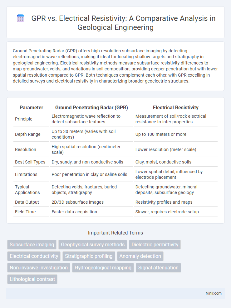
Table of Comparison
| Parameter | Ground Penetrating Radar (GPR) | Electrical Resistivity |
|---|---|---|
| Principle | Electromagnetic wave reflection to detect subsurface features | Measurement of soil/rock electrical resistance to infer properties |
| Depth Range | Up to 30 meters (varies with soil conditions) | Up to 100 meters or more |
| Resolution | High spatial resolution (centimeter scale) | Lower resolution (meter scale) |
| Best Soil Types | Dry, sandy, and non-conductive soils | Clay, moist, conductive soils |
| Limitations | Poor penetration in clay or saline soils | Lower spatial detail, influenced by electrode placement |
| Typical Applications | Detecting voids, fractures, buried objects, stratigraphy | Detecting groundwater, mineral deposits, subsurface geology |
| Data Output | 2D/3D subsurface images | Resistivity profiles and maps |
| Field Time | Faster data acquisition | Slower, requires electrode setup |
Introduction to Geophysical Methods in Geological Engineering
Ground Penetrating Radar (GPR) and electrical resistivity are essential geophysical methods used in geological engineering for subsurface characterization. GPR utilizes high-frequency electromagnetic waves to detect changes in material properties and is effective for identifying shallow structures and stratigraphy. Electrical resistivity measures the subsurface resistance to electrical current, providing detailed information on lithology, groundwater presence, and contaminant plumes by mapping resistivity contrasts in soil and rock.
Overview of Ground Penetrating Radar (GPR)
Ground Penetrating Radar (GPR) is a geophysical method using high-frequency electromagnetic waves to detect subsurface structures by measuring reflected signals from material boundaries. GPR provides high-resolution imaging of shallow subsurface features, making it ideal for applications like utility mapping, archaeology, and environmental assessments. Unlike electrical resistivity, which measures soil resistivity through current injection, GPR offers rapid, non-invasive data collection with detailed three-dimensional subsurface profiling.
Fundamentals of Electrical Resistivity Techniques
Electrical resistivity techniques measure subsurface properties by introducing an electrical current into the ground and recording the resulting potential differences, providing detailed information on the soil's or rock's resistivity variations. These methods rely on the principle that different materials exhibit distinct resistivity values influenced by factors such as moisture content, porosity, and mineralization. Ground Penetrating Radar (GPR), in contrast, uses electromagnetic wave reflections to detect subsurface features but typically offers higher resolution in shallow, dry conditions compared to resistivity surveys that excel in identifying deeper or more conductive anomalies.
Principles of Operation: GPR vs Electrical Resistivity
Ground Penetrating Radar (GPR) operates by emitting high-frequency electromagnetic waves into the subsurface and measuring the reflected signals from material boundaries to detect variations in dielectric permittivity. Electrical Resistivity surveys inject electrical current into the ground and measure the resulting potential differences to determine subsurface resistivity contrasts associated with different materials and moisture content. GPR provides high-resolution imaging of shallow structures, while electrical resistivity excels in mapping deeper resistivity variations, making both complementary in geophysical investigations.
Applications of GPR in Geological Investigations
Ground Penetrating Radar (GPR) excels in geological investigations by providing high-resolution images of subsurface structures, detecting stratigraphic features, and mapping soil layering with precision. Unlike electrical resistivity methods, which measure subsurface resistivity variations to infer geological properties, GPR directly captures reflected radar signals from material boundaries, making it ideal for locating voids, fractures, and shallow bedrock. This technology is extensively applied in mining exploration, groundwater studies, and archaeological surveys to quickly identify and characterize subsurface anomalies.
Electrical Resistivity Uses in Subsurface Characterization
Electrical resistivity methods provide detailed insight into subsurface characterization by measuring the resistance of soil and rock to electrical current, which helps identify variations in moisture content, porosity, and mineral composition. This technique is widely used for groundwater exploration, contamination mapping, and detecting subsurface voids or fractures. Compared to Ground Penetrating Radar (GPR), electrical resistivity is more effective in highly conductive or clay-rich environments where radar signal penetration is limited.
Data Resolution and Depth of Penetration Comparison
Ground Penetrating Radar (GPR) provides higher data resolution with centimeter-scale imaging, ideal for detecting small or shallow subsurface features. Electrical Resistivity Tomography (ERT) offers greater depth penetration, often reaching tens of meters depending on electrode spacing and soil conditions, but with lower spatial resolution compared to GPR. The choice between GPR and ERT depends on the target depth and required detail, balancing GPR's fine resolution against ERT's deeper subsurface imaging capabilities.
Advantages and Limitations: GPR vs Electrical Resistivity
Ground Penetrating Radar (GPR) offers high-resolution imaging and rapid data acquisition, making it ideal for detecting shallow subsurface features such as utilities, voids, and stratigraphy in dry, non-conductive materials. Electrical Resistivity, on the other hand, excels in mapping deeper subsurface conditions and groundwater investigations, particularly in conductive soils where GPR signal attenuation is significant. Limitations include GPR's reduced penetration depth in clay-rich or saline environments and Electrical Resistivity's lower resolution and longer survey times, requiring careful site-specific method selection for optimal geophysical results.
Case Studies: Practical Examples in Geological Engineering
Ground Penetrating Radar (GPR) and Electrical Resistivity Tomography (ERT) are extensively applied in geological engineering case studies to identify subsurface features such as fractures, voids, and groundwater contamination. GPR excels in high-resolution imaging of shallow, non-conductive materials, demonstrated in urban infrastructure assessments and archaeological site investigations. ERT provides detailed resistivity distribution profiles effective in characterizing heterogeneity in clayey soils, mining exploration, and detecting contaminant plumes in environmental remediation projects.
Choosing the Right Method for Geological Engineering Projects
Ground Penetrating Radar (GPR) excels in detecting shallow subsurface features with high-resolution imaging, making it ideal for mapping utilities and stratigraphy in non-clay soils. Electrical Resistivity Tomography (ERT) provides deeper penetration and better characterization of geological structures in varied soil types, especially useful for groundwater studies and contamination assessments. Selecting between GPR and ERT depends on project depth requirements, soil conductivity, and the specific geological information needed for engineering design.
Subsurface imaging
Ground Penetrating Radar (GPR) offers higher-resolution subsurface imaging by detecting reflected electromagnetic waves, while electrical resistivity imaging provides deeper penetration by measuring soil and rock resistivity variations.
Geophysical survey methods
GPR provides high-resolution subsurface imaging using electromagnetic waves optimal for shallow, dry environments, while electrical resistivity surveys measure subsurface resistance to electrical current, excelling in detecting variations in moisture content and soil composition at greater depths.
Dielectric permittivity
Ground Penetrating Radar (GPR) exploits variations in dielectric permittivity to detect subsurface features, while electrical resistivity methods measure the ground's resistance to electric current, offering complementary insights into soil properties and moisture content.
Electrical conductivity
Electrical conductivity in electrical resistivity surveys provides precise subsurface material characterization by measuring current flow, while GPR relies on electromagnetic wave reflections, making electrical resistivity more effective in detecting variations in soil moisture and mineral content.
Stratigraphic profiling
Ground Penetrating Radar (GPR) provides high-resolution stratigraphic profiling by detecting dielectric contrasts, while electrical resistivity offers deeper subsurface imaging through variations in soil conductivity.
Anomaly detection
Ground Penetrating Radar (GPR) provides higher resolution imaging for detecting shallow subsurface anomalies, whereas electrical resistivity excels in identifying deeper resistivity contrasts, making GPR optimal for detailed anomaly mapping and resistivity methods better suited for broad geological anomaly detection.
Non-invasive investigation
Ground Penetrating Radar (GPR) provides higher-resolution, non-invasive subsurface imaging compared to electrical resistivity methods, making it more effective for detailed geophysical investigations without soil disturbance.
Hydrogeological mapping
Ground Penetrating Radar (GPR) provides high-resolution subsurface imaging for shallow hydrogeological mapping, while Electrical Resistivity Tomography (ERT) offers deeper penetration and better identification of aquifer boundaries and groundwater flow paths.
Signal attenuation
Signal attenuation in Ground Penetrating Radar (GPR) is significantly influenced by soil moisture and conductivity, resulting in decreased penetration depth compared to Electrical Resistivity methods, which are less affected by signal loss and provide better subsurface imaging in highly conductive or saturated soils.
Lithological contrast
Ground Penetrating Radar (GPR) provides high-resolution imaging sensitive to lithological contrasts by detecting dielectric permittivity variations, while Electrical Resistivity primarily maps subsurface lithology variations based on differences in electrical conductivity, making GPR more effective in detecting fine-scale lithological boundaries in dry, non-conductive materials.
GPR vs electrical resistivity Infographic