Remote sensing offers rapid, large-scale geological data acquisition by using satellite or aerial imagery, enhancing the identification of terrain features and mineral deposits with high accuracy. Traditional surveying provides detailed, ground-truth measurements essential for precise topographic mapping and site-specific engineering assessments. Combining remote sensing with traditional surveying techniques optimizes geological analysis by integrating broad spatial coverage with exact local data.
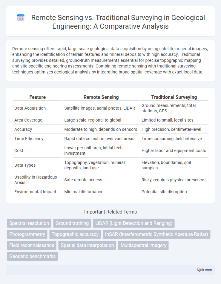
Table of Comparison
| Feature | Remote Sensing | Traditional Surveying |
|---|---|---|
| Data Acquisition | Satellite images, aerial photos, LiDAR | Ground measurements, total stations, GPS |
| Area Coverage | Large-scale, regional to global | Limited to small, local sites |
| Accuracy | Moderate to high, depends on sensors | High precision, centimeter-level |
| Time Efficiency | Rapid data collection over vast areas | Time-consuming, field intensive |
| Cost | Lower per unit area, initial tech investment | Higher labor and equipment costs |
| Data Types | Topography, vegetation, mineral deposits, land use | Elevation, boundaries, soil samples |
| Usability in Hazardous Areas | Safe remote access | Risky, requires physical presence |
| Environmental Impact | Minimal disturbance | Potential site disruption |
Introduction to Geological Surveying Methods
Remote sensing employs satellite imagery and aerial data to analyze geological features, enabling large-scale and inaccessible area surveys with high spatial resolution. Traditional surveying relies on ground-based measurements using tools like theodolites and total stations, offering precise, localized data critical for detailed geological mapping. Integrating both methods enhances the accuracy and efficiency of geological surveying by combining broad observational coverage with precise ground verification.
Overview of Traditional Surveying Techniques
Traditional surveying techniques rely on ground-based methods such as theodolites, total stations, and leveling instruments to measure distances, angles, and elevations with high precision. These techniques require physical access to the site and involve labor-intensive processes, making them time-consuming for large or inaccessible areas. Despite limitations, traditional surveying remains essential for detailed topographic mapping, construction layout, and boundary determination where sub-centimeter accuracy is required.
Evolution and Principles of Remote Sensing
Remote sensing has evolved from early aerial photography to advanced satellite imaging, enabling large-scale data acquisition without physical contact. It operates on the principle of detecting and measuring electromagnetic radiation reflected or emitted from Earth's surface, offering multispectral, hyperspectral, and temporal resolution advantages over traditional surveying. Traditional surveying relies on direct ground measurements and physical markers, whereas remote sensing integrates sensor technology, digital image processing, and geospatial analysis to enhance accuracy and efficiency in mapping and environmental monitoring.
Key Technologies in Remote Sensing for Geology
Remote sensing for geology relies heavily on advanced technologies such as multispectral and hyperspectral imaging, LiDAR (Light Detection and Ranging), and Synthetic Aperture Radar (SAR) to capture detailed earth surface data. These technologies enable precise mineral identification, fault mapping, and terrain analysis by capturing data beyond the visible spectrum and providing three-dimensional topographic information. In contrast, traditional surveying methods primarily depend on manual measurements and ground-based instruments like theodolites and total stations, which offer limited spatial coverage and lower resolution compared to remote sensing techniques.
Accuracy Comparison: Remote Sensing vs Traditional Surveying
Remote sensing technology offers increased spatial coverage and faster data acquisition compared to traditional surveying, yet its accuracy can vary based on sensor type and environmental conditions. Traditional surveying methods, such as total station and GPS, deliver higher precision and reliability in localized measurements, often achieving centimeter-level accuracy. Integrating remote sensing data with ground-based surveys enhances overall accuracy by compensating for limitations inherent in both approaches.
Cost and Time Efficiency in Geological Data Collection
Remote sensing significantly reduces geological data collection costs by minimizing the need for extensive fieldwork and manpower compared to traditional surveying methods. It accelerates data acquisition over large and inaccessible areas through satellite imagery and UAV-based sensors, cutting down project timelines dramatically. Traditional surveying, while precise, often requires more time and higher labor expenses due to on-site measurements and equipment transport.
Applications in Terrain Analysis and Mapping
Remote sensing offers large-scale, high-resolution terrain analysis by utilizing satellite imagery and aerial photography, enabling efficient mapping of inaccessible or extensive areas. Traditional surveying provides precise, ground-based measurements essential for detailed topographic maps and infrastructure planning in localized regions. Integrating remote sensing with traditional surveying enhances accuracy and efficiency in terrain mapping across diverse environments.
Data Resolution and Limitations of Each Method
Remote sensing offers high spatial resolution through satellite or aerial imagery, enabling large-area coverage with data often ranging from sub-meter to several meters resolution. Traditional surveying provides precise, ground-based measurements with higher positional accuracy but limited spatial extent and slower data acquisition. Remote sensing may suffer from atmospheric interference and lower temporal resolution, while traditional surveying is labor-intensive and constrained by terrain accessibility.
Environmental Impact and Accessibility
Remote sensing significantly reduces environmental impact by minimizing ground disturbance and avoiding habitat destruction, unlike traditional surveying methods that often require extensive physical access and land alteration. Remote sensing technologies, such as satellite imagery and aerial drones, provide accessible data collection over large and difficult-to-reach areas, enhancing survey efficiency in remote or hazardous environments. Traditional surveying methods depend heavily on on-site measurements, which can be limited by terrain accessibility and pose greater risks to sensitive ecosystems.
Future Trends in Geological Surveying Technologies
Remote sensing technologies, such as LiDAR and hyperspectral imaging, are transforming geological surveying by enabling faster data acquisition over extensive and inaccessible terrains compared to traditional surveying methods reliant on manual measurements and ground-based observations. The integration of artificial intelligence and machine learning algorithms with remote sensing data is driving future trends, enhancing the accuracy of geological feature detection and mineral exploration. Advancements in unmanned aerial vehicles (UAVs) equipped with high-resolution sensors are expected to further revolutionize geological surveys by providing cost-effective, real-time mapping and monitoring capabilities.
Spectral resolution
Remote sensing offers higher spectral resolution by capturing data across multiple wavelength bands, enabling detailed material identification compared to the limited spectral range of traditional surveying methods.
Ground truthing
Ground truthing in remote sensing involves validating satellite or aerial data with precise on-site measurements, whereas traditional surveying relies primarily on direct, in-field data collection for accurate spatial information.
LiDAR (Light Detection and Ranging)
LiDAR remote sensing provides precise 3D terrain mapping and vegetation analysis with higher accuracy and faster data acquisition compared to traditional surveying methods relying on manual measurements.
Photogrammetry
Photogrammetry in remote sensing enables faster, more accurate 3D terrain mapping and data acquisition compared to traditional surveying methods reliant on manual measurements and ground control points.
Topographic accuracy
Remote sensing provides higher topographic accuracy by capturing detailed elevation data over large areas quickly, whereas traditional surveying offers precise but localized measurements through ground-based instruments.
InSAR (Interferometric Synthetic Aperture Radar)
InSAR in remote sensing provides high-precision, large-scale ground deformation measurements with millimeter accuracy, surpassing the localized and labor-intensive data collection methods of traditional surveying.
Field reconnaissance
Remote sensing enhances field reconnaissance by providing aerial and satellite imagery for extensive data collection, while traditional surveying relies on direct ground measurements and manual observations for localized accuracy.
Spatial data interpolation
Remote sensing provides extensive spatial data interpolation through satellite imagery and sensor grids, offering higher accuracy and broader coverage compared to traditional surveying methods reliant on limited ground-based measurements.
Multispectral imagery
Multispectral imagery in remote sensing provides precise, large-scale environmental data collection far beyond the limited spatial scope and manual effort of traditional surveying methods.
Geodetic benchmarks
Remote sensing provides rapid, high-accuracy geodetic benchmark data over large areas compared to traditional surveying methods that require extensive fieldwork and are limited by accessibility and time constraints.
Remote sensing vs Traditional surveying Infographic