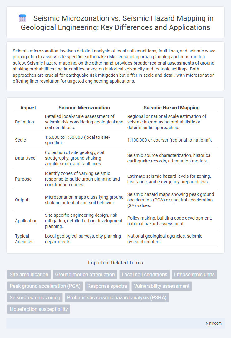
Seismic microzonation involves detailed analysis of local soil conditions, fault lines, and seismic wave propagation to assess site-specific earthquake risks, enhancing urban planning and construction safety. Seismic hazard mapping, on the other hand, provides broader regional assessments of ground shaking probabilities and intensities based on historical seismicity and tectonic settings. Both approaches are crucial for earthquake risk mitigation but differ in scale and detail, with microzonation offering finer resolution for targeted engineering applications.
Table of Comparison
| Aspect | Seismic Microzonation | Seismic Hazard Mapping |
|---|---|---|
| Definition | Detailed local-scale assessment of seismic risk considering geological and soil conditions. | Regional or national scale estimation of seismic hazard using probabilistic or deterministic approaches. |
| Scale | 1:5,000 to 1:50,000 (local to site-specific). | 1:100,000 or coarser (regional to national). |
| Data Used | Collection of site geology, soil stratigraphy, ground shaking amplification, and fault lines. | Seismic source characterization, historical earthquake records, attenuation models. |
| Purpose | Identify zones of varying seismic response to guide urban planning and construction codes. | Estimate seismic hazard levels for zoning, insurance, and emergency preparedness. |
| Output | Microzonation maps classifying ground shaking potential and soil behavior. | Seismic hazard maps showing peak ground acceleration (PGA) or spectral acceleration (SA) values. |
| Application | Site-specific engineering design, risk mitigation, detailed urban development planning. | Policy making, building code development, national hazard assessment. |
| Typical Agencies | Local geological surveys, city planning departments. | National geological agencies, seismic research centers. |
Introduction to Seismic Microzonation and Seismic Hazard Mapping
Seismic microzonation involves detailed analysis of local soil conditions, geology, and seismic wave propagation to identify specific areas within a region that may experience varying levels of shaking during an earthquake. Seismic hazard mapping provides a broader-scale evaluation of earthquake risk by estimating ground shaking intensity and probability across larger geographic regions using historical seismicity, fault data, and ground motion prediction models. Both approaches are essential for earthquake risk mitigation, with microzonation offering granular insights for urban planning and engineering design, while hazard mapping supports regional risk assessment and disaster preparedness.
Fundamental Concepts: Definitions and Objectives
Seismic microzonation involves detailed geographic assessment to identify local variations in seismic risk, focusing on soil characteristics, geological conditions, and their effects on ground shaking. Seismic hazard mapping provides a broader regional overview of earthquake probabilities and expected ground motion intensity, aiming to inform urban planning and disaster preparedness. Both approaches serve the objective of minimizing earthquake impact but operate at different spatial scales and analytical depths.
Methodological Approaches: Microzonation vs Hazard Mapping
Seismic microzonation employs detailed geotechnical and geophysical surveys to assess site-specific ground response, emphasizing local soil conditions and seismic wave amplification for precise risk delineation. Seismic hazard mapping utilizes probabilistic seismic hazard analysis (PSHA) or deterministic seismic hazard analysis (DSHA) to estimate ground motion parameters over broader regions, integrating earthquake catalogues, fault slip rates, and attenuation relationships. The methodological framework of microzonation is granular and site-centric, whereas hazard mapping adopts a comprehensive, region-wide probabilistic model to inform building codes and land-use planning.
Data Requirements and Sources for Each Method
Seismic microzonation requires high-resolution geological, geotechnical, and geophysical data such as soil profiles, borehole logs, and local seismicity records to assess site-specific ground behavior during earthquakes. Seismic hazard mapping depends on broader-scale data including regional seismicity catalogs, fault distribution, historical earthquake records, and attenuation relationships to estimate ground shaking intensity probabilities across large areas. While microzonation emphasizes detailed local data for precise ground response modeling, hazard mapping synthesizes regional seismic sources and probabilistic models to provide generalized risk assessments.
Spatial Resolution: Local vs Regional Assessments
Seismic microzonation provides high spatial resolution by analyzing local geological, geotechnical, and seismic data to identify variations in seismic hazards within small urban areas or neighborhoods. In contrast, seismic hazard mapping offers a broader, regional assessment of seismic risks based on regional fault activity and ground shaking probabilities, with less detailed spatial granularity. This localized approach in microzonation supports targeted seismic design and risk reduction, whereas regional hazard maps guide large-scale planning and emergency preparedness.
Applications in Urban Planning and Infrastructure Design
Seismic microzonation offers detailed local ground shaking data, critical for urban planners to identify vulnerable zones and design earthquake-resilient infrastructure. Seismic hazard mapping provides broader regional seismic risk assessments, guiding zoning regulations and land-use planning to mitigate earthquake damage. Integrating both methods enhances urban safety by tailoring construction standards and emergency preparedness to site-specific seismic risks.
Advantages and Limitations of Seismic Microzonation
Seismic microzonation offers detailed ground-level assessments by subdividing a region into smaller zones based on local geological, seismological, and geotechnical conditions, which enhances the accuracy of earthquake risk evaluations compared to broader seismic hazard mapping. It provides critical data for urban planning and infrastructure design, reducing seismic risk in densely populated areas by considering site-specific factors such as soil type, ground motion amplification, and liquefaction potential. However, seismic microzonation requires extensive field data, significant technical expertise, and substantial financial investment, limiting its widespread application in resource-constrained regions and often resulting in longer implementation timelines.
Benefits and Constraints of Seismic Hazard Mapping
Seismic hazard mapping identifies regions with varying probabilities of earthquake occurrences, enabling urban planners and engineers to design structures that withstand expected seismic forces, which enhances public safety and reduces economic losses. The benefits include providing a broad overview of seismic risks, facilitating risk-informed decision-making, and guiding construction codes across large areas. Constraints involve limited resolution that may overlook localized variations in ground shaking, dependence on historical seismic data that can be incomplete, and uncertainties in predicting future seismic events.
Case Studies: Comparative Outcomes in Geological Engineering
Seismic microzonation provides detailed ground shaking variations within small areas, essential for urban planning and structural design, while seismic hazard mapping offers broader regional risk assessments. Case studies in geological engineering reveal that microzonation enables more precise mitigation strategies by incorporating local soil conditions and fault proximity, resulting in reduced infrastructural damage. Comparative outcomes demonstrate that integrating both approaches enhances seismic resilience by balancing macro-scale hazard identification with micro-scale ground response analysis.
Integrating Seismic Microzonation and Hazard Mapping for Risk Reduction
Seismic microzonation provides detailed, site-specific assessments of soil and geological conditions influencing local earthquake effects, while seismic hazard mapping offers broader regional estimates of earthquake intensities and probabilities. Integrating seismic microzonation with hazard mapping enhances risk reduction by combining macro-level hazard probabilities with fine-scale ground response variations, enabling targeted mitigation strategies. This integrated approach supports urban planning, engineering design, and emergency response, optimizing resource allocation and improving community resilience against seismic events.
Site amplification
Seismic microzonation provides detailed site amplification assessments by analyzing localized soil conditions, whereas seismic hazard mapping offers broader regional estimates without specific amplification factors.
Ground motion attenuation
Seismic microzonation provides detailed ground motion attenuation models tailored to local soil and geological conditions, whereas seismic hazard mapping offers broader regional ground motion attenuation estimates based on generalized seismic source characteristics.
Local soil conditions
Seismic microzonation provides detailed assessments of local soil conditions to identify site-specific earthquake effects, whereas seismic hazard mapping offers broader regional estimates of seismic risk without precise soil condition analysis.
Lithoseismic units
Seismic microzonation provides detailed lithoseismic unit classification essential for localized earthquake risk assessment, while seismic hazard mapping offers broader regional seismic intensity predictions without granular lithoseismic differentiation.
Peak ground acceleration (PGA)
Seismic microzonation provides detailed Peak Ground Acceleration (PGA) variations within localized areas, whereas seismic hazard mapping offers broader region-wide PGA estimates for overall earthquake risk assessment.
Response spectra
Seismic microzonation provides site-specific Response spectra essential for detailed earthquake engineering, while Seismic hazard mapping offers broader regional Response spectra primarily for preliminary risk assessment.
Vulnerability assessment
Seismic microzonation provides detailed local geological and soil condition data crucial for accurate vulnerability assessment, whereas seismic hazard mapping offers broader regional seismic risk estimates essential for preliminary vulnerability analysis.
Seismotectonic zoning
Seismic microzonation provides detailed local seismic risk assessments by integrating seismotectonic zoning, while seismic hazard mapping offers broader regional earthquake probability estimates.
Probabilistic seismic hazard analysis (PSHA)
Probabilistic seismic hazard analysis (PSHA) quantitatively estimates earthquake hazard levels over a region, forming the foundation for seismic hazard mapping, while seismic microzonation integrates PSHA results with local geological and site conditions to produce detailed, spatially resolved seismic risk assessments.
Liquefaction susceptibility
Seismic microzonation provides detailed localized assessments of liquefaction susceptibility by analyzing soil characteristics and ground conditions, whereas seismic hazard mapping offers broader regional evaluations of seismic risks including liquefaction potential.
Seismic microzonation vs Seismic hazard mapping Infographic