Spatial variability in geological engineering highlights the differences in material properties and geological features across a given area, impacting site investigation accuracy and design reliability. Scale effect refers to how the observed properties and behaviors of geological materials can change depending on the size of the sample or study area, influencing the interpretation of data and the prediction of ground behavior. Understanding the interplay between spatial variability and scale effect is essential for developing robust models and ensuring safe engineering solutions in complex geological environments.
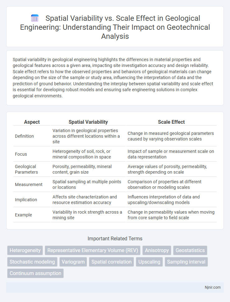
Table of Comparison
| Aspect | Spatial Variability | Scale Effect |
|---|---|---|
| Definition | Variation in geological properties across different locations within a site | Change in measured geological parameters caused by varying observation scales |
| Focus | Heterogeneity of soil, rock, or mineral composition in space | Impact of sample or measurement scale on data representation |
| Geological Parameters | Porosity, permeability, mineral content, grain size | Average values of porosity, permeability, strength depending on scale |
| Measurement | Spatial sampling at multiple points or locations | Comparison of properties at different observation or modeling scales |
| Implication | Affects site characterization and resource estimation accuracy | Influences interpretation of data and upscaling/downscaling models |
| Example | Variability in rock strength across a mining site | Change in permeability values when moving from core sample to field scale |
Understanding Spatial Variability in Geological Engineering
Spatial variability in geological engineering refers to the natural heterogeneity of soil and rock properties that change over different locations, significantly impacting site characterization and design. The scale effect influences the observed variability since measurements taken at smaller scales often reveal more detail and heterogeneity, while larger-scale assessments average out these variations, affecting the reliability of geological models. Accurate understanding of spatial variability and scale effects enables better risk assessment, foundation design, and resource estimation in complex geological settings.
Defining Scale Effect: Concepts and Importance
Scale effect refers to the changes in data patterns or statistical relationships observed when measurements are taken at different spatial resolutions or extents. It highlights how spatial variability manifests differently depending on the scale, influencing the interpretation and modeling of geographic phenomena. Understanding the scale effect is crucial for accurate spatial analysis, ensuring that conclusions drawn are appropriate for the scale of study and improving decision-making in fields such as ecology, geology, and urban planning.
Relationships Between Spatial Variability and Scale Effect
Spatial variability refers to the variation in a phenomenon across different locations, while scale effect describes how measurements or observations change when the spatial resolution or extent is altered. The relationship between spatial variability and scale effect is critical, as increasing the spatial scale often aggregates fine-scale variations, potentially masking local heterogeneity and altering statistical properties such as variance and correlation. Understanding this relationship improves modeling accuracy in fields like geostatistics, environmental science, and remote sensing by optimizing scale selection for spatial data analysis.
Measurement Techniques for Spatial Variability
Measurement techniques for spatial variability include geostatistical methods such as variogram analysis and kriging, which capture spatial dependence and quantify heterogeneity at different scales. Remote sensing and GIS provide high-resolution spatial data that enhance understanding of variability patterns, enabling multi-scale analysis. Sampling strategies must consider scale effects to optimize accuracy, balancing sample density with spatial extent to accurately represent variability in environmental or geological studies.
Quantitative Methods to Assess Scale Effect
Quantitative methods to assess the scale effect in spatial variability include geostatistical techniques such as variograms and semivariograms that measure spatial dependence across multiple scales. Multiscale analysis tools like wavelet transforms and fractal analysis quantify how spatial patterns and heterogeneity change with varying spatial resolutions. Scale effect assessment leverages spatial autocorrelation metrics and spatial sampling strategies to optimize data aggregation and model accuracy in fields such as ecology, hydrology, and environmental science.
Impact of Spatial Variability on Engineering Design
Spatial variability significantly influences engineering design by dictating the heterogeneity of soil properties, rock formations, and environmental conditions across a project site. Understanding scale effects allows engineers to accurately characterize site-specific parameters, adjusting models to reflect changes in material behavior or load responses at different spatial resolutions. Incorporating spatial variability ensures optimized safety factors, cost efficiency, and reliability in foundation design, slope stability assessments, and infrastructure resilience.
Scale Effect in Laboratory vs. Field Testing
Scale effect significantly influences the accuracy of soil property measurements, with laboratory testing often limited by small sample sizes that may not capture natural heterogeneity. Field testing incorporates larger spatial scales, reflecting true variability and providing more representative results for geotechnical and environmental assessments. Understanding scale effect differences between laboratory and field conditions is critical for reliable modeling and engineering design.
Statistical Tools for Analyzing Spatial Data
Statistical tools such as semivariograms and Moran's I quantify spatial variability by measuring the degree of spatial autocorrelation at varying distances, capturing how data similarity decreases with distance. Scale effects arise when spatial patterns observed at one resolution or extent change at another, necessitating multiscale analysis techniques like wavelet transforms and multi-resolution analysis to detect spatial heterogeneity across scales. Geostatistical methods and spatial regression models enable researchers to distinguish intrinsic spatial variability from scale-induced artifacts, improving accuracy in environmental modeling and resource management.
Case Studies: Spatial Variability and Scale Effect in Practice
Case studies on spatial variability and scale effect reveal how differences in data patterns emerge at varying spatial resolutions, influencing environmental modeling accuracy. For example, soil moisture data collected at fine scales often show high variability that diminishes when aggregated to coarser scales, affecting hydrological model predictions. Understanding these scale-dependent changes enhances decision-making in land management and resource allocation.
Challenges and Future Directions in Addressing Scale Effect
Addressing the scale effect in spatial variability involves overcoming challenges such as data resolution inconsistencies, multiscale heterogeneity, and the modifiable areal unit problem (MAUP). Future directions emphasize developing advanced geostatistical models and machine learning algorithms that integrate multiscale data to enhance predictive accuracy and generalizability. Improving remote sensing technologies and deploying high-resolution spatial datasets will further enable precise analysis of scale-dependent spatial patterns.
Heterogeneity
Spatial variability highlights heterogeneity at localized levels, while scale effect reveals how heterogeneity patterns change or diminish as the observational scale expands.
Representative Elementary Volume (REV)
Representative Elementary Volume (REV) defines the minimum sample volume at which spatial variability stabilizes, enabling accurate scale-up of heterogeneous properties in porous media analysis.
Anisotropy
Anisotropy reveals how spatial variability changes directionally, significantly influencing the scale effect in geostatistical modeling and spatial analysis.
Geostatistics
Geostatistics quantifies spatial variability by analyzing data patterns at multiple scales to improve predictions and model accuracy.
Stochastic modeling
Stochastic modeling captures spatial variability by quantifying scale effects through probabilistic distributions that adapt to different sampling resolutions and heterogeneity scales.
Variogram
The variogram quantifies spatial variability by measuring how data similarity decreases with increasing spatial lag, revealing scale effects that influence the interpretation of spatial patterns across different distances.
Spatial correlation
Spatial correlation quantifies the degree to which spatial variability changes with scale, highlighting how spatial patterns become more or less similar as the observation unit size increases.
Upscaling
Upscaling addresses spatial variability by aggregating fine-scale data to larger scales, reducing local heterogeneity effects while preserving essential landscape patterns for accurate regional analysis.
Sampling interval
Sampling interval critically influences spatial variability analysis by determining the resolution at which spatial patterns are detected and the scale effect on data accuracy.
Continuum assumption
The continuum assumption simplifies spatial variability analysis by treating heterogeneous materials as homogeneous at a given scale, highlighting how scale effects influence the interpretation of spatial data.
spatial variability vs scale effect Infographic