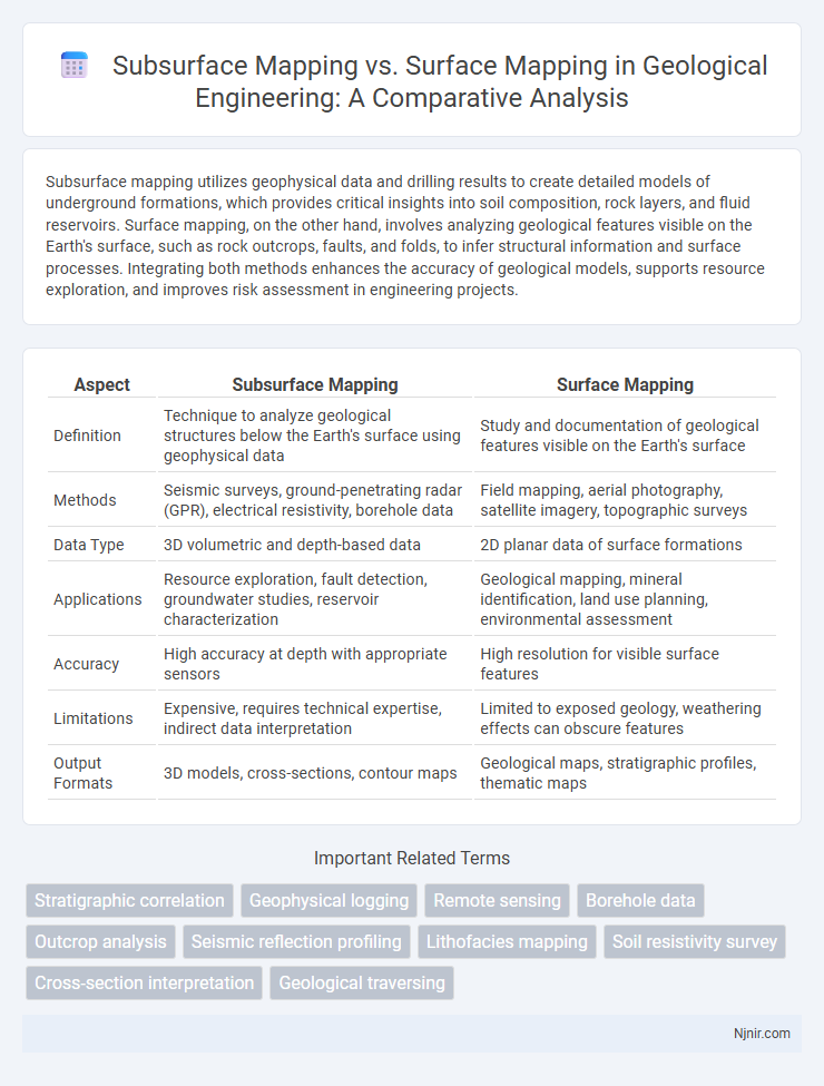
Subsurface mapping utilizes geophysical data and drilling results to create detailed models of underground formations, which provides critical insights into soil composition, rock layers, and fluid reservoirs. Surface mapping, on the other hand, involves analyzing geological features visible on the Earth's surface, such as rock outcrops, faults, and folds, to infer structural information and surface processes. Integrating both methods enhances the accuracy of geological models, supports resource exploration, and improves risk assessment in engineering projects.
Table of Comparison
| Aspect | Subsurface Mapping | Surface Mapping |
|---|---|---|
| Definition | Technique to analyze geological structures below the Earth's surface using geophysical data | Study and documentation of geological features visible on the Earth's surface |
| Methods | Seismic surveys, ground-penetrating radar (GPR), electrical resistivity, borehole data | Field mapping, aerial photography, satellite imagery, topographic surveys |
| Data Type | 3D volumetric and depth-based data | 2D planar data of surface formations |
| Applications | Resource exploration, fault detection, groundwater studies, reservoir characterization | Geological mapping, mineral identification, land use planning, environmental assessment |
| Accuracy | High accuracy at depth with appropriate sensors | High resolution for visible surface features |
| Limitations | Expensive, requires technical expertise, indirect data interpretation | Limited to exposed geology, weathering effects can obscure features |
| Output Formats | 3D models, cross-sections, contour maps | Geological maps, stratigraphic profiles, thematic maps |
Overview of Subsurface and Surface Mapping
Subsurface mapping involves the visualization and analysis of underground geological formations, utilizing techniques such as seismic surveys, ground-penetrating radar (GPR), and borehole data to detect structures like aquifers, oil reservoirs, and fault lines. Surface mapping focuses on creating detailed representations of the Earth's surface features, including topography, vegetation, and built environments, often employing remote sensing technologies, GIS, and aerial photography. Both mapping methods are essential for applications in natural resource exploration, environmental monitoring, and infrastructure development, with subsurface mapping providing critical data beneath the ground and surface mapping offering comprehensive spatial context above it.
Key Differences Between Subsurface and Surface Mapping
Subsurface mapping involves creating detailed representations of underground structures such as rock formations, water tables, and mineral deposits using techniques like seismic surveys and ground-penetrating radar, whereas surface mapping charts visible land features including topography, vegetation, and man-made structures primarily through aerial photography and satellite imagery. Key differences include the data acquisition methods, with subsurface mapping relying on indirect geophysical measurements and surface mapping utilizing direct visual and remote sensing technologies. Subsurface maps provide critical insights for fields like geology, mining, and oil exploration, while surface maps support urban planning, agriculture, and environmental monitoring.
Techniques Used in Subsurface Mapping
Subsurface mapping employs geophysical techniques such as seismic reflection, ground-penetrating radar (GPR), and electrical resistivity tomography (ERT) to visualize underground structures and identify variations in rock properties or fluid content. Unlike surface mapping, which relies heavily on direct observation and satellite imagery for topography and landforms, subsurface methods use wave propagation, electromagnetic fields, and electrical current to penetrate below the Earth's surface. Advanced data processing and interpretation of geophysical signals enable precise characterization of subsurface geology for applications in resource exploration, groundwater studies, and civil engineering.
Methods for Surface Mapping in Geological Engineering
Surface mapping in geological engineering primarily employs field observations, digital photogrammetry, and remote sensing techniques such as LiDAR and satellite imagery to capture detailed topographic and lithological data. These methods enable the creation of accurate geological maps by documenting rock outcrops, faults, and structural features directly visible on the Earth's surface. High-resolution GPS and drone surveys are increasingly integrated to enhance precision and spatial coverage in surface mapping projects.
Data Acquisition and Interpretation Processes
Subsurface mapping relies on geophysical methods like seismic reflection, ground-penetrating radar, and borehole data, allowing acquisition of three-dimensional data beneath the earth's surface for detailed stratigraphic and structural interpretation. Surface mapping primarily uses remote sensing, aerial photography, and direct field observations to capture topographic, geological, and geomorphological features visible on the earth's surface. Data interpretation in subsurface mapping integrates complex signal processing and inversion algorithms to model underground formations, whereas surface mapping interpretation emphasizes spatial analysis and correlation of surface lithologies and landforms.
Applications of Subsurface Mapping in Engineering Projects
Subsurface mapping provides critical data on underground geological formations, enabling engineers to assess soil stability, identify water tables, and detect potential hazards for construction projects. This information supports the design of foundations, tunnels, pipelines, and other infrastructure by ensuring safety and cost-effectiveness. Unlike surface mapping, which only captures terrain and surface features, subsurface mapping integrates geophysical surveys, drilling data, and seismic imaging to deliver a comprehensive understanding of underground conditions essential for successful engineering outcomes.
Roles of Surface Mapping in Site Characterization
Surface mapping plays a vital role in site characterization by providing detailed information on surface geology, including rock types, structures, and geomorphological features. This data helps identify potential hazards, guide sampling strategies, and establish correlations between surface and subsurface features. Compared to subsurface mapping, surface mapping offers rapid, cost-effective initial assessments that improve accuracy in site evaluation and decision-making processes.
Advantages and Limitations of Subsurface Mapping
Subsurface mapping provides detailed information about underground features such as soil layers, minerals, and groundwater, offering critical advantages for construction, environmental studies, and resource exploration by minimizing surface disruption. Its limitations include higher costs, technical complexity, and reduced resolution compared to surface mapping, which is often quicker and more cost-effective for mapping visible landforms and immediate environmental conditions. Despite these constraints, subsurface mapping enhances decision-making in engineering and geology by revealing hidden structures that surface mapping alone cannot detect.
Comparative Analysis: Subsurface vs Surface Mapping
Subsurface mapping provides detailed geological and structural information beneath the earth's surface using methods like seismic reflection, ground-penetrating radar, and electrical resistivity, enabling precise identification of mineral deposits, groundwater, and voids. Surface mapping captures visible landforms, soil types, and vegetation patterns through aerial photography, satellite imagery, and field surveys, offering broader spatial context but limited depth insight. The comparative analysis highlights subsurface mapping's superior accuracy in revealing underground features, while surface mapping excels in large-area environmental assessment and initial reconnaissance.
Future Trends in Geological Mapping Technologies
Subsurface mapping advances are increasingly driven by 3D seismic imaging, machine learning algorithms, and enhanced sensor integration, enabling more accurate detection of underground structures and resources. Surface mapping benefits from drone-based LiDAR, multispectral satellite imagery, and real-time data processing to create highly detailed topographic and environmental models. Future trends emphasize combining these technologies into integrated platforms for comprehensive geological analysis, improving exploration efficiency and risk management in natural resource industries.
Stratigraphic correlation
Stratigraphic correlation in subsurface mapping uses well logs and seismic data to identify and correlate rock layers below the surface, while surface mapping relies on outcrop observations and geomorphological features to establish geological relationships.
Geophysical logging
Geophysical logging provides detailed subsurface mapping by measuring physical properties within boreholes, offering more precise data than surface mapping techniques that rely on remote sensing or surface observations.
Remote sensing
Subsurface mapping using remote sensing leverages technologies like ground-penetrating radar and seismic waves to detect underground features, whereas surface mapping primarily employs satellite imagery and aerial photography to analyze land cover and topography.
Borehole data
Borehole data provides critical subsurface mapping insights by revealing underground geological structures that surface mapping alone cannot detect.
Outcrop analysis
Outcrop analysis in subsurface mapping reveals hidden geological structures and hydrocarbon reservoirs by examining rock exposures and fractures beneath the earth's surface, while surface mapping primarily documents visible landforms and surface geology.
Seismic reflection profiling
Seismic reflection profiling provides detailed subsurface mapping by analyzing reflected seismic waves to reveal geological structures, whereas surface mapping relies on visible land features and topography without penetrating below the Earth's surface.
Lithofacies mapping
Subsurface mapping utilizes geophysical and well log data to accurately delineate lithofacies distributions below the Earth's surface, while surface mapping relies on outcrop observations to interpret surface lithofacies variations.
Soil resistivity survey
Soil resistivity surveys provide critical data for subsurface mapping by measuring electrical resistance variations underground, enabling more accurate detection of soil layers and groundwater compared to surface mapping methods.
Cross-section interpretation
Cross-section interpretation in subsurface mapping provides detailed insights into geological formations below the surface, enabling accurate analysis of stratigraphy and structural features that surface mapping alone cannot reveal.
Geological traversing
Subsurface mapping uses geophysical data and drilling results to reveal underground geological structures, while surface mapping relies on direct observation of rock formations during geological traversing for accurate spatial analysis.
Subsurface mapping vs Surface mapping Infographic