Seismic microzonation provides detailed, localized assessments of soil and geological conditions that influence ground shaking intensity during earthquakes, allowing for precise hazard mitigation and urban planning. In contrast, seismic macrozonation offers broader, regional evaluations that identify general risk zones but lack the granularity needed for site-specific engineering decisions. Integrating microzonation into engineering practices enhances the accuracy of seismic risk analysis and improves the resilience of infrastructure against earthquake damage.
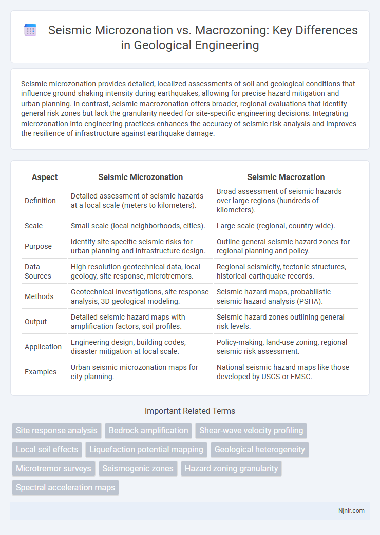
Table of Comparison
| Aspect | Seismic Microzonation | Seismic Macrozation |
|---|---|---|
| Definition | Detailed assessment of seismic hazards at a local scale (meters to kilometers). | Broad assessment of seismic hazards over large regions (hundreds of kilometers). |
| Scale | Small-scale (local neighborhoods, cities). | Large-scale (regional, country-wide). |
| Purpose | Identify site-specific seismic risks for urban planning and infrastructure design. | Outline general seismic hazard zones for regional planning and policy. |
| Data Sources | High-resolution geotechnical data, local geology, site response, microtremors. | Regional seismicity, tectonic structures, historical earthquake records. |
| Methods | Geotechnical investigations, site response analysis, 3D geological modeling. | Seismic hazard maps, probabilistic seismic hazard analysis (PSHA). |
| Output | Detailed seismic hazard maps with amplification factors, soil profiles. | Seismic hazard zones outlining general risk levels. |
| Application | Engineering design, building codes, disaster mitigation at local scale. | Policy-making, land-use zoning, regional seismic risk assessment. |
| Examples | Urban seismic microzonation maps for city planning. | National seismic hazard maps like those developed by USGS or EMSC. |
Introduction to Seismic Zonation in Geological Engineering
Seismic microzonation involves detailed mapping of local geological and geotechnical conditions to assess earthquake hazards at a neighborhood or site-specific level, whereas macrozonation provides broader regional seismic risk assessments based on tectonic settings and large-scale geological features. In geological engineering, seismic zonation supports hazard mitigation by identifying variations in ground shaking, soil amplification, and liquefaction potential critical for designing resilient infrastructure. Microzonation offers precise data for urban planning and foundation engineering, while macrozonation guides regional seismic codes and emergency preparedness strategies.
Fundamentals of Seismic Microzonation
Seismic microzonation involves detailed mapping of local soil and geological conditions to assess variations in seismic hazard within small urban areas, enhancing earthquake risk mitigation. It requires high-resolution data on seismic wave propagation, site amplification, and liquefaction potential compared to macrozonation, which classifies broader regions. Understanding site-specific ground motion parameters through microzonation is fundamental for informed urban planning, construction codes, and disaster preparedness.
Fundamentals of Seismic Macrozonation
Seismic macrozonation involves dividing a large geographic region into zones based on generalized seismic hazard levels, using broad geological and tectonic data to assess seismic risk. It primarily considers parameters such as seismic source characterization, historical earthquake records, and regional ground motion prediction, which underpin its fundamental approach. This method supports large-scale urban planning and policy-making but lacks the fine detail of microzonation essential for site-specific engineering design.
Key Differences Between Microzonation and Macrozonation
Seismic microzonation involves detailed mapping of ground shaking variations within small urban areas, incorporating local soil conditions, topography, and geological features, whereas seismic macrozonation covers broad regional seismic hazard assessments typically at the scale of entire cities or regions. Microzonation uses high-resolution data and advanced geotechnical investigations to guide building codes and land-use planning at a neighborhood level, while macrozonation provides a general framework for regional seismic risk management and emergency response planning. The precision in microzonation enables targeted mitigation strategies based on site-specific seismic parameters, contrasting with the broader, less detailed seismic intensity grading characteristic of macrozonation.
Data Requirements for Seismic Microzonation
Seismic microzonation requires detailed geological, geotechnical, and geophysical data, including soil profiles, topographic variations, and local fault lines, to assess site-specific seismic hazards accurately. This contrasts with seismic macrozonation, which relies on broader regional seismicity and tectonic settings, often using generalized seismic hazard maps. High-resolution data from borehole samples, geotechnical tests, and ground motion recordings are essential for effective seismic microzonation, enabling precise assessment of seismic risk within small urban or infrastructural areas.
Tools and Techniques for Macrozonation Analysis
Seismic macrozonation relies on broad-scale tools such as geological mapping, regional tectonic studies, and seismic hazard models that incorporate historical earthquake data and geophysical surveys to assess overall seismic risk. Remote sensing technologies, geographic information systems (GIS), and probabilistic seismic hazard analysis (PSHA) are crucial for evaluating regional seismic sources, ground shaking potential, and soil amplification effects across large areas. These techniques enable the creation of macroseismic maps that guide land-use planning and disaster management policies at national or regional levels.
Resolution and Scale in Seismic Zonation
Seismic microzonation offers high-resolution mapping that captures localized variations in soil properties, geology, and seismic response, typically at scales ranging from tens to a few hundred meters. In contrast, seismic macrozonation provides broader-scale assessments covering entire cities or regions, often at scales of several kilometers, emphasizing general seismic hazard trends rather than fine-grained site-specific details. The enhanced spatial resolution of microzonation is crucial for urban planning, infrastructure design, and disaster mitigation, enabling precise identification of seismic risk at the neighborhood or site level.
Applications and Use Cases in Urban Planning
Seismic microzonation provides detailed, site-specific assessments of ground shaking, liquefaction, and fault rupture hazards crucial for designing earthquake-resistant infrastructure in urban areas. In contrast, macrozonation offers broader regional seismic risk evaluations, guiding large-scale land use planning and infrastructure development priorities. Integrating microzonation data into urban planning enhances zoning regulations, emergency response strategies, and building codes to mitigate seismic risks effectively.
Challenges in Implementing Microzonation and Macrozonation
Seismic microzonation faces challenges such as the need for high-resolution geological and geotechnical data, complex site-specific seismic response analysis, and substantial financial and technical resources for detailed mapping. In contrast, macrozonation struggles with broader spatial generalizations that may overlook local variations, leading to less precise hazard assessment and potential underestimation of risk in heterogeneous regions. Both approaches require integration of multidisciplinary data and stakeholder collaboration, but microzonation demands more granular input and computational capacity to effectively guide local urban planning and construction practices.
Future Trends in Seismic Zonation Methods
Seismic microzonation incorporates high-resolution geological, geotechnical, and geophysical data to create detailed hazard maps, while macrozonation relies on broader regional seismicity and tectonic information. Future trends emphasize integrating machine learning algorithms with real-time sensor networks to enhance predictive accuracy and dynamic risk assessment in seismic zones. Enhanced 3D subsurface imaging and urban-scale simulations will drive more precise microzonation models, enabling targeted mitigation strategies for vulnerable infrastructure.
Site response analysis
Seismic microzonation provides detailed site response analysis by assessing local soil and geological conditions, whereas macrozonation offers broader regional seismic hazard assessments with less resolution on site-specific effects.
Bedrock amplification
Seismic microzonation provides detailed mapping of bedrock amplification effects at a local level, whereas macrozonation offers broader regional assessments with less precise amplification data.
Shear-wave velocity profiling
Seismic microzonation uses high-resolution shear-wave velocity profiling to assess local site effects, while macrozonation provides broader regional seismic hazard mapping with less detailed velocity data.
Local soil effects
Seismic microzonation provides detailed analysis of local soil effects to accurately assess earthquake ground motion variations, while macrozonation offers broader regional seismic hazard mapping with less precision on soil amplification factors.
Liquefaction potential mapping
Seismic microzonation provides detailed liquefaction potential mapping at a local scale by analyzing soil properties and groundwater conditions, whereas macrozonation offers broader regional assessments with less spatial resolution.
Geological heterogeneity
Seismic microzonation provides detailed assessments of geological heterogeneity at a local scale, enabling more precise earthquake risk analysis compared to broader, less detailed macrozonation.
Microtremor surveys
Seismic microzonation using microtremor surveys provides high-resolution site-specific data on soil response and seismic hazards, offering more precise ground motion predictions compared to broader macrozonation studies.
Seismogenic zones
Seismic microzonation provides detailed risk assessment within localized seismogenic zones by analyzing soil conditions and fault proximity, while macrozonation offers broader regional classifications based on large-scale seismic sources and general tectonic settings.
Hazard zoning granularity
Seismic microzonation provides detailed hazard zoning at the neighborhood level by analyzing local soil and geological conditions, while macrozonation offers broader regional hazard classifications with less granularity.
Spectral acceleration maps
Spectral acceleration maps in seismic microzonation provide detailed ground motion variations at a local scale, enhancing earthquake hazard assessment accuracy compared to broader, less detailed macrozonation maps.
seismic microzonation vs macrozonation Infographic