GIS mapping integrates spatial data to analyze geological formations and assess site conditions, enabling precise visualization of terrain structures and fault lines. Remote sensing collects data from satellite or aerial imagery, providing comprehensive surface information that aids in detecting mineral deposits and monitoring environmental changes. Combining GIS mapping with remote sensing enhances geological engineering projects by improving accuracy in resource management and hazard prevention.
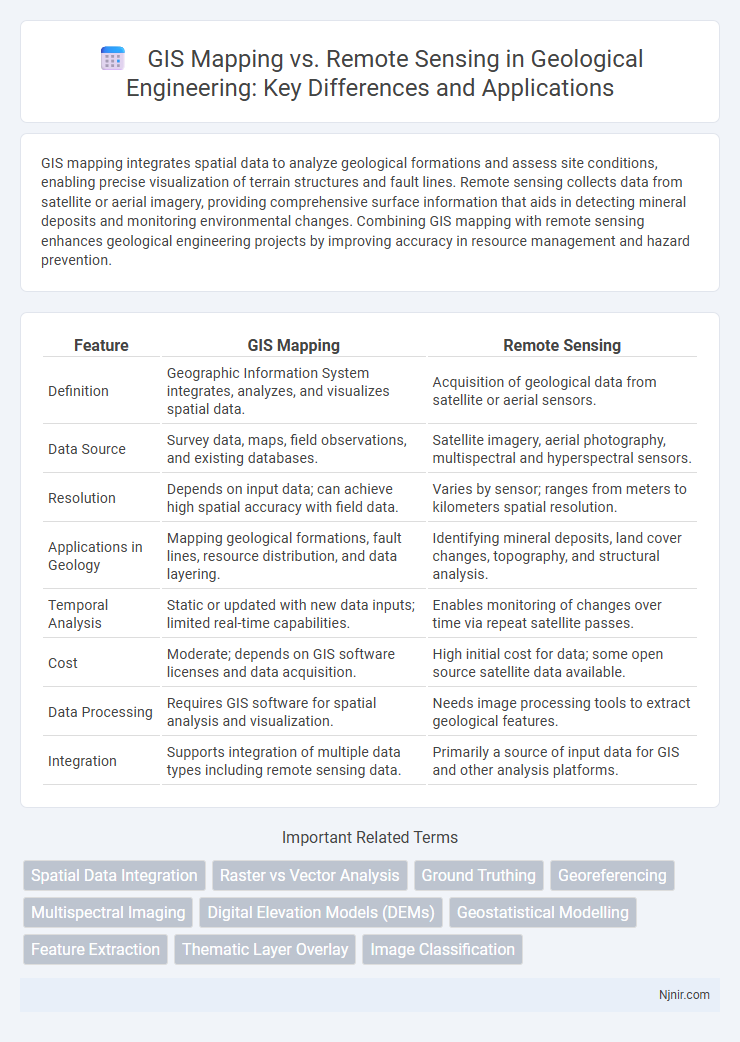
Table of Comparison
| Feature | GIS Mapping | Remote Sensing |
|---|---|---|
| Definition | Geographic Information System integrates, analyzes, and visualizes spatial data. | Acquisition of geological data from satellite or aerial sensors. |
| Data Source | Survey data, maps, field observations, and existing databases. | Satellite imagery, aerial photography, multispectral and hyperspectral sensors. |
| Resolution | Depends on input data; can achieve high spatial accuracy with field data. | Varies by sensor; ranges from meters to kilometers spatial resolution. |
| Applications in Geology | Mapping geological formations, fault lines, resource distribution, and data layering. | Identifying mineral deposits, land cover changes, topography, and structural analysis. |
| Temporal Analysis | Static or updated with new data inputs; limited real-time capabilities. | Enables monitoring of changes over time via repeat satellite passes. |
| Cost | Moderate; depends on GIS software licenses and data acquisition. | High initial cost for data; some open source satellite data available. |
| Data Processing | Requires GIS software for spatial analysis and visualization. | Needs image processing tools to extract geological features. |
| Integration | Supports integration of multiple data types including remote sensing data. | Primarily a source of input data for GIS and other analysis platforms. |
Introduction to GIS Mapping and Remote Sensing
GIS mapping integrates spatial data to create detailed, interactive maps that support analysis and decision-making across various fields like urban planning and environmental management. Remote sensing employs satellite or aerial imagery to capture real-time data about the Earth's surface, enabling monitoring of land use, vegetation health, and natural disasters. Both technologies complement each other, with GIS providing a framework for organizing remote sensing data to enhance spatial analysis and visualization.
Key Differences Between GIS Mapping and Remote Sensing
GIS mapping and remote sensing serve distinct functions in geospatial analysis; GIS mapping focuses on capturing, storing, analyzing, and visualizing spatial data through layered information systems, while remote sensing involves acquiring data about the Earth's surface using satellite or aerial sensors. GIS integrates various data sources to create detailed maps and perform spatial analysis, whereas remote sensing provides raw imagery and spectral data that need further processing for interpretation. The key difference lies in GIS's role as a data management and analysis tool versus remote sensing's function as a data acquisition technique.
Core Principles of GIS Mapping in Geological Engineering
GIS mapping in geological engineering centers on spatial data integration, enabling the visualization and analysis of geological formations, fault lines, and mineral deposits with high precision. Core principles include data layering, spatial analysis, and attribute linkage, which facilitate accurate mapping of subsurface structures and resource distribution. This approach supports decision-making in exploration and hazard assessment by combining geographic coordinates with geological attributes for comprehensive modeling.
Remote Sensing Technologies in Geological Applications
Remote sensing technologies play a crucial role in geological applications by providing high-resolution satellite imagery and airborne sensor data for detailed surface and subsurface analysis. Techniques such as LiDAR, multispectral, and hyperspectral imaging enable the identification of mineral compositions, fault lines, and landform changes with precision that enhances exploration and hazard assessment. Integration of data from remote sensing complements traditional GIS mapping, improving the accuracy and scope of geological modeling and resource management.
Data Acquisition: GIS Mapping vs Remote Sensing
GIS mapping relies on data acquisition from various sources including satellite imagery, aerial photographs, GPS, and field surveys, enabling integration and analysis of spatial information within a geographic framework. Remote sensing, on the other hand, specifically involves acquiring data from sensors mounted on satellites or aircraft that detect and record reflected or emitted electromagnetic radiation. While GIS mapping synthesizes diverse spatial datasets for visualization and decision-making, remote sensing primarily focuses on capturing raw environmental data over large areas for further processing.
Spatial Analysis Techniques in Geological Engineering
Spatial analysis techniques in geological engineering leverage GIS mapping to integrate, visualize, and analyze geospatial data for terrain modeling, mineral exploration, and hazard assessment. Remote sensing complements these efforts by providing high-resolution, multispectral imagery and elevation data critical for identifying geological features, monitoring landform changes, and assessing surface materials. Combining GIS mapping's spatial data management with remote sensing's real-time environmental observations enhances the accuracy and efficiency of subsurface investigations and geohazard predictions.
Integration of GIS and Remote Sensing for Geological Studies
Integration of GIS mapping and remote sensing enhances geological studies by combining spatial analysis capabilities with detailed surface data acquisition. Remote sensing provides high-resolution satellite imagery and multispectral data crucial for identifying lithological units, fault lines, and mineral deposits, while GIS facilitates the overlay, visualization, and spatial modeling of this information for comprehensive geospatial analysis. The synergy between GIS and remote sensing accelerates resource exploration, hazard assessment, and environmental monitoring through precise data integration and interpretation.
Advantages and Limitations of GIS Mapping
GIS mapping excels in integrating diverse spatial data layers, enabling detailed analysis and visualization of geographical patterns crucial for urban planning, environmental management, and disaster response. Its limitations include dependency on accurate and up-to-date data, high costs of software and training, and challenges in handling real-time data updates compared to remote sensing. While GIS provides powerful tools for decision-making through data manipulation and spatial querying, it relies heavily on the quality and availability of input data, which can affect the accuracy and reliability of its outputs.
Benefits and Constraints of Remote Sensing Methods
Remote sensing methods offer significant benefits in GIS mapping by providing extensive spatial data acquisition over large and inaccessible areas, enabling real-time monitoring and multi-spectral analysis for detailed environmental assessments. Constraints of remote sensing include limitations due to atmospheric conditions, sensor resolution, and the need for specialized expertise to interpret complex data accurately. Despite these challenges, remote sensing remains a critical tool for enhancing GIS applications, particularly in land use planning, disaster management, and resource monitoring.
Future Trends in GIS Mapping and Remote Sensing for Geology
Future trends in GIS mapping and remote sensing for geology emphasize the integration of high-resolution satellite imagery with real-time data analytics to improve mineral exploration and environmental monitoring. Advances in machine learning algorithms enhance the precision of geological hazard prediction and subsurface mapping by analyzing multi-spectral and LiDAR data. The convergence of UAV (drone) technologies with cloud-based GIS platforms enables dynamic, large-scale geological surveys, promoting more accurate and timely decision-making in resource management and disaster mitigation.
Spatial Data Integration
Spatial data integration in GIS mapping combines diverse geospatial datasets to create comprehensive, multi-layered maps, while remote sensing provides real-time, high-resolution imagery essential for accurate spatial analysis.
Raster vs Vector Analysis
Raster analysis in remote sensing excels at processing continuous spatial data through pixel-based images, while vector analysis in GIS mapping efficiently handles discrete spatial features using points, lines, and polygons for precise spatial relationships.
Ground Truthing
Ground truthing validates GIS mapping and remote sensing data by providing accurate on-site measurements that improve spatial analysis accuracy and environmental monitoring.
Georeferencing
Georeferencing in GIS mapping involves aligning spatial data with geographic coordinates, while in remote sensing it entails assigning real-world coordinates to satellite or aerial imagery for accurate spatial analysis.
Multispectral Imaging
Multispectral imaging in remote sensing captures data across multiple wavelengths to analyze Earth's surface, while GIS mapping integrates this data for spatial analysis and visualization.
Digital Elevation Models (DEMs)
Digital Elevation Models (DEMs) generated through remote sensing provide high-resolution terrain data, while GIS mapping integrates these DEMs with spatial analysis tools for enhanced topographic visualization and decision-making.
Geostatistical Modelling
Geostatistical modeling in GIS mapping enables precise spatial data analysis by integrating location-based datasets, whereas remote sensing provides continuous surface data inputs crucial for enhancing the accuracy of these predictive models.
Feature Extraction
GIS mapping enables precise spatial analysis and organization of geographic features, while remote sensing excels in automated feature extraction by capturing multispectral data for identifying and classifying land cover changes.
Thematic Layer Overlay
Thematic Layer Overlay in GIS mapping integrates multiple spatial data layers for comprehensive analysis, while remote sensing provides the essential raw imagery used to create and update these thematic layers accurately.
Image Classification
Remote sensing provides raw satellite or aerial imagery crucial for image classification, while GIS mapping organizes and analyzes classified data to produce detailed spatial representations.
GIS mapping vs remote sensing Infographic