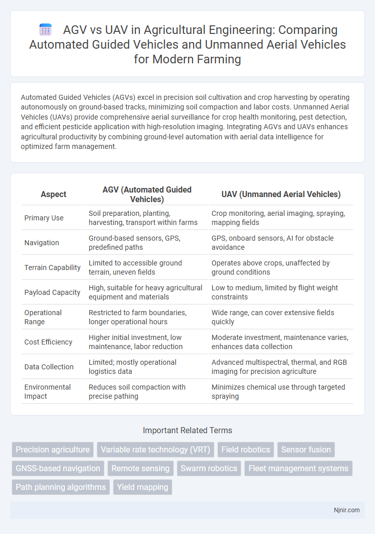
Automated Guided Vehicles (AGVs) excel in precision soil cultivation and crop harvesting by operating autonomously on ground-based tracks, minimizing soil compaction and labor costs. Unmanned Aerial Vehicles (UAVs) provide comprehensive aerial surveillance for crop health monitoring, pest detection, and efficient pesticide application with high-resolution imaging. Integrating AGVs and UAVs enhances agricultural productivity by combining ground-level automation with aerial data intelligence for optimized farm management.
Table of Comparison
| Aspect | AGV (Automated Guided Vehicles) | UAV (Unmanned Aerial Vehicles) |
|---|---|---|
| Primary Use | Soil preparation, planting, harvesting, transport within farms | Crop monitoring, aerial imaging, spraying, mapping fields |
| Navigation | Ground-based sensors, GPS, predefined paths | GPS, onboard sensors, AI for obstacle avoidance |
| Terrain Capability | Limited to accessible ground terrain, uneven fields | Operates above crops, unaffected by ground conditions |
| Payload Capacity | High, suitable for heavy agricultural equipment and materials | Low to medium, limited by flight weight constraints |
| Operational Range | Restricted to farm boundaries, longer operational hours | Wide range, can cover extensive fields quickly |
| Cost Efficiency | Higher initial investment, low maintenance, labor reduction | Moderate investment, maintenance varies, enhances data collection |
| Data Collection | Limited; mostly operational logistics data | Advanced multispectral, thermal, and RGB imaging for precision agriculture |
| Environmental Impact | Reduces soil compaction with precise pathing | Minimizes chemical use through targeted spraying |
Introduction to AGVs and UAVs in Agricultural Engineering
Automated Guided Vehicles (AGVs) in agricultural engineering are ground-based machines designed to autonomously transport materials, perform field tasks such as planting, harvesting, and soil analysis, improving efficiency and precision in farm operations. Unmanned Aerial Vehicles (UAVs), or drones, provide aerial surveillance and data collection, facilitating crop monitoring, pest detection, and irrigation management through high-resolution imaging and real-time analytics. Both AGVs and UAVs integrate advanced sensors, GPS technology, and machine learning algorithms to optimize agricultural productivity and reduce labor costs.
Core Technologies: AGVs vs UAVs
AGVs rely heavily on laser scanners, magnetic tapes, and embedded sensors for precise indoor navigation and obstacle detection, ensuring smooth operation in controlled environments such as warehouses and factories. UAVs utilize advanced GPS modules, IMUs (Inertial Measurement Units), high-resolution cameras, and real-time data processing for autonomous flight, dynamic route planning, and environmental awareness in complex, outdoor airspaces. Both systems incorporate AI-driven algorithms and machine learning to enhance path optimization, object recognition, and safety protocols, tailored to their respective operational domains.
Applications of AGVs in Precision Farming
Automated Guided Vehicles (AGVs) excel in precision farming by enabling autonomous soil sampling, targeted pesticide application, and efficient crop harvesting with minimal human intervention. AGVs navigate farm fields using GPS and sensor technologies to perform tasks that enhance crop yield and reduce resource waste. Unlike Unmanned Aerial Vehicles (UAVs), which primarily provide aerial imagery and monitoring, AGVs physically interact with crops, optimizing on-ground agricultural operations.
UAV Applications in Crop Monitoring and Management
UAVs (Unmanned Aerial Vehicles) offer advanced capabilities in crop monitoring through high-resolution multispectral and thermal imaging, enabling precise assessment of crop health, soil conditions, and pest infestations. Unlike AGVs (Automated Guided Vehicles) that operate primarily on the ground, UAVs provide comprehensive aerial surveillance, facilitating efficient management of large agricultural fields and timely decision-making. This aerial data collection supports optimized irrigation, targeted pesticide application, and yield prediction, significantly enhancing sustainable farming practices.
Efficiency Comparison: Field Coverage and Productivity
AGVs excel in efficiency for indoor and controlled environment tasks, offering consistent field coverage with precise navigation and high payload capacity, which boosts productivity in manufacturing and warehousing. UAVs provide superior field coverage in expansive or hard-to-reach outdoor areas, enabling rapid data collection and real-time monitoring that enhances productivity in agriculture, surveying, and inspection. While AGVs optimize repetitive ground operations with minimal downtime, UAVs maximize spatial efficiency through aerial mobility and speed, making their productivity context-dependent on operational environments.
Cost Analysis: Investment and Operational Expenses
Automated Guided Vehicles (AGVs) typically require significant initial investment in infrastructure like floor sensors and guidance systems, resulting in higher upfront costs compared to Unmanned Aerial Vehicles (UAVs), which demand advanced avionics but offer more flexible deployment. Operational expenses for AGVs include maintenance of physical pathways and regular software updates, while UAVs incur costs related to battery replacement, compliance with aviation regulations, and skilled personnel for operation. Cost analysis reveals AGVs are more cost-effective for fixed, repetitive tasks in controlled environments, whereas UAVs provide scalable solutions with potentially lower ongoing expenses in dynamic or outdoor applications.
Data Collection Capabilities: Ground vs Aerial Perspectives
Automated Guided Vehicles (AGVs) excel in precise, ground-level data collection, providing detailed scans of floor surfaces, inventory positioning, and localized environmental monitoring. Unmanned Aerial Vehicles (UAVs) capture expansive aerial perspectives, enabling rapid surveys of large areas, topographical mapping, and real-time 3D imaging from various altitudes. Combining AGV ground-level accuracy with UAV aerial scope optimizes comprehensive data acquisition for industries like logistics, agriculture, and infrastructure inspection.
Integration Potential with Other Smart Farming Systems
AGVs (Automated Guided Vehicles) seamlessly integrate with ground-based smart farming systems such as soil sensors, irrigation controls, and crop monitoring platforms, enabling precise field navigation and targeted resource application. UAVs (Unmanned Aerial Vehicles) complement this by providing aerial imaging for real-time crop health analysis and terrain mapping, feeding critical data into farm management software. The combined integration of AGVs and UAVs enhances precision agriculture by synchronizing ground operations with aerial surveillance, optimizing crop yield and resource efficiency.
Challenges and Limitations of AGVs and UAVs
AGVs (Automated Guided Vehicles) face challenges such as limited maneuverability in complex environments, dependency on predefined paths, and vulnerability to obstacles or floor conditions that disrupt navigation. UAVs (Unmanned Aerial Vehicles) encounter limitations including restricted flight time due to battery capacity, regulatory constraints for airspace usage, and susceptibility to adverse weather conditions that affect stability and safety. Both technologies demand continuous advancements in sensor accuracy, autonomous decision-making, and operational reliability to overcome these inherent challenges.
Future Trends: The Evolving Role of AGVs and UAVs in Agriculture
AGVs and UAVs are transforming agriculture through precision farming and autonomous operations, with AGVs enhancing soil management and crop harvesting while UAVs excel in aerial monitoring and crop health analysis. The integration of AI and IoT technologies drives the evolution of these vehicles, enabling real-time data collection and adaptive decision-making to optimize yields and resource use. Emerging trends indicate an increased synergy between AGVs and UAVs, fostering smart farms with automated ground and aerial systems working collaboratively for sustainable agriculture.
Precision agriculture
Automated Guided Vehicles (AGVs) enhance crop harvesting accuracy through ground-level precision, while Unmanned Aerial Vehicles (UAVs) provide high-resolution aerial imaging for optimized crop monitoring in precision agriculture.
Variable rate technology (VRT)
Automated Guided Vehicles (AGVs) and Unmanned Aerial Vehicles (UAVs) both utilize Variable Rate Technology (VRT) to optimize precision in agricultural applications, with AGVs providing ground-based targeted input delivery and UAVs enabling aerial, real-time crop monitoring and variable input application.
Field robotics
AGVs excel in ground-based, repetitive logistics tasks with stable navigation, while UAVs offer superior aerial mobility and flexibility for dynamic field robotics applications such as surveillance and environmental monitoring.
Sensor fusion
Sensor fusion in AGVs integrates lidar, ultrasonic, and infrared sensors for precise indoor navigation, while UAVs combine GPS, IMU, and optical sensors to enhance aerial positioning and obstacle avoidance.
GNSS-based navigation
GNSS-based navigation enhances UAV efficiency and coverage in diverse terrains while AGVs rely more on fixed-path guidance systems, limiting their operational flexibility.
Remote sensing
AGVs provide precise ground-level data acquisition with stable, GPS-referenced sensing ideal for controlled environments, while UAVs offer versatile, high-resolution aerial remote sensing capable of covering extensive, inaccessible terrains efficiently.
Swarm robotics
Swarm robotics leverages AGVs for coordinated ground logistics and UAVs for aerial surveillance, maximizing efficiency through autonomous, scalable multi-vehicle collaboration.
Fleet management systems
Fleet management systems for AGVs optimize ground-based logistics by integrating real-time navigation, collision avoidance, and task allocation, while UAV fleet management emphasizes dynamic air traffic control, route planning, and compliance with aviation regulations to enhance aerial operational efficiency.
Path planning algorithms
Path planning algorithms for AGVs optimize navigation on structured indoor surfaces using grid-based or graph search methods, while UAVs rely on dynamic 3D environment mapping and probabilistic algorithms to navigate complex airspaces.
Yield mapping
AGVs provide precise yield mapping through ground-level crop data collection with minimal disturbance, while UAVs enable rapid aerial yield mapping over large areas, offering high-resolution multispectral imaging for crop health analysis.
AGV (Automated Guided Vehicles) vs UAV (Unmanned Aerial Vehicles) Infographic