Remote sensing enables large-scale crop monitoring through satellite and drone imagery, offering timely data on plant health and soil conditions. Field scouting provides hands-on assessment, allowing precise identification of pests, diseases, and nutrient deficiencies on individual plants. Combining both methods enhances decision-making by integrating broad spatial data with detailed ground-level insights.
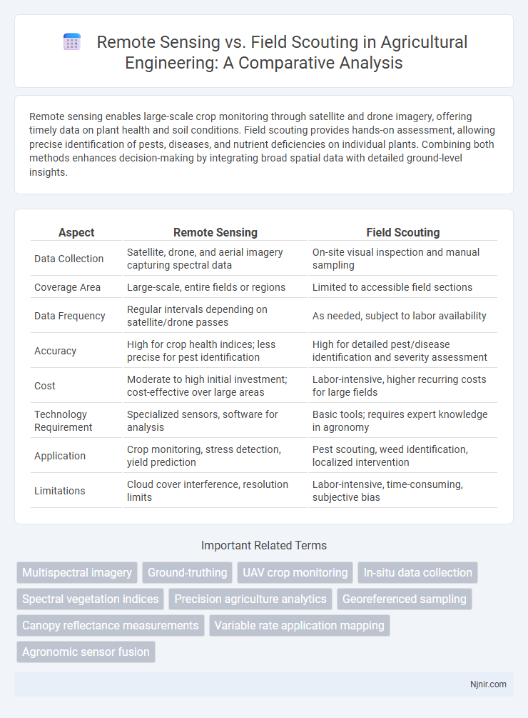
Table of Comparison
| Aspect | Remote Sensing | Field Scouting |
|---|---|---|
| Data Collection | Satellite, drone, and aerial imagery capturing spectral data | On-site visual inspection and manual sampling |
| Coverage Area | Large-scale, entire fields or regions | Limited to accessible field sections |
| Data Frequency | Regular intervals depending on satellite/drone passes | As needed, subject to labor availability |
| Accuracy | High for crop health indices; less precise for pest identification | High for detailed pest/disease identification and severity assessment |
| Cost | Moderate to high initial investment; cost-effective over large areas | Labor-intensive, higher recurring costs for large fields |
| Technology Requirement | Specialized sensors, software for analysis | Basic tools; requires expert knowledge in agronomy |
| Application | Crop monitoring, stress detection, yield prediction | Pest scouting, weed identification, localized intervention |
| Limitations | Cloud cover interference, resolution limits | Labor-intensive, time-consuming, subjective bias |
Overview of Remote Sensing and Field Scouting
Remote sensing utilizes satellite or drone imagery to collect extensive spatial data on crop health, soil conditions, and pest infestations, enabling precise monitoring over large agricultural areas. Field scouting involves on-the-ground inspections by agronomists or scouts to assess plant health, detect pests, and verify remote sensing data through direct observation and sampling. Combining remote sensing with field scouting improves accuracy in crop management decisions by integrating large-scale data analysis with detailed, site-specific insights.
Key Technologies in Remote Sensing for Agriculture
Remote sensing technologies in agriculture leverage satellite imagery, drones, and multispectral sensors to capture detailed crop health data, soil moisture levels, and pest infestations from large areas efficiently. Advanced data analytics and machine learning algorithms enhance the interpretation of spectral data, enabling precise monitoring of crop conditions and forecasting yields. Compared to traditional field scouting, remote sensing offers scalable, real-time insights that improve decision-making and resource management while reducing labor costs.
Traditional Field Scouting: Methods and Tools
Traditional field scouting involves manual inspection of crops using tools such as handheld GPS devices, soil probes, and visual observation to detect pests, diseases, and nutrient deficiencies. This method relies heavily on the expertise and experience of agronomists or farmers, requiring frequent and labor-intensive site visits. Despite its time-consuming nature, field scouting provides detailed, ground-level data critical for accurate diagnosis and immediate intervention.
Data Accuracy: Remote Sensing vs Field Scouting
Remote sensing offers high spatial and temporal data accuracy by capturing large-scale environmental variables through multispectral and hyperspectral sensors, enabling consistent monitoring over time. Field scouting provides ground-truth data with precise, real-time observations, capturing micro-level variability and plant conditions that remote sensors may miss. Combining remote sensing with field scouting optimizes data accuracy, enhancing precision agriculture decision-making by validating sensor data and filling gaps with on-the-ground insights.
Cost-Benefit Analysis of Monitoring Approaches
Remote sensing offers large-scale, cost-effective monitoring with rapid data collection, reducing labor and time expenses compared to traditional field scouting. Field scouting provides detailed, ground-truth data crucial for accurate diagnosis but incurs higher labor costs and limited spatial coverage. Combining both methods optimizes cost-benefit by leveraging remote sensing's broad surveillance and field scouting's precise validation, enhancing decision-making efficiency in agricultural management.
Spatial and Temporal Resolution Comparison
Remote sensing offers high spatial resolution through satellite and drone imagery, enabling coverage of large agricultural areas with pixel sizes ranging from sub-meter to several meters. Field scouting provides detailed, ground-level observations but is limited in spatial coverage and time-consuming to conduct extensively. Temporal resolution in remote sensing varies with satellite revisit times, often days to weeks, while field scouting allows for immediate and flexible on-site assessments, critical for timely crop management decisions.
Integration of Remote Sensing and Field Scouting
Integration of remote sensing and field scouting enhances agricultural monitoring by combining large-scale aerial data with precise ground observations. Remote sensing provides continuous, high-resolution imagery to detect crop health variations, while field scouting validates these observations and identifies local factors affecting growth. This synergistic approach improves decision-making accuracy and crop management efficiency by leveraging complementary strengths of both methods.
Impact on Crop Health Assessment
Remote sensing offers comprehensive crop health assessment by utilizing satellite or drone imagery to detect stress indicators such as chlorophyll levels and water deficiency across large agricultural areas efficiently. Field scouting provides precise, ground-truth information by enabling direct observation of crop conditions, pest presence, and disease symptoms, which helps validate and refine remote sensing data. Integrating remote sensing with field scouting enhances crop health monitoring accuracy and supports timely, data-driven management decisions.
Limitations and Challenges of Both Methods
Remote sensing faces limitations such as difficulty in capturing fine-scale variations and susceptibility to cloud cover, which can hinder accurate data acquisition. Field scouting challenges include time-intensive labor, limited spatial coverage, and human error in data collection. Both methods struggle with environmental factors and require integration for comprehensive crop monitoring and precision agriculture.
Future Trends in Agricultural Monitoring Techniques
Remote sensing technologies, including satellite imagery and drone-based sensors, offer expansive, real-time data for crop health and soil conditions, enabling precise monitoring at scale. Field scouting remains crucial for detailed, on-the-ground verification and detecting specific pest or disease issues that remote sensing may overlook. Future trends emphasize integrating AI-driven analytics with multi-spectral remote sensing and IoT-enabled field sensors, creating hybrid systems that maximize accuracy and efficiency in agricultural monitoring.
Multispectral imagery
Multispectral imagery in remote sensing enables precise, large-scale vegetation health monitoring and stress detection, outperforming conventional field scouting by providing real-time, comprehensive data across diverse wavelengths.
Ground-truthing
Ground-truthing in remote sensing validates satellite or aerial data through accurate, on-site field scouting measurements to ensure precise environmental and agricultural analysis.
UAV crop monitoring
UAV crop monitoring using remote sensing provides high-resolution, real-time data on crop health and stress, outperforming traditional field scouting in efficiency and spatial coverage.
In-situ data collection
In-situ data collection through field scouting provides high-accuracy, ground-truth information essential for validating remote sensing data in precision agriculture.
Spectral vegetation indices
Spectral vegetation indices derived from remote sensing enable large-scale, precise monitoring of plant health and stress, while field scouting provides detailed, on-the-ground validation and contextual insight.
Precision agriculture analytics
Remote sensing in precision agriculture analytics provides large-scale, high-resolution data on crop health and soil conditions, while field scouting offers detailed, ground-level observations essential for validating remote data and diagnosing specific issues.
Georeferenced sampling
Georeferenced sampling enhances remote sensing by providing precise, location-based field scouting data that improves accuracy in vegetation and soil monitoring.
Canopy reflectance measurements
Canopy reflectance measurements obtained through remote sensing provide large-scale, consistent spectral data that enhance crop monitoring accuracy compared to localized, labor-intensive field scouting methods.
Variable rate application mapping
Variable rate application mapping achieves higher precision by integrating remote sensing data with field scouting insights to optimize input usage and crop management.
Agronomic sensor fusion
Agronomic sensor fusion integrating remote sensing and field scouting enhances crop monitoring accuracy by combining satellite imagery, UAV data, and on-site sensor measurements for precise soil and plant health analysis.
Remote sensing vs Field scouting Infographic