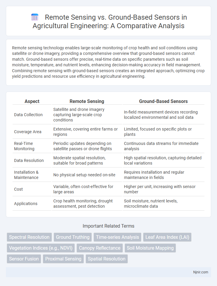
Remote sensing technology enables large-scale monitoring of crop health and soil conditions using satellite or drone imagery, providing a comprehensive overview that ground-based sensors cannot match. Ground-based sensors offer precise, real-time data on specific parameters such as soil moisture, temperature, and nutrient levels, enhancing decision-making accuracy in field management. Combining remote sensing with ground-based sensors creates an integrated approach, optimizing crop yield predictions and resource use efficiency in agricultural engineering.
Table of Comparison
| Aspect | Remote Sensing | Ground-Based Sensors |
|---|---|---|
| Data Collection | Satellite and drone imagery capturing large-scale crop conditions | In-field measurement devices recording localized environmental and soil data |
| Coverage Area | Extensive, covering entire farms or regions | Limited, focused on specific plots or plants |
| Real-Time Monitoring | Periodic updates depending on satellite passes or drone flights | Continuous data streams for immediate analysis |
| Data Resolution | Moderate spatial resolution, suitable for broad patterns | High spatial resolution, capturing detailed local variations |
| Installation & Maintenance | No physical setup needed on-site | Requires installation and regular maintenance in fields |
| Cost | Variable, often cost-effective for large areas | Higher per unit, increasing with sensor number |
| Applications | Crop health monitoring, drought assessment, pest detection | Soil moisture, nutrient levels, microclimate data |
Introduction to Remote Sensing and Ground-Based Sensors
Remote sensing involves acquiring data about an object or area from a distance, typically using satellite or aerial sensors, enabling large-scale environmental monitoring and spatial analysis. Ground-based sensors collect in-situ data directly from the environment, offering high-resolution, localized measurements essential for validating and complementing remote sensing data. Integrating remote sensing and ground-based sensor data enhances accuracy in applications such as climate studies, agriculture monitoring, and disaster management.
Core Principles of Remote Sensing in Agriculture
Remote sensing in agriculture relies on detecting and analyzing electromagnetic radiation reflected or emitted from crop fields using satellite or drone-based sensors, enabling large-scale monitoring of vegetation health, soil moisture, and crop growth stages. Ground-based sensors complement this approach by providing high-resolution, localized data such as soil nutrient levels, temperature, and plant stress indicators, essential for validating remote sensing data and improving accuracy. Core principles include understanding spectral signatures, sensor calibration, and spatial resolution to optimize crop management decisions and enhance precision agriculture outcomes.
Ground-Based Sensor Technologies Explained
Ground-based sensor technologies employ instruments such as LiDAR, multispectral, and hyperspectral sensors to capture high-resolution, localized environmental data directly from the Earth's surface. These sensors provide precise measurements of soil moisture, vegetation health, and atmospheric conditions, enabling detailed monitoring for agriculture, forestry, and climate research. Unlike remote sensing, ground-based sensors offer continuous, real-time data collection, enhancing accuracy and enabling immediate analysis in targeted areas.
Data Accuracy: Remote Sensing vs Ground-Based Sensors
Remote sensing technologies provide extensive spatial coverage but often face challenges in data accuracy due to atmospheric interference and sensor resolution limits. Ground-based sensors deliver higher precision and real-time measurements, offering detailed local environmental data critical for calibration and validation of remote sensing outputs. Combining both methods enhances overall data reliability, leveraging remote sensing's broad scope with ground-based sensors' accuracy.
Spatial and Temporal Resolution Comparison
Remote sensing technologies typically offer broad spatial coverage with resolutions varying from a few meters to several kilometers, allowing for large-scale environmental monitoring. Ground-based sensors provide higher spatial resolution at localized points, enabling detailed measurements but limited area coverage. Temporally, remote sensing platforms like satellites provide consistent revisit times ranging from hours to days, whereas ground-based sensors can continuously collect data in real-time, offering finer temporal granularity.
Cost-Benefit Analysis of Sensing Technologies
Remote sensing technologies offer extensive spatial coverage and rapid data collection at a lower operational cost compared to ground-based sensors, which require significant labor and maintenance expenses for localized monitoring. Ground-based sensors provide higher accuracy and real-time data critical for precise applications but involve substantial installation and calibration investments. A comprehensive cost-benefit analysis must weigh the scalability and broad-area insights of remote sensing against the detailed, site-specific precision and higher upfront costs of ground-based systems.
Integration of Remote and Ground-Based Data
Integration of remote sensing and ground-based sensors enhances environmental monitoring by combining large-scale spatial data with precise local measurements. This synergy improves the accuracy of land cover classification, climate modeling, and resource management through calibration and validation processes. Leveraging data fusion techniques enables comprehensive analysis, optimizing decision-making in agriculture, forestry, and urban planning.
Application Scenarios in Precision Agriculture
Remote sensing technologies, including satellite and drone imagery, enable large-scale monitoring of crop health, soil moisture, and nutrient levels across vast agricultural fields, facilitating timely and precise decision-making. Ground-based sensors provide high-resolution, real-time data on microclimate conditions, soil properties, and plant physiology, enhancing localized management practices such as irrigation scheduling and pest detection. Integrating remote sensing with ground-based sensors optimizes precision agriculture by combining macro-level spatial analysis with detailed site-specific insights, improving yield prediction and resource efficiency.
Challenges and Limitations of Each Approach
Remote sensing faces challenges such as atmospheric interference, limited spatial resolution, and difficulty in capturing subsurface information, which constrain the accuracy of data collection over large areas. Ground-based sensors, while offering high precision and real-time measurements, are limited by spatial coverage, high deployment costs, and vulnerability to environmental conditions like weather and terrain. Both approaches require calibration and data integration to overcome these limitations and enhance overall monitoring effectiveness.
Future Trends in Agricultural Sensing Technologies
Emerging agricultural sensing technologies emphasize integrating remote sensing with ground-based sensors to enhance precision farming accuracy and timeliness. Advances in hyperspectral imaging, IoT-connected soil probes, and AI-driven data analytics enable real-time monitoring of crop health, soil moisture, and nutrient levels. The convergence of UAVs, satellite platforms, and smart sensor networks facilitates scalable, data-rich solutions for sustainable agriculture and optimized resource management.
Spectral Resolution
Remote sensing typically offers higher spectral resolution with multispectral or hyperspectral sensors covering broad areas, while ground-based sensors provide more detailed spectral data but with limited spatial coverage.
Ground Truthing
Ground truthing validates remote sensing data by collecting accurate, on-site measurements with ground-based sensors to ensure precise environmental analysis and mapping.
Time-series Analysis
Time-series analysis in remote sensing provides extensive temporal coverage and large-scale monitoring, while ground-based sensors offer high-resolution, precise data for localized temporal changes.
Leaf Area Index (LAI)
Remote sensing provides large-scale, spatially continuous Leaf Area Index (LAI) measurements, while ground-based sensors offer high-accuracy, localized LAI data crucial for validating remote observations.
Vegetation Indices (e.g., NDVI)
Remote sensing techniques provide large-scale, continuous Vegetation Indices like NDVI with high temporal frequency, while ground-based sensors offer precise, localized measurements critical for validating and calibrating remote sensing data.
Canopy Reflectance
Canopy reflectance measured by remote sensing offers broader spatial coverage and temporal frequency compared to ground-based sensors, enabling more comprehensive monitoring of vegetation health and dynamics.
Soil Moisture Mapping
Remote sensing provides large-scale, continuous soil moisture mapping via satellite data, whereas ground-based sensors offer localized, high-accuracy measurements essential for validating and calibrating remote observations.
Sensor Fusion
Sensor fusion integrates remote sensing and ground-based sensor data to enhance accuracy, spatial resolution, and reliability in environmental monitoring and precision agriculture.
Proximal Sensing
Proximal sensing uses ground-based sensors positioned close to the target for highly accurate, high-resolution data collection crucial for precision agriculture and environmental monitoring.
Spatial Resolution
Remote sensing typically offers broader spatial coverage with moderate spatial resolution, while ground-based sensors provide higher spatial resolution for detailed, localized measurements.
remote sensing vs ground-based sensors Infographic