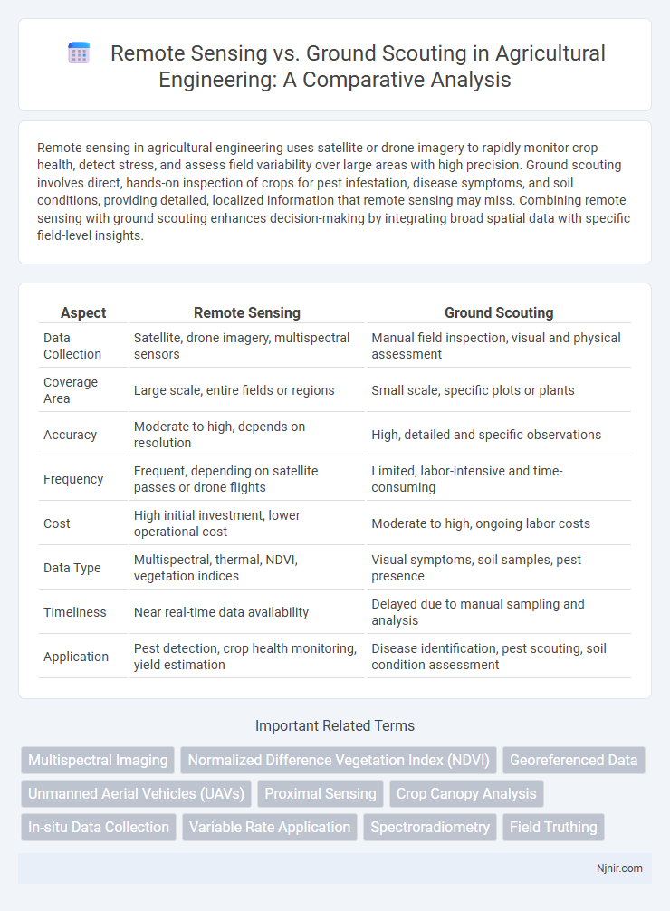
Remote sensing in agricultural engineering uses satellite or drone imagery to rapidly monitor crop health, detect stress, and assess field variability over large areas with high precision. Ground scouting involves direct, hands-on inspection of crops for pest infestation, disease symptoms, and soil conditions, providing detailed, localized information that remote sensing may miss. Combining remote sensing with ground scouting enhances decision-making by integrating broad spatial data with specific field-level insights.
Table of Comparison
| Aspect | Remote Sensing | Ground Scouting |
|---|---|---|
| Data Collection | Satellite, drone imagery, multispectral sensors | Manual field inspection, visual and physical assessment |
| Coverage Area | Large scale, entire fields or regions | Small scale, specific plots or plants |
| Accuracy | Moderate to high, depends on resolution | High, detailed and specific observations |
| Frequency | Frequent, depending on satellite passes or drone flights | Limited, labor-intensive and time-consuming |
| Cost | High initial investment, lower operational cost | Moderate to high, ongoing labor costs |
| Data Type | Multispectral, thermal, NDVI, vegetation indices | Visual symptoms, soil samples, pest presence |
| Timeliness | Near real-time data availability | Delayed due to manual sampling and analysis |
| Application | Pest detection, crop health monitoring, yield estimation | Disease identification, pest scouting, soil condition assessment |
Introduction to Remote Sensing and Ground Scouting
Remote sensing employs satellite or aerial sensor technologies to collect data about the Earth's surface, enabling large-scale observation and analysis of crops and environmental conditions without physical contact. Ground scouting involves direct, on-site inspection by agronomists or farmers to assess plant health, pest presence, and soil conditions through visual observation and sampling. While remote sensing provides extensive spatial coverage and real-time monitoring, ground scouting offers precise, detailed insights essential for accurate diagnosis and targeted management.
Key Technologies in Remote Sensing
Remote sensing leverages key technologies such as multispectral and hyperspectral imaging, LiDAR, and synthetic aperture radar (SAR) to capture detailed data from aerial or satellite platforms, enabling large-scale, real-time monitoring of crop health, soil conditions, and pest activity. Ground scouting relies on manual observation and sampling techniques, providing precise, localized information but limited by labor intensity and spatial coverage. Integrating remote sensing technologies with ground scouting enhances precision agriculture by combining wide-area detection with ground-truth validation.
Essential Tools for Effective Ground Scouting
Essential tools for effective ground scouting include handheld GPS devices, smartphones with agriculture apps, soil moisture sensors, and portable weather stations, enabling accurate data collection and real-time field monitoring. Remote sensing complements ground scouting by providing aerial imagery and multispectral data from satellites or drones, but ground-based observations offer detailed, site-specific insights crucial for diagnosing pest infestations and crop health. Integrating these tools enhances decision-making accuracy and optimizes crop management practices.
Data Accuracy: Remote Sensing vs Ground Scouting
Remote sensing provides extensive spatial coverage with consistent data collection through satellite or drone imagery, ensuring high-resolution insights over large agricultural areas. Ground scouting delivers highly accurate, localized data through direct observation and sampling, capturing detailed pest, disease, and crop health conditions that remote sensing might miss. Combining remote sensing with ground scouting enhances data accuracy by integrating broad-scale monitoring with precise field-level validation.
Cost and Resource Efficiency Comparison
Remote sensing significantly reduces labor costs and time by enabling large-area data collection through satellites and drones, whereas ground scouting demands substantial human resources and extended fieldwork hours. Resource efficiency of remote sensing is enhanced by automated data processing and real-time monitoring capabilities, in contrast to the manual data gathering and slower analysis inherent in ground scouting. Cost savings from remote sensing also stem from minimized travel expenses and the ability to cover inaccessible areas without physical presence, making it more scalable for extensive agricultural or environmental monitoring.
Scalability for Large-Scale Farm Operations
Remote sensing offers unparalleled scalability for large-scale farm operations by enabling rapid data collection over extensive areas using satellites, drones, or aerial imagery, which significantly reduces labor and time compared to ground scouting. Ground scouting, while providing highly detailed and localized insights through manual inspection, becomes labor-intensive and less feasible as farm size increases. Integrating remote sensing with selective ground scouting optimizes resource allocation and enhances decision-making in expansive agricultural landscapes.
Real-Time Monitoring Capabilities
Remote sensing offers real-time monitoring capabilities through satellite and drone imagery, enabling large-scale detection of crop health and environmental changes with high temporal frequency. Ground scouting provides immediate, in-field observations but lacks the continuous data flow and wide coverage that remote sensing delivers. Integrating remote sensing with ground scouting enhances real-time decision-making by combining extensive aerial data with precise, localized insights.
Integration with Precision Agriculture Systems
Remote sensing technology, utilizing satellite imagery and UAV data, offers large-scale, timely monitoring of crop health, enabling precise variability mapping in agricultural fields. Ground scouting provides detailed, in-field observations critical for validating remote data and detecting subtle pest or disease symptoms that sensors may miss. Integrating remote sensing with ground scouting enhances precision agriculture systems by combining macro-level spatial data with micro-level insights, optimizing decision-making for targeted interventions and resource management.
Limitations and Challenges of Each Approach
Remote sensing faces limitations such as lower spatial resolution, cloud cover interference, and difficulty in detecting small-scale or under-canopy issues, which restrict real-time and precise field condition assessment. Ground scouting provides detailed and accurate observations but is time-consuming, labor-intensive, and subject to human error and limited coverage area. Both methods challenge efficient crop monitoring individually, necessitating integrated approaches to optimize agricultural management.
Future Trends in Agricultural Monitoring
Remote sensing technologies in agricultural monitoring are rapidly advancing with enhanced satellite imaging, drone-based sensors, and AI-driven data analysis, enabling real-time crop health assessment and precision farming. Ground scouting remains vital for validating remote data and detecting early-stage pest infestations through direct observation and manual sampling. The future trend emphasizes integrating multi-source data streams to improve predictive analytics and optimize resource management in sustainable agriculture.
Multispectral Imaging
Multispectral imaging in remote sensing offers precise, large-scale vegetation health monitoring, surpassing ground scouting's limited spatial coverage and manual data collection.
Normalized Difference Vegetation Index (NDVI)
Remote sensing using Normalized Difference Vegetation Index (NDVI) provides large-scale, real-time vegetation health monitoring, while ground scouting offers detailed, site-specific observations for crop condition assessment.
Georeferenced Data
Georeferenced data in remote sensing provides extensive, spatially accurate environmental monitoring, while ground scouting offers precise, localized observations essential for validation and detailed crop assessment.
Unmanned Aerial Vehicles (UAVs)
Unmanned Aerial Vehicles (UAVs) in remote sensing provide high-resolution, real-time crop monitoring and data collection over large areas, surpassing the point-specific, labor-intensive nature of traditional ground scouting.
Proximal Sensing
Proximal sensing offers higher-resolution data and real-time monitoring capabilities compared to traditional remote sensing and ground scouting methods in agricultural field analysis.
Crop Canopy Analysis
Remote sensing provides large-scale, real-time crop canopy analysis through aerial imagery and multispectral data, while ground scouting offers detailed, site-specific observations for precise crop health assessment.
In-situ Data Collection
Remote sensing offers broad spatial coverage for environmental monitoring, whereas ground scouting provides precise in-situ data collection essential for validating remote observations and enhancing decision accuracy.
Variable Rate Application
Remote sensing enables precise Variable Rate Application by providing high-resolution, timely data on crop variability, whereas ground scouting offers localized insights but is less efficient for large-scale, real-time adjustments.
Spectroradiometry
Spectroradiometry in remote sensing provides precise, large-scale reflectance data for vegetation analysis, while ground scouting offers localized, detailed spectral measurements essential for validating and calibrating remote sensing results.
Field Truthing
Field truthing in remote sensing involves validating satellite or aerial data with precise ground scouting observations to ensure accurate environmental and agricultural assessments.
Remote sensing vs Ground scouting Infographic