UAV drones provide high-resolution, real-time data for precise crop monitoring and management, enabling targeted interventions that enhance yield and reduce resource waste. Satellite imagery offers broad area coverage and consistent temporal data but often lacks the spatial resolution and immediacy required for detailed field-level analysis. Integrating UAV data with satellite imagery optimizes agricultural decision-making by combining detailed local insights with comprehensive regional trends.
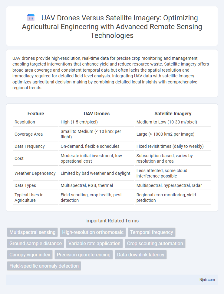
Table of Comparison
| Feature | UAV Drones | Satellite Imagery |
|---|---|---|
| Resolution | High (1-5 cm/pixel) | Medium to Low (10-30 m/pixel) |
| Coverage Area | Small to Medium (< 10 km2 per flight) | Large (> 1000 km2 per image) |
| Data Frequency | On-demand, flexible schedules | Fixed revisit times (daily to weekly) |
| Cost | Moderate initial investment, low operational cost | Subscription-based, varies by resolution and area |
| Weather Dependency | Limited by bad weather and daylight | Less affected, some cloud interference possible |
| Data Types | Multispectral, RGB, thermal | Multispectral, hyperspectral, radar |
| Typical Uses in Agriculture | Field scouting, crop health, pest detection | Regional crop monitoring, yield prediction |
Overview of UAV Drones and Satellite Imagery in Agriculture
UAV drones provide high-resolution, real-time aerial data crucial for precision agriculture, enabling detailed crop monitoring, pest detection, and targeted interventions. Satellite imagery offers broad-area coverage ideal for landscape-level analysis, crop health assessment, and long-term environmental monitoring but with lower spatial and temporal resolution compared to UAVs. Combining UAV drones with satellite imagery enhances agricultural decision-making by integrating fine-scale data with extensive geographic insights.
Data Acquisition Speed: UAVs vs Satellite Systems
UAV drones provide rapid data acquisition with real-time or near-real-time imaging capabilities, enabling immediate response for time-sensitive applications such as disaster monitoring and precision agriculture. Satellite systems, while covering vast areas, typically operate on fixed revisit schedules that can range from hours to days, limiting their data refresh rate. The faster deployment and flexible flight paths of UAVs deliver higher temporal resolution compared to satellites, making UAVs preferable for scenarios demanding quick and frequent data updates.
Spatial Resolution Comparison: Drones vs Satellites
UAV drones offer spatial resolutions as high as 1 to 5 centimeters per pixel, enabling detailed close-range imaging ideal for precision agriculture, construction, and environmental monitoring. Satellite imagery spatial resolution varies widely, with high-resolution commercial satellites providing 30 centimeters to 1 meter per pixel, while most satellites deliver between 10 to 30 meters per pixel, sufficient for broad-scale land cover and urban planning analyses. The significantly finer spatial resolution of UAV drones allows for more granular data capture, but satellites provide extensive geographic coverage and frequent revisit rates essential for large-area monitoring.
Temporal Flexibility for Monitoring Crops
UAV drones offer superior temporal flexibility for crop monitoring by enabling frequent, on-demand data collection tailored to specific growth stages and immediate analysis requirements. Satellite imagery, while providing broad area coverage, is limited by fixed orbital schedules and weather-dependent availability, resulting in less frequent imaging opportunities. The ability of UAVs to capture high-resolution data multiple times per growing season allows for timely detection of stress, pests, and water needs, optimizing precision agriculture practices.
Cost Analysis: UAV Drones vs Satellite Imagery
UAV drones offer significantly lower operational and deployment costs compared to satellite imagery, with expenses primarily related to equipment purchase and maintenance ranging from $1,000 to $25,000 per drone. Satellite imagery involves high costs for data acquisition, often reaching thousands of dollars per single high-resolution image, alongside recurring subscription fees for updated data access. The cost-effectiveness of UAV drones is pronounced for localized and frequent monitoring, whereas satellite imagery is more suitable for extensive coverage despite its higher financial burden.
Coverage Area: Field-Level vs Regional Assessment
UAV drones provide high-resolution, field-level coverage ideal for precision agriculture and localized monitoring, capturing detailed images of specific plots. Satellite imagery covers vast regional areas, enabling broad-scale environmental assessment and landscape analysis, albeit with lower spatial resolution. The choice depends on the required scale, with drones excelling in detailed, small-area data collection and satellites offering comprehensive regional overview.
Weather and Atmospheric Limitations
UAV drones provide high-resolution, real-time data but are constrained by adverse weather conditions such as heavy rain, strong winds, and fog that can impair flight stability and sensor accuracy. Satellite imagery, while less affected by localized weather, can suffer from cloud cover and atmospheric disturbances limiting visibility and temporal resolution. Both platforms require weather-adaptive technologies to ensure consistent data acquisition for environmental monitoring and mapping applications.
Data Integration with Precision Agriculture Tools
UAV drones capture high-resolution, real-time data that complements satellite imagery's broad coverage in precision agriculture, enabling comprehensive field analysis. Integrating drone-acquired multispectral and thermal data with satellite-based NDVI and soil moisture maps enhances crop health monitoring and yield prediction accuracy. This synergy between UAV and satellite platforms optimizes variable rate application of inputs, improving resource efficiency and sustainable farming practices.
Ease of Use and Technical Requirements
UAV drones offer greater ease of use with their user-friendly controls, real-time data capture, and rapid deployment compared to satellite imagery, which requires complex scheduling and high-level expertise. Technical requirements for drones typically involve lightweight hardware, GPS systems, and basic software for flight and data processing, making them accessible for various industries. Satellite imagery demands advanced ground stations, extensive data processing capabilities, and is dependent on orbital mechanics, limiting flexibility and immediate data acquisition.
Future Trends in Agricultural Remote Sensing Technologies
Future trends in agricultural remote sensing technologies emphasize enhanced synergy between UAV drones and satellite imagery to improve crop monitoring precision. UAV drones provide high-resolution, real-time data for localized analysis, while satellite imagery offers broad-area coverage and temporal frequency essential for large-scale farming operations. Integration of AI-driven analytics and multispectral sensors in both platforms is set to advance predictive modeling, optimize resource management, and drive sustainable agriculture practices.
Multispectral sensing
UAV drones offer higher-resolution multispectral sensing with greater flexibility and lower cost compared to satellite imagery for precision agriculture and environmental monitoring.
High-resolution orthomosaic
UAV drones provide higher-resolution orthomosaic imagery with greater spatial detail and flexibility than satellite imagery, enabling precise mapping and analysis in localized areas.
Temporal frequency
UAV drones provide higher temporal frequency in data capture than satellite imagery, enabling more frequent and timely monitoring of dynamic environments.
Ground sample distance
UAV drones achieve superior Ground Sample Distance (GSD) with high-resolution imaging at lower altitudes, providing finer spatial detail than satellite imagery typically constrained by higher orbital altitudes.
Variable rate application
UAV drones enable precise variable rate application through real-time, high-resolution data capture, outperforming satellite imagery's lower spatial resolution and infrequent revisit times in optimizing agricultural inputs.
Crop scouting automation
UAV drones provide high-resolution, real-time crop scouting automation outperforming satellite imagery by delivering precise data for early pest detection, stress analysis, and yield optimization in agriculture.
Canopy vigor index
UAV drones provide higher-resolution data than satellite imagery for accurately calculating the canopy vigor index, enabling precise monitoring of vegetation health and stress.
Precision georeferencing
UAV drones offer higher precision georeferencing than satellite imagery by capturing high-resolution, low-altitude data with centimeter-level accuracy, making them ideal for detailed mapping and localized analysis.
Data downlink latency
UAV drones provide significantly lower data downlink latency compared to satellite imagery, enabling faster real-time data transmission for time-sensitive applications.
Field-specific anomaly detection
UAV drones provide high-resolution, real-time field-specific anomaly detection surpassing satellite imagery's broader, less frequent data captures.
UAV drones vs Satellite imagery Infographic