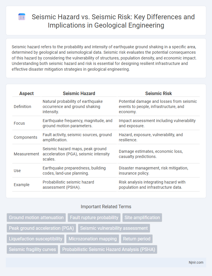
Seismic hazard refers to the probability and intensity of earthquake ground shaking in a specific area, determined by geological and seismological data. Seismic risk evaluates the potential consequences of this hazard by considering the vulnerability of structures, population density, and economic impact. Understanding both seismic hazard and risk is essential for designing resilient infrastructure and effective disaster mitigation strategies in geological engineering.
Table of Comparison
| Aspect | Seismic Hazard | Seismic Risk |
|---|---|---|
| Definition | Natural probability of earthquake occurrence and ground shaking intensity. | Potential damage and losses from seismic events to people, infrastructure, and economy. |
| Focus | Earthquake frequency, magnitude, and ground motion parameters. | Impact assessment including vulnerability and exposure. |
| Components | Fault activity, seismic sources, ground amplification. | Hazard, exposure, vulnerability, and resilience. |
| Measurement | Seismic hazard maps, peak ground acceleration (PGA), seismic intensity scales. | Damage estimates, economic loss, casualty predictions. |
| Use | Earthquake preparedness, building codes, land-use planning. | Disaster management, risk mitigation, insurance policy. |
| Example | Probabilistic seismic hazard assessment (PSHA). | Risk analysis integrating hazard with population and infrastructure data. |
Understanding Seismic Hazard: Definition and Importance
Seismic hazard refers to the probability and intensity of earthquake shaking at a specific location, determined by factors such as fault activity, earthquake magnitude, and ground conditions. Understanding seismic hazard is crucial for designing buildings and infrastructure to withstand potential earthquakes, minimizing structural damage and human casualties. Accurate seismic hazard assessment supports urban planning, emergency preparedness, and mitigation strategies to reduce overall seismic risk.
Seismic Risk Explained: Beyond the Hazard
Seismic risk encompasses the potential consequences of earthquake hazards by combining the likelihood of seismic events with the vulnerability of exposed structures and populations. Unlike seismic hazard, which measures the probability and intensity of ground shaking, seismic risk accounts for expected losses including economic damage, injuries, and disruptions. Effective risk assessment integrates hazard data with exposure and resilience factors to guide preparedness, mitigation, and emergency response strategies.
Key Differences Between Seismic Hazard and Seismic Risk
Seismic hazard refers to the natural phenomenon of earthquake occurrence, including the probability, intensity, and characteristics of ground shaking in a specific area. Seismic risk incorporates seismic hazard but also considers the vulnerability of population, infrastructure, and economic assets exposed to potential earthquakes. The key difference lies in seismic hazard being a measure of earthquake potential, whereas seismic risk quantifies the expected losses and impacts resulting from those hazards.
Methods of Seismic Hazard Assessment in Geological Engineering
Seismic hazard assessment in geological engineering involves evaluating the probability and intensity of earthquake ground shaking using probabilistic seismic hazard analysis (PSHA) and deterministic seismic hazard analysis (DSHA). PSHA incorporates seismic source characterization, ground motion prediction equations (GMPEs), and site response analysis to estimate the likelihood of various levels of seismic events over a specific time frame. These methods integrate geological, seismological, and geotechnical data to inform earthquake-resistant design and risk mitigation strategies.
Factors Influencing Seismic Risk in Infrastructure Projects
Seismic risk in infrastructure projects depends on multiple factors, including hazard intensity, vulnerability of construction materials, and the resilience of design standards. Site-specific geotechnical properties, such as soil type and fault proximity, significantly affect the severity of ground shaking and potential damage. Effective risk management integrates real-time seismic hazard data with adaptive engineering practices to minimize structural failure and ensure safety.
Role of Site Characterization in Seismic Studies
Seismic hazard quantifies the probability and intensity of earthquake shaking at a site, while seismic risk evaluates the potential damage and losses resulting from that shaking. Site characterization plays a crucial role in seismic studies by analyzing local soil conditions, geology, and ground motion amplification, directly influencing accurate hazard assessment. Detailed site data enhances seismic risk models, enabling more reliable predictions for infrastructure design and disaster preparedness.
Integrating Seismic Hazard and Risk Analysis in Design
Integrating seismic hazard and risk analysis in design involves combining the probabilistic assessment of earthquake ground motion (seismic hazard) with the evaluation of potential consequences to structures, infrastructure, and human lives (seismic risk). Advanced engineering practices utilize site-specific seismic hazard models alongside vulnerability and exposure data to develop resilient design criteria that minimize damage and ensure occupant safety. This integration supports performance-based design and risk-informed decision-making in earthquake-prone regions.
Mitigation Strategies for Reducing Seismic Risk
Seismic hazard refers to the probability and characteristics of earthquake ground shaking in a region, while seismic risk encompasses the potential damage and losses resulting from those hazards. Effective mitigation strategies for reducing seismic risk include implementing strict building codes that promote earthquake-resistant construction, retrofitting vulnerable infrastructure, and enhancing early warning systems to ensure timely evacuation. Community education and land-use planning also play critical roles in minimizing exposure and vulnerability to seismic events.
Advances in Seismic Hazard Modeling and Prediction
Recent advances in seismic hazard modeling leverage machine learning algorithms and high-resolution geospatial data to improve earthquake occurrence forecasts and ground shaking intensity predictions. Integration of real-time seismic monitoring with probabilistic hazard assessments enhances the accuracy of seismic hazard maps, enabling better-informed engineering and urban planning decisions. These innovations reduce uncertainties in hazard estimates and contribute significantly to mitigating seismic risk by informing resilience strategies and emergency preparedness.
Case Studies: Seismic Hazard and Risk Evaluation in Practice
Seismic hazard assessment quantifies the probability and intensity of earthquake shaking at a location, often using historical seismicity, fault data, and ground motion models. Seismic risk evaluation incorporates hazard data with exposure and vulnerability metrics to estimate potential losses to populations, infrastructure, and economic assets, enabling targeted mitigation strategies. Case studies from regions like California, Japan, and Nepal demonstrate how integrating detailed hazard mapping with socioeconomic data improves disaster preparedness and policy-making effectiveness.
Ground motion attenuation
Ground motion attenuation directly influences seismic hazard by reducing seismic energy with distance, which in turn affects seismic risk by determining the intensity and damage potential experienced at different locations.
Fault rupture probability
Seismic hazard quantifies the probability of fault rupture and ground shaking at a site, while seismic risk assesses the potential damage and losses resulting from these seismic events.
Site amplification
Site amplification significantly increases seismic risk by intensifying ground shaking beyond the baseline seismic hazard expected at a location.
Peak ground acceleration (PGA)
Seismic hazard quantifies the probability of peak ground acceleration (PGA) exceeding a specified level at a site, while seismic risk assesses the potential damage and losses resulting from that PGA during an earthquake.
Seismic vulnerability assessment
Seismic vulnerability assessment quantifies structural weaknesses to reduce seismic risk by understanding hazard exposure and potential damage.
Liquefaction susceptibility
Seismic hazard quantifies the probability of earthquake-induced ground shaking, while seismic risk assesses potential damage, with liquefaction susceptibility critically influencing soil stability and infrastructure vulnerability during seismic events.
Microzonation mapping
Seismic microzonation mapping differentiates seismic hazard--the probability and intensity of earthquake shaking--from seismic risk, which quantifies potential damage and losses in specific urban areas.
Return period
Seismic hazard quantifies the probability of earthquake ground motions exceeding a specific level within a given return period, while seismic risk assesses the potential damage and losses resulting from such events over the same return period.
Seismic fragility curves
Seismic fragility curves quantify the probability of structural damage at various earthquake intensities, linking seismic hazard data with risk assessments to predict potential losses.
Probabilistic Seismic Hazard Analysis (PSHA)
Probabilistic Seismic Hazard Analysis (PSHA) quantifies seismic hazard by estimating the likelihood of ground shaking intensity at a site, whereas seismic risk assesses potential damage and losses by combining hazard with vulnerability and exposure data.
seismic hazard vs seismic risk Infographic