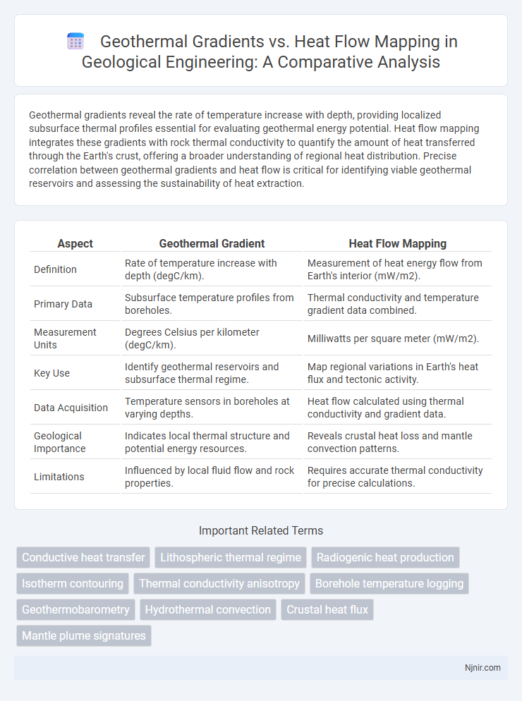
Geothermal gradients reveal the rate of temperature increase with depth, providing localized subsurface thermal profiles essential for evaluating geothermal energy potential. Heat flow mapping integrates these gradients with rock thermal conductivity to quantify the amount of heat transferred through the Earth's crust, offering a broader understanding of regional heat distribution. Precise correlation between geothermal gradients and heat flow is critical for identifying viable geothermal reservoirs and assessing the sustainability of heat extraction.
Table of Comparison
| Aspect | Geothermal Gradient | Heat Flow Mapping |
|---|---|---|
| Definition | Rate of temperature increase with depth (degC/km). | Measurement of heat energy flow from Earth's interior (mW/m2). |
| Primary Data | Subsurface temperature profiles from boreholes. | Thermal conductivity and temperature gradient data combined. |
| Measurement Units | Degrees Celsius per kilometer (degC/km). | Milliwatts per square meter (mW/m2). |
| Key Use | Identify geothermal reservoirs and subsurface thermal regime. | Map regional variations in Earth's heat flux and tectonic activity. |
| Data Acquisition | Temperature sensors in boreholes at varying depths. | Heat flow calculated using thermal conductivity and gradient data. |
| Geological Importance | Indicates local thermal structure and potential energy resources. | Reveals crustal heat loss and mantle convection patterns. |
| Limitations | Influenced by local fluid flow and rock properties. | Requires accurate thermal conductivity for precise calculations. |
Introduction to Geothermal Gradients and Heat Flow Mapping
Geothermal gradients measure the rate of temperature increase with depth in the Earth's crust, typically expressed in degC per kilometer, providing critical insights into subsurface thermal conditions. Heat flow mapping quantifies the Earth's heat transfer from its interior to the surface, caused by radioactive decay and residual heat, usually given in milliwatts per square meter (mW/m2). Together, geothermal gradients and heat flow data enable geothermal resource assessment, tectonic studies, and thermal modeling for energy exploration.
Fundamental Principles of Geothermal Gradients
Geothermal gradients measure the rate of temperature increase with depth in the Earth's subsurface, typically expressed in degrees Celsius per kilometer, reflecting the conductive heat transfer through rock layers. Heat flow mapping integrates geothermal gradient data with the thermal conductivity of rocks to quantify the amount of heat energy transferring from the Earth's interior to the surface, usually in milliwatts per square meter. Understanding geothermal gradients depends on accurate temperature measurements, rock thermal properties, and the balance between conductive and convective heat transfer mechanisms within geological formations.
Heat Flow Mapping: Techniques and Methodologies
Heat flow mapping involves measuring the rate of heat transfer from the Earth's interior to the surface, utilizing techniques such as borehole temperature measurements, thermal conductivity analysis of rock samples, and satellite remote sensing. These methodologies provide data critical for modeling subsurface temperature distributions and identifying geothermal resource potential. Accurate heat flow maps integrate geophysical surveys, geological data, and temperature gradients to enhance the understanding of geothermal systems and support energy exploration efforts.
Geological Factors Influencing Geothermal Gradients
Geological factors such as rock type, structural features, and tectonic settings significantly influence geothermal gradients, with conductive properties of rocks like granite or basalt affecting heat transfer rates. Heat flow mapping integrates these gradients with subsurface temperature data to identify variations in terrestrial heat distribution, highlighting areas with anomalously high heat flow caused by factors like magmatic intrusions or fault zones. Understanding the interplay between lithology, crustal thickness, and fluid circulation enables more accurate geothermal energy resource assessments and tectonic interpretations.
Tools and Instruments for Heat Flow Measurement
Heat flow measurement relies on tools such as thermal conductivity sensors, heat flux plates, and temperature probes installed in boreholes to capture precise geothermal gradients. These instruments provide critical data for heat flow mapping by measuring temperature differences and thermal conductivity within subsurface materials. Advanced heat flow mapping integrates these measurements with satellite thermal imaging and geophysical surveys to create detailed geothermal models for resource assessment.
Data Collection and Interpretation in Geothermal Surveys
Geothermal gradients measure the rate of temperature increase with depth, relying heavily on temperature data from boreholes to assess subsurface thermal conditions. Heat flow mapping requires the integration of thermal conductivity measurements with temperature gradients to calculate the amount of heat transferred per unit area. Accurate data collection involves precise temperature logging, thermal conductivity sampling, and spatial correlation, while interpretation utilizes these datasets to identify geothermal reservoirs and potential energy extraction sites.
Case Studies: Global Variations in Geothermal Gradients
Global variations in geothermal gradients reveal significant differences in Earth's subsurface temperatures, influenced by tectonic settings and crustal composition. Case studies from regions such as the Basin and Range Province in the USA, the East African Rift, and the Canadian Shield highlight how heat flow mapping complements gradient measurements by integrating surface heat flux data with borehole temperature profiles. These combined analyses improve the understanding of geothermal resource potential and enable precise regional geothermal energy exploration.
Applications of Heat Flow Mapping in Resource Exploration
Heat flow mapping crucially aids resource exploration by identifying subsurface thermal anomalies associated with hydrocarbon reservoirs, geothermal fields, and mineral deposits. It provides spatial variations in heat transfer, enabling more accurate predictions of rock properties, maturation levels, and fluid migration paths critical for oil and gas exploration. This method complements geothermal gradient data to optimize drilling locations, enhance reservoir characterization, and reduce exploration risks.
Challenges and Limitations in Geothermal and Heat Flow Analysis
Geothermal gradient and heat flow mapping face challenges due to heterogeneous subsurface properties and limited spatial data resolution, complicating accurate temperature distribution modeling. Variations in rock thermal conductivity and fluid movements introduce uncertainties in heat flow calculations, affecting the reliability of geothermal resource assessments. Measurement inaccuracies, surface temperature fluctuations, and sparse borehole data limit precise characterization of geothermal potential and require advanced correction techniques for robust analysis.
Future Trends in Geothermal Gradient and Heat Flow Research
Future trends in geothermal gradient and heat flow research emphasize enhanced subsurface imaging technologies, integrating high-resolution seismic data and machine learning algorithms to improve spatial accuracy of thermal models. Advances in remote sensing and continuous monitoring networks enable real-time heat flow mapping, facilitating adaptive geothermal resource management and exploration. Emerging interdisciplinary approaches combine geochemical analysis with thermal data to understand dynamic tectonic processes affecting heat distribution and gradient variations.
Conductive heat transfer
Geothermal gradients measure temperature increase with depth reflecting conductive heat transfer, while heat flow mapping quantifies the rate of conductive heat transfer through Earth's crust by combining geothermal gradient data with thermal conductivity values.
Lithospheric thermal regime
Geothermal gradients measure vertical temperature changes, while heat flow mapping quantifies heat transfer across the lithosphere, together defining the lithospheric thermal regime crucial for understanding tectonic and geothermal processes.
Radiogenic heat production
Radiogenic heat production significantly influences geothermal gradients and is a critical factor in accurate heat flow mapping for geothermal energy exploration.
Isotherm contouring
Isotherm contouring in heat flow mapping provides precise visualization of subsurface temperature distributions enhancing the interpretation of geothermal gradients for accurate geothermal resource assessment.
Thermal conductivity anisotropy
Thermal conductivity anisotropy significantly influences geothermal gradients and heat flow mapping by causing directional variations in heat transfer efficiency within subsurface rock formations.
Borehole temperature logging
Borehole temperature logging provides critical data for geothermal gradient measurement, enabling accurate heat flow mapping essential for geothermal energy exploration.
Geothermobarometry
Geothermobarometry utilizes mineral compositions to estimate pressure-temperature conditions, providing localized geothermal gradients that enhance the accuracy of regional heat flow mapping in geothermal studies.
Hydrothermal convection
Hydrothermal convection significantly influences geothermal gradients and heat flow mapping by redistributing heat through fluid movement, causing localized anomalies that challenge accurate subsurface temperature predictions.
Crustal heat flux
Crustal heat flux mapping quantifies geothermal gradients by integrating subsurface temperature data with thermal conductivity measurements to evaluate Earth's heat flow distribution.
Mantle plume signatures
Geothermal gradient and heat flow mapping reveal mantle plume signatures by detecting anomalously high temperatures and increased heat flow rates indicative of upwelling mantle material beneath Earth's crust.
Geothermal gradients vs Heat flow mapping Infographic