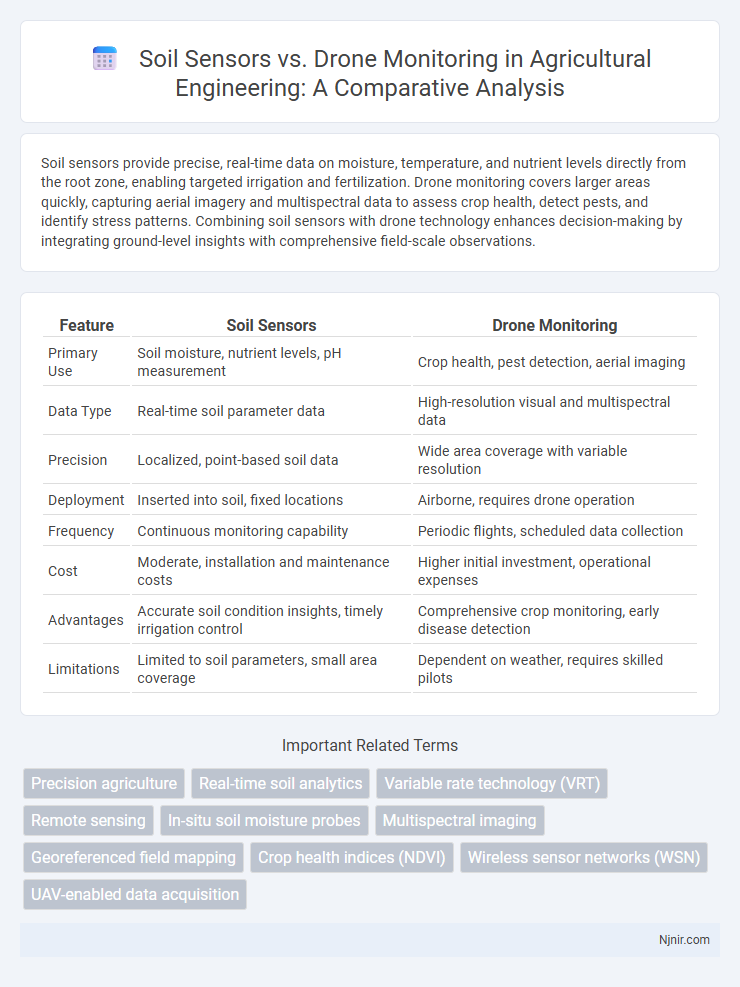
Soil sensors provide precise, real-time data on moisture, temperature, and nutrient levels directly from the root zone, enabling targeted irrigation and fertilization. Drone monitoring covers larger areas quickly, capturing aerial imagery and multispectral data to assess crop health, detect pests, and identify stress patterns. Combining soil sensors with drone technology enhances decision-making by integrating ground-level insights with comprehensive field-scale observations.
Table of Comparison
| Feature | Soil Sensors | Drone Monitoring |
|---|---|---|
| Primary Use | Soil moisture, nutrient levels, pH measurement | Crop health, pest detection, aerial imaging |
| Data Type | Real-time soil parameter data | High-resolution visual and multispectral data |
| Precision | Localized, point-based soil data | Wide area coverage with variable resolution |
| Deployment | Inserted into soil, fixed locations | Airborne, requires drone operation |
| Frequency | Continuous monitoring capability | Periodic flights, scheduled data collection |
| Cost | Moderate, installation and maintenance costs | Higher initial investment, operational expenses |
| Advantages | Accurate soil condition insights, timely irrigation control | Comprehensive crop monitoring, early disease detection |
| Limitations | Limited to soil parameters, small area coverage | Dependent on weather, requires skilled pilots |
Introduction to Precision Agriculture Technologies
Soil sensors provide real-time data on moisture, nutrient levels, and soil temperature, enabling targeted irrigation and fertilization to enhance crop yield. Drone monitoring offers aerial imagery and multispectral data for large-scale crop health assessment, pest detection, and field mapping. Precision agriculture integrates these technologies to optimize resource use, reduce environmental impact, and improve farm productivity.
Overview of Soil Sensors: Capabilities and Applications
Soil sensors offer precise, real-time data on moisture levels, nutrient content, and pH, enabling targeted irrigation and fertilization to optimize crop yields. These devices measure parameters such as temperature and electrical conductivity, providing insights for soil health management and early detection of stress conditions. Widely applied in precision agriculture, soil sensors improve water efficiency and reduce input costs by delivering localized, actionable data directly from the root zone.
Drone Monitoring in Agriculture: Key Features and Uses
Drone monitoring in agriculture offers precise, high-resolution aerial imagery that captures crop health, soil conditions, and irrigation status across vast fields quickly and efficiently. Equipped with multispectral, thermal, and RGB cameras, drones enable real-time data collection for early detection of pest infestations, nutrient deficiencies, and water stress, enhancing decision-making and crop management. The integration of drone data with GPS and GIS technologies facilitates accurate mapping, yield prediction, and targeted application of fertilizers and pesticides, optimizing resource use and increasing farm productivity.
Data Accuracy: Soil Sensors versus Drones
Soil sensors provide precise, real-time data on moisture levels, temperature, and nutrient content directly from the root zone, ensuring high accuracy and localized insights. Drone monitoring offers broader spatial coverage with multispectral imaging and aerial data collection but may lack the granularity and immediate feedback that soil sensors deliver. The integration of soil sensors with drone data enhances overall precision in crop monitoring and resource management by combining detailed ground-level metrics with expansive aerial perspectives.
Deployment Costs and Maintenance Considerations
Soil sensors require lower upfront deployment costs compared to drone monitoring systems, as they involve installing relatively inexpensive hardware directly in the field for continuous data collection. Maintenance of soil sensors is minimal but requires periodic calibration and battery replacements, ensuring consistent accuracy over time. In contrast, drone monitoring demands higher initial investment in equipment and software, along with ongoing costs for skilled operation, battery charging, and regular hardware maintenance.
Spatial Coverage and Data Granularity
Soil sensors provide high data granularity by continuously measuring specific soil parameters like moisture, temperature, and nutrient levels at fixed locations, enabling precise, localized analysis. Drone monitoring offers expansive spatial coverage through aerial imaging, capturing real-time vegetation health and field variability over large agricultural areas. Combining soil sensors' detailed point data with drones' broad spatial insights enhances overall farm management efficiency and decision-making accuracy.
Integration with Farm Management Systems
Soil sensors provide precise, real-time data on moisture, nutrient levels, and pH directly from the ground, enabling seamless integration with farm management systems for targeted irrigation and fertilization. Drone monitoring complements this by offering aerial imaging and crop health analysis, which can be layered with soil sensor data in farm management platforms to enhance decision-making accuracy. Combining these technologies within integrated systems maximizes resource efficiency and crop yield through data-driven farm management.
Real-Time Decision-Making: Sensors vs Drone Data
Soil sensors provide continuous, real-time data on moisture, temperature, and nutrient levels directly from the root zone, enabling immediate, precise adjustments for irrigation and fertilization. Drone monitoring captures high-resolution aerial imagery and multispectral data at scheduled intervals, offering broader spatial insights but with delayed real-time applicability. Combining sensor data with drone imagery enhances decision-making efficiency by integrating localized ground metrics and comprehensive crop health assessments.
Environmental Impact and Sustainability
Soil sensors provide precise data on moisture levels, nutrient content, and pH, enabling targeted irrigation and fertilization that reduce water waste and chemical runoff, thus minimizing environmental impact. Drone monitoring offers large-scale aerial surveillance to detect crop stress, pest infestations, and soil erosion early, facilitating timely interventions that sustain soil health and biodiversity. Integrating both technologies enhances sustainable agriculture by optimizing resource use, reducing carbon footprint, and promoting eco-friendly farming practices.
Future Trends: Combining Soil Sensors and Drone Monitoring
Future trends in agriculture emphasize integrating soil sensors and drone monitoring for precision farming, enabling real-time data collection on soil moisture, nutrient levels, and crop health. Combining these technologies enhances decision-making through detailed spatial analysis, leading to optimized irrigation, fertilization, and yield prediction. Advances in AI and machine learning further improve data interpretation, fostering sustainable farming practices and resource efficiency.
Precision agriculture
Soil sensors provide real-time, high-resolution data on moisture and nutrient levels, while drone monitoring offers aerial imaging for crop health and spatial variability, together enhancing precision agriculture by enabling timely, site-specific management decisions.
Real-time soil analytics
Soil sensors provide precise, real-time soil analytics by measuring moisture, temperature, and nutrient levels directly in the field, whereas drone monitoring offers broader spatial data but with less immediate soil-specific insights.
Variable rate technology (VRT)
Variable Rate Technology (VRT) enhances precision agriculture by integrating soil sensors' real-time data on moisture and nutrient levels with drone monitoring's aerial imagery to optimize input applications and improve crop yields.
Remote sensing
Soil sensors provide precise in-situ data on moisture and nutrient levels, whereas drone monitoring offers expansive remote sensing capabilities to assess crop health and soil conditions across large agricultural fields.
In-situ soil moisture probes
In-situ soil moisture probes offer precise, real-time soil hydration data directly within the root zone, outperforming drone monitoring by providing continuous, localized measurements essential for optimized irrigation management.
Multispectral imaging
Multispectral imaging via drone monitoring provides high-resolution, real-time crop health data, while soil sensors deliver precise, ground-level moisture and nutrient measurements, each enhancing precision agriculture through complementary insights.
Georeferenced field mapping
Soil sensors provide precise georeferenced field mapping by continuously monitoring soil conditions at specific locations, while drone monitoring offers high-resolution aerial imagery that complements soil data for comprehensive spatial analysis.
Crop health indices (NDVI)
Soil sensors provide real-time, localized data on moisture and nutrients essential for crop health, while drone monitoring captures comprehensive NDVI imagery to assess crop vitality and detect stress across large fields efficiently.
Wireless sensor networks (WSN)
Wireless sensor networks (WSN) in soil sensors provide real-time, precise soil data, enabling targeted monitoring and resource-efficient agriculture, while drones offer broader aerial surveillance but lack the continuous, ground-level specificity of WSN.
UAV-enabled data acquisition
UAV-enabled data acquisition enhances drone monitoring by capturing high-resolution soil sensor data across large agricultural fields for precise crop management.
Soil sensors vs Drone monitoring Infographic