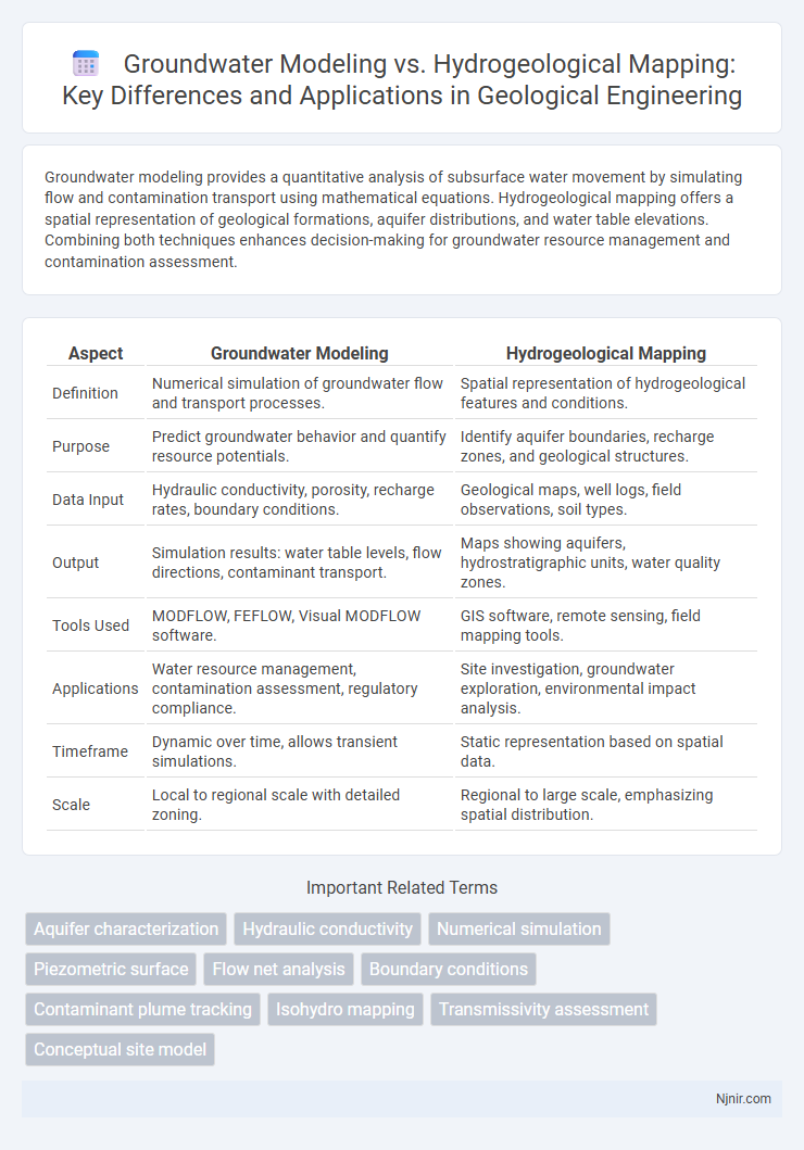
Groundwater modeling provides a quantitative analysis of subsurface water movement by simulating flow and contamination transport using mathematical equations. Hydrogeological mapping offers a spatial representation of geological formations, aquifer distributions, and water table elevations. Combining both techniques enhances decision-making for groundwater resource management and contamination assessment.
Table of Comparison
| Aspect | Groundwater Modeling | Hydrogeological Mapping |
|---|---|---|
| Definition | Numerical simulation of groundwater flow and transport processes. | Spatial representation of hydrogeological features and conditions. |
| Purpose | Predict groundwater behavior and quantify resource potentials. | Identify aquifer boundaries, recharge zones, and geological structures. |
| Data Input | Hydraulic conductivity, porosity, recharge rates, boundary conditions. | Geological maps, well logs, field observations, soil types. |
| Output | Simulation results: water table levels, flow directions, contaminant transport. | Maps showing aquifers, hydrostratigraphic units, water quality zones. |
| Tools Used | MODFLOW, FEFLOW, Visual MODFLOW software. | GIS software, remote sensing, field mapping tools. |
| Applications | Water resource management, contamination assessment, regulatory compliance. | Site investigation, groundwater exploration, environmental impact analysis. |
| Timeframe | Dynamic over time, allows transient simulations. | Static representation based on spatial data. |
| Scale | Local to regional scale with detailed zoning. | Regional to large scale, emphasizing spatial distribution. |
Introduction to Groundwater Evaluation Techniques
Groundwater modeling involves creating computational simulations to predict subsurface water flow and contaminant transport, utilizing data such as hydraulic conductivity, porosity, and aquifer geometry. Hydrogeological mapping provides spatial representation of groundwater conditions by integrating geological formations, water table elevations, and recharge/discharge zones. Both techniques are essential in groundwater evaluation, offering quantitative analysis through models and qualitative insights via geological mapping for sustainable water resource management.
Overview of Groundwater Modeling
Groundwater modeling involves the use of numerical simulations to predict the behavior and movement of groundwater within aquifers under various conditions, integrating data such as hydraulic conductivity, recharge rates, and boundary conditions. It provides valuable quantitative insights for water resource management, contamination assessment, and wellfield design. In contrast, hydrogeological mapping focuses on the spatial distribution and characterization of groundwater features, including water table contours, aquifer extents, and lithological properties.
Fundamentals of Hydrogeological Mapping
Hydrogeological mapping involves the detailed representation of groundwater occurrence, flow patterns, and aquifer properties through geospatial techniques and field data integration. It serves as a fundamental tool in identifying recharge zones, discharge areas, and subsurface hydrostratigraphy essential for sustainable groundwater management. Unlike groundwater modeling, which simulates flow and contaminant transport quantitatively, hydrogeological mapping provides the qualitative groundwork necessary for developing accurate numerical models.
Key Objectives: Modeling vs. Mapping
Groundwater modeling aims to simulate subsurface water flow, recharge, and contaminant transport to predict future aquifer behavior under varying conditions. Hydrogeological mapping focuses on delineating spatial distribution of aquifers, geological formations, and hydrogeological properties through field data and geospatial analysis. Modeling supports quantitative analysis and scenario testing, while mapping provides essential geological context and boundary conditions for such models.
Data Requirements and Collection Methods
Groundwater modeling requires quantitative data such as hydraulic conductivity, porosity, recharge rates, and groundwater levels collected through methods like pumping tests, piezometer monitoring, and geophysical surveys to simulate subsurface flow accurately. Hydrogeological mapping relies on spatial data collection, including lithological logs, well locations, and surface water interactions, gathered via field mapping, remote sensing, and borehole logging to delineate aquifer boundaries and hydrostratigraphic units. Both techniques necessitate high-quality datasets, but groundwater modeling emphasizes dynamic hydrological parameters while hydrogeological mapping prioritizes geological and spatial distribution information.
Tools and Software in Groundwater Analysis
Groundwater modeling relies heavily on advanced software such as MODFLOW, FEFLOW, and GMS for simulating groundwater flow and contaminant transport, enabling quantitative analysis and prediction of aquifer behavior. Hydrogeological mapping typically employs GIS platforms including ArcGIS and QGIS to integrate spatial data, visualize hydrogeological features, and support qualitative assessments of groundwater conditions. Both tools enhance groundwater analysis, but modeling software focuses on dynamic simulations while mapping tools prioritize spatial representation and data integration.
Spatial Resolution and Accuracy Comparison
Groundwater modeling uses numerical simulations to predict subsurface water flow, offering high spatial resolution by integrating diverse data sources such as well logs, geophysical surveys, and hydraulic conductivity measurements. Hydrogeological mapping primarily relies on field observations and geological data to depict aquifer extents and recharge zones, providing broader spatial coverage but lower resolution compared to modeling. Accuracy in groundwater modeling is enhanced by calibration with observed data, whereas hydrogeological mapping accuracy depends on the density and quality of field data, often resulting in coarser spatial detail.
Applications in Geological Engineering Projects
Groundwater modeling provides quantitative simulations of subsurface water flow and contaminant transport, essential for designing sustainable extraction and remediation strategies in geological engineering projects. Hydrogeological mapping offers spatial visualization of aquifer properties, recharge zones, and groundwater availability, critical for site characterization and risk assessment during infrastructure development. Both tools complement each other by integrating numerical data with spatial analysis to optimize groundwater resource management and hazard mitigation in complex geotechnical environments.
Limitations and Challenges of Each Approach
Groundwater modeling faces limitations such as data scarcity, model uncertainty, and high computational demands, making it challenging to accurately predict complex subsurface flow patterns. Hydrogeological mapping, while useful for visualizing surface and subsurface features, often struggles with spatial resolution constraints and the inability to capture dynamic changes in groundwater systems over time. Both approaches require comprehensive field data and integration with advanced geospatial technologies to overcome these inherent challenges and improve groundwater resource management.
Integrating Groundwater Modeling with Hydrogeological Mapping
Integrating groundwater modeling with hydrogeological mapping enhances aquifer characterization by combining spatial data on geological formations with numerical simulations of groundwater flow and contaminant transport. This integration improves the accuracy of predicting water table fluctuations, recharge rates, and contaminant plumes by aligning hydrogeological features such as permeability and stratigraphy with model parameters. Effective collaboration between these methodologies supports sustainable groundwater management by providing comprehensive insights into aquifer behavior and vulnerability.
Aquifer characterization
Groundwater modeling provides quantitative simulations of aquifer flow dynamics and storage properties, while hydrogeological mapping offers spatial visualization of aquifer boundaries, lithology, and recharge zones essential for comprehensive aquifer characterization.
Hydraulic conductivity
Hydraulic conductivity in groundwater modeling quantifies the rate at which water moves through aquifer materials, while hydrogeological mapping spatially represents hydraulic conductivity variations to delineate groundwater flow patterns.
Numerical simulation
Numerical simulation in groundwater modeling provides dynamic, quantitative predictions of subsurface flow and contaminant transport, while hydrogeological mapping primarily offers spatial visualization of geological and hydrological features without temporal or predictive capabilities.
Piezometric surface
Groundwater modeling quantitatively simulates piezometric surface variations using numerical data, while hydrogeological mapping visually represents piezometric surface contours based on field measurements.
Flow net analysis
Flow net analysis in groundwater modeling quantifies subsurface water flow patterns and hydraulic gradients, while hydrogeological mapping visualizes spatial distribution of groundwater features without detailed flow quantification.
Boundary conditions
Groundwater modeling precisely quantifies boundary conditions to simulate flow dynamics, whereas hydrogeological mapping qualitatively identifies boundary features to delineate aquifer extents.
Contaminant plume tracking
Groundwater modeling quantitatively predicts contaminant plume movement and concentration over time, while hydrogeological mapping qualitatively delineates subsurface features influencing plume pathways for effective contaminant tracking.
Isohydro mapping
Isohydro mapping in hydrogeological mapping visually represents groundwater level contours, offering spatial context, while groundwater modeling simulates dynamic flow and predicts future conditions using numerical data.
Transmissivity assessment
Groundwater modeling provides dynamic simulations to estimate aquifer transmissivity values over time, while hydrogeological mapping offers spatial distribution insights of transmissivity based on field measurements and geological data.
Conceptual site model
Groundwater modeling quantitatively simulates subsurface flow based on data-driven parameters, while hydrogeological mapping visually represents spatial distribution of geological features; both integrate into a conceptual site model to accurately characterize site-specific hydrogeology and support risk assessment.
Groundwater modeling vs Hydrogeological mapping Infographic