Geophysical engineering involves the use of remote sensing and subsurface imaging techniques such as seismic, magnetic, and electrical methods to analyze the Earth's physical properties. Geotechnical engineering focuses on the mechanical behavior of soil and rock materials, applying principles of soil mechanics and rock mechanics to design foundations, slopes, and earth structures. Both disciplines complement each other by providing critical data for safe and efficient civil engineering projects, with geophysical methods offering non-invasive site characterization and geotechnical methods delivering detailed soil and rock analysis.
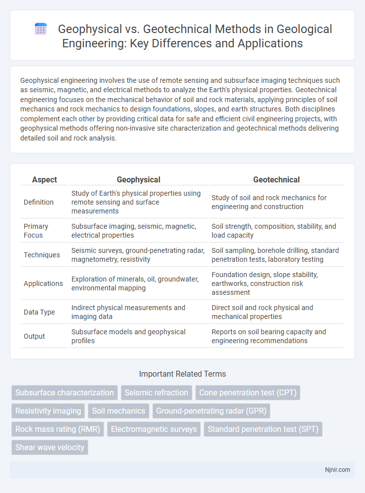
Table of Comparison
| Aspect | Geophysical | Geotechnical |
|---|---|---|
| Definition | Study of Earth's physical properties using remote sensing and surface measurements | Study of soil and rock mechanics for engineering and construction |
| Primary Focus | Subsurface imaging, seismic, magnetic, electrical properties | Soil strength, composition, stability, and load capacity |
| Techniques | Seismic surveys, ground-penetrating radar, magnetometry, resistivity | Soil sampling, borehole drilling, standard penetration tests, laboratory testing |
| Applications | Exploration of minerals, oil, groundwater, environmental mapping | Foundation design, slope stability, earthworks, construction risk assessment |
| Data Type | Indirect physical measurements and imaging data | Direct soil and rock physical and mechanical properties |
| Output | Subsurface models and geophysical profiles | Reports on soil bearing capacity and engineering recommendations |
Introduction to Geophysical and Geotechnical Engineering
Geophysical engineering involves the application of physical methods such as seismic, magnetic, and electrical techniques to investigate subsurface conditions, primarily focusing on the earth's physical properties. Geotechnical engineering centers on analyzing soil and rock mechanics to design foundations, retaining structures, and earthworks, emphasizing material behavior under stress. Both disciplines integrate site characterization to ensure safe and efficient engineering design, with geophysics providing non-invasive data and geotechnical engineering applying that data for practical construction solutions.
Key Principles of Geophysical Techniques
Geophysical techniques rely on measuring physical properties such as seismic velocity, electrical resistivity, and magnetic susceptibility to infer subsurface conditions, emphasizing non-invasive data acquisition and spatial continuity. These methods utilize wave propagation, electromagnetic fields, and gravitational variations to detect anomalies and heterogeneities in earth materials, providing a comprehensive picture of geological structures. Accurate interpretation hinges on understanding signal attenuation, wave refraction, and the contrast between target materials and host media to optimize site characterization and resource evaluation.
Core Concepts in Geotechnical Investigations
Geophysical methods in geotechnical investigations primarily involve non-invasive techniques such as seismic refraction, electrical resistivity, and ground-penetrating radar to characterize subsurface conditions and identify soil layers, rock formations, and groundwater presence. Geotechnical investigations focus on direct sampling through boreholes, standard penetration tests (SPT), and laboratory tests to determine soil properties like shear strength, compressibility, and permeability essential for foundation design. Core concepts include assessing soil stratigraphy, evaluating load-bearing capacity, and identifying potential geohazards to ensure safe and cost-effective engineering solutions.
Comparison of Geophysical and Geotechnical Methods
Geophysical methods utilize non-invasive techniques such as seismic surveys, electrical resistivity, and ground-penetrating radar to assess subsurface conditions by measuring physical properties, whereas geotechnical methods involve direct sampling and laboratory testing of soil and rock to determine mechanical and engineering properties. Geophysical techniques offer rapid, larger-scale site characterization with minimal disturbance, making them ideal for preliminary investigations, while geotechnical approaches provide detailed, site-specific data critical for design and construction decisions. Integrating both methods enhances accuracy and reliability in assessing subsurface conditions for engineering, environmental, and construction projects.
Applications in Site Characterization
Geophysical methods, such as seismic refraction and ground-penetrating radar, provide non-invasive subsurface imaging useful for mapping soil layers, detecting groundwater, and identifying geological structures in site characterization. Geotechnical investigations involve direct sampling and testing of soil and rock properties, including shear strength, compressibility, and bearing capacity, critical for foundation design and slope stability analysis. Combining geophysical surveys with geotechnical testing offers comprehensive site characterization, improving the accuracy of subsurface condition assessments and construction risk evaluations.
Tools and Equipment: Geophysical vs Geotechnical Approaches
Geophysical methods utilize tools such as seismic sensors, ground-penetrating radar (GPR), and magnetometers to non-invasively analyze subsurface conditions by measuring physical properties like density, conductivity, and seismic velocity. Geotechnical approaches rely on equipment like borehole drill rigs, soil samplers, standard penetration test (SPT) devices, and cone penetration test (CPT) tools to directly collect soil and rock samples for mechanical and compositional analysis. While geophysical tools emphasize remote sensing and mapping large areas rapidly, geotechnical equipment provides precise, localized data crucial for foundation design and construction safety.
Data Interpretation and Accuracy
Geophysical data interpretation relies on analyzing subsurface properties through indirect measurements such as seismic, magnetic, or electrical signals, emphasizing pattern recognition and model fitting to achieve accurate geological imaging. Geotechnical data interpretation, on the other hand, involves direct sampling and testing of soil and rock properties, prioritizing precise laboratory and field test results like shear strength, permeability, and consolidation parameters for engineering design. Accuracy in geophysical methods depends on data resolution and inversion algorithms, whereas geotechnical accuracy depends on sample representativeness and standardized testing procedures.
Cost-effectiveness and Project Efficiency
Geophysical methods reduce project costs by providing rapid, non-invasive subsurface data that minimizes the need for extensive drilling and sampling, enhancing overall cost-effectiveness. Geotechnical investigations offer detailed site-specific soil and rock property information vital for safe design but often involve higher expenses and longer timelines due to laboratory testing and field sampling. Integrating geophysical surveys with targeted geotechnical testing improves project efficiency by optimizing resource allocation and reducing uncertainty in site characterization.
Limitations and Challenges
Geophysical methods face limitations in resolution and depth penetration, often producing ambiguous data that complicates subsurface characterization. Geotechnical investigations encounter challenges such as soil heterogeneity and scale effects, which impact the accuracy of in-situ testing and laboratory analyses. Both disciplines must address uncertainties in site conditions to ensure reliable engineering and environmental assessments.
Integrating Geophysical and Geotechnical Data for Geological Engineering
Integrating geophysical and geotechnical data enhances geological engineering by providing a comprehensive subsurface characterization that improves site investigation accuracy and risk assessment. Geophysical methods such as seismic refraction, resistivity, and ground-penetrating radar offer non-invasive insights into subsurface structures, while geotechnical data from boreholes and soil tests provide direct measurements of soil properties and behavior. Combining these datasets enables engineers to optimize foundation design, slope stability analysis, and groundwater flow modeling, ultimately reducing project costs and improving safety margins.
Subsurface characterization
Geophysical methods provide non-invasive subsurface characterization by measuring physical properties like seismic velocity and electrical resistivity, while geotechnical techniques involve direct sampling and testing of soil and rock to assess mechanical properties and strength.
Seismic refraction
Seismic refraction is a geophysical method used to determine subsurface layer properties by measuring seismic wave velocities, while geotechnical engineering applies these data to assess soil and rock stability for construction projects.
Cone penetration test (CPT)
Cone Penetration Test (CPT) is a geotechnical investigation method that provides continuous subsurface soil data by measuring resistance to penetration, whereas geophysical methods analyze soil properties indirectly through seismic or electrical signals.
Resistivity imaging
Resistivity imaging in geophysics provides detailed subsurface electrical property maps, while in geotechnical applications, it optimizes soil characterization and foundation assessment.
Soil mechanics
Geotechnical engineering applies soil mechanics principles to analyze soil behavior for foundation design, while geophysical methods use remote sensing techniques to investigate subsurface soil properties without direct sampling.
Ground-penetrating radar (GPR)
Ground-penetrating radar (GPR) is a geophysical method used to detect and map subsurface features by transmitting electromagnetic waves, whereas geotechnical investigations use physical soil sampling and mechanical testing to assess ground conditions.
Rock mass rating (RMR)
Rock Mass Rating (RMR) quantitatively evaluates rock mass quality through geotechnical parameters such as uniaxial compressive strength, joint spacing, and groundwater conditions, distinguishing it from geophysical methods that assess subsurface properties using seismic or resistivity data.
Electromagnetic surveys
Electromagnetic surveys in geophysical methods provide subsurface conductivity data crucial for identifying soil and rock properties, while geotechnical applications use this data to assess ground stability and support engineering designs.
Standard penetration test (SPT)
The Standard Penetration Test (SPT) in geotechnical engineering measures soil resistance to assess subsurface soil properties, while geophysical methods use non-invasive techniques to detect variations in soil and rock characteristics without direct sampling.
Shear wave velocity
Shear wave velocity measurements are crucial in geophysical surveys to assess subsurface stiffness and material properties, while in geotechnical engineering, shear wave velocity is used to evaluate soil strength and liquefaction potential.
geophysical vs geotechnical Infographic