Slope monitoring involves continuous observation of surface movements to detect potential landslides and ensure slope stability, utilizing tools like inclinometers and GPS sensors. Deformation analysis examines changes in shape, displacement, and strain within rock or soil masses to understand structural integrity and predict failure mechanisms. Integrating both methods enhances early warning systems and informs effective slope management strategies in geological engineering.
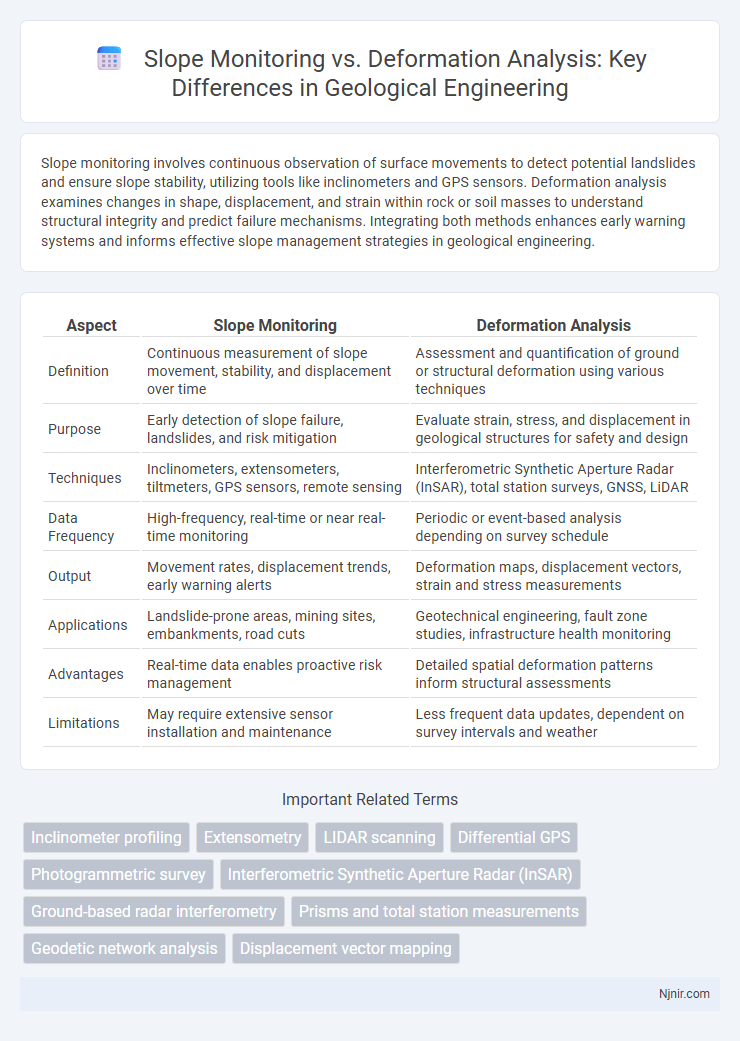
Table of Comparison
| Aspect | Slope Monitoring | Deformation Analysis |
|---|---|---|
| Definition | Continuous measurement of slope movement, stability, and displacement over time | Assessment and quantification of ground or structural deformation using various techniques |
| Purpose | Early detection of slope failure, landslides, and risk mitigation | Evaluate strain, stress, and displacement in geological structures for safety and design |
| Techniques | Inclinometers, extensometers, tiltmeters, GPS sensors, remote sensing | Interferometric Synthetic Aperture Radar (InSAR), total station surveys, GNSS, LiDAR |
| Data Frequency | High-frequency, real-time or near real-time monitoring | Periodic or event-based analysis depending on survey schedule |
| Output | Movement rates, displacement trends, early warning alerts | Deformation maps, displacement vectors, strain and stress measurements |
| Applications | Landslide-prone areas, mining sites, embankments, road cuts | Geotechnical engineering, fault zone studies, infrastructure health monitoring |
| Advantages | Real-time data enables proactive risk management | Detailed spatial deformation patterns inform structural assessments |
| Limitations | May require extensive sensor installation and maintenance | Less frequent data updates, dependent on survey intervals and weather |
Introduction to Slope Monitoring and Deformation Analysis
Slope monitoring involves continuous measurement of slope stability using instruments like inclinometers, piezometers, and ground-based radar to detect early signs of movement or failure in natural or engineered slopes. Deformation analysis examines changes in shape, position, or dimensions of geological or structural elements, utilizing remote sensing technologies such as LiDAR, GNSS, and photogrammetry to assess displacement patterns over time. Both techniques are critical for landslide risk management, infrastructure safety, and geotechnical engineering applications, providing complementary data for comprehensive slope behavior evaluation.
Importance of Slope Stability in Geological Engineering
Slope monitoring provides real-time data essential for detecting early signs of instability, while deformation analysis offers a comprehensive understanding of the long-term structural changes in slopes. The importance of slope stability in geological engineering lies in preventing landslides, ensuring the safety of infrastructure, and mitigating economic losses. Accurate assessment through both methods is critical for designing effective slope reinforcement and hazard management strategies.
Principles of Slope Monitoring Technologies
Slope monitoring technologies primarily use ground-based radar, GPS, and laser scanning to detect real-time displacement and changes in slope geometry, providing continuous data for hazard assessment. Deformation analysis integrates these measurements with geotechnical models to interpret subsurface movements and stress distribution, enhancing the understanding of slope stability. Key principles involve high-precision data acquisition, temporal resolution for trend detection, and spatial resolution to distinguish localized deformation zones.
Fundamentals of Geological Deformation Analysis
Slope monitoring relies on real-time data collection through sensors such as inclinometers, piezometers, and GPS to detect shifts and potential landslides, focusing on immediate hazard identification. Deformation analysis encompasses the study of strain accumulation, displacement patterns, and stress distribution within geological materials, using techniques like remote sensing, photogrammetry, and finite element modeling to understand the mechanics of rock and soil behavior over time. Fundamentals of geological deformation analysis emphasize characterizing strain tensors, rock rheology, and fault kinematics to predict failure mechanisms and assess long-term stability of slopes and structural formations.
Key Differences Between Slope Monitoring and Deformation Analysis
Slope monitoring primarily involves real-time tracking of slope stability using instruments such as inclinometers, piezometers, and ground-based radar to detect movement and potential failure zones. Deformation analysis focuses on the detailed measurement and interpretation of displacement patterns and strain in geological materials, employing techniques like GPS, LiDAR, and photogrammetry for precise spatial and temporal deformation data. The key differences lie in slope monitoring's emphasis on early warning and hazard prevention, while deformation analysis provides in-depth insights into the mechanisms driving ground movement and structural changes.
Instrumentation and Methods for Slope Monitoring
Slope monitoring relies heavily on real-time instrumentation such as inclinometers, extensometers, and piezometers to capture dynamic slope movements and groundwater pressure changes. Deformation analysis incorporates remote sensing techniques like LiDAR, photogrammetry, and satellite radar interferometry to measure subtle surface displacements over time. Combining these methods enhances slope stability assessment by providing comprehensive temporal and spatial deformation data critical for early warning systems and risk mitigation.
Analytical Approaches in Deformation Analysis
Analytical approaches in deformation analysis primarily utilize mathematical models such as finite element methods (FEM) and displacement vector analysis to quantify ground movement and stress distribution. Unlike slope monitoring, which relies on real-time sensor data like inclinometers and piezometers for early warning, analytical deformation techniques predict failure mechanisms by simulating material behavior under various load conditions. These methods enable detailed assessment of potential deformation patterns, supporting proactive risk management in geotechnical engineering.
Applications in Mining, Tunneling, and Infrastructure
Slope monitoring employs real-time sensors such as inclinometers and radar to detect minute movements in mining operations, ensuring early warning of landslides and pit wall failures. Deformation analysis uses satellite-based InSAR and ground-based LiDAR to measure cumulative structural changes over time in tunnels and critical infrastructure, aiding in long-term safety assessments. Both methodologies complement each other by addressing immediate hazards and gradual shifts crucial for optimizing stability management in mining, tunneling, and infrastructure projects.
Data Interpretation and Risk Assessment
Slope monitoring uses real-time data such as inclinometers and piezometers to detect early signs of slope instability, enabling immediate risk assessment and timely mitigation measures. Deformation analysis relies on periodic data from techniques like LiDAR and photogrammetry to evaluate cumulative movements over time, providing comprehensive insights into deformation patterns and structural integrity. Integrating both methods enhances data interpretation accuracy, improving predictive capabilities and reducing potential landslide hazards effectively.
Future Trends in Slope and Deformation Monitoring Techniques
Future trends in slope monitoring and deformation analysis emphasize the integration of advanced remote sensing technologies such as LiDAR, InSAR, and UAV photogrammetry for real-time, high-resolution data acquisition. The development of AI-driven predictive models enhances early warning systems by analyzing complex deformation patterns and slope stability factors with greater accuracy. Increasing use of IoT-enabled sensor networks and cloud-based platforms facilitates continuous, remote monitoring and data fusion, improving the reliability and spatial-temporal granularity of slope failure assessments.
Inclinometer profiling
Inclinometer profiling provides precise slope monitoring and deformation analysis by measuring subsurface lateral displacements to assess ground movement and structural stability.
Extensometry
Extensometry provides precise displacement measurements essential for slope monitoring and deformation analysis, enabling early detection of ground movements to prevent landslides.
LIDAR scanning
LiDAR scanning enhances slope monitoring by providing high-resolution 3D surface data for real-time deformation analysis, enabling precise detection of minute changes and early warning of potential slope failures.
Differential GPS
Differential GPS enhances slope monitoring accuracy by providing precise real-time positional data, enabling detailed deformation analysis to detect subtle ground movements and prevent landslides.
Photogrammetric survey
Photogrammetric surveys enable precise slope monitoring by capturing high-resolution imagery for 3D deformation analysis, facilitating early detection of ground movements and enhancing geotechnical risk management.
Interferometric Synthetic Aperture Radar (InSAR)
Interferometric Synthetic Aperture Radar (InSAR) provides high-precision slope monitoring by detecting subtle ground surface displacements, while deformation analysis uses InSAR data to quantify and model land deformation processes over time.
Ground-based radar interferometry
Ground-based radar interferometry enhances slope monitoring by providing precise, real-time deformation analysis for early detection of ground movement hazards.
Prisms and total station measurements
Prisms combined with total station measurements provide precise slope monitoring by detecting minute deformations and displacement trends, enabling accurate deformation analysis over time.
Geodetic network analysis
Geodetic network analysis for slope monitoring provides precise spatial measurements that enhance deformation analysis by detecting subtle ground movements and structural shifts in real time.
Displacement vector mapping
Displacement vector mapping provides precise quantification of slope monitoring by visually capturing spatial deformation patterns, enhancing deformation analysis accuracy for early landslide detection.
Slope monitoring vs Deformation analysis Infographic