Low Earth Orbit (LEO) satellites operate at altitudes between 160 to 2,000 kilometers, providing lower latency and higher resolution for Earth observation and communication applications. Geostationary Earth Orbit (GEO) satellites orbit at approximately 35,786 kilometers, enabling continuous coverage of specific regions ideal for weather monitoring and broadcast services. The choice between LEO and GEO depends on mission requirements such as latency, coverage area, and satellite lifespan.
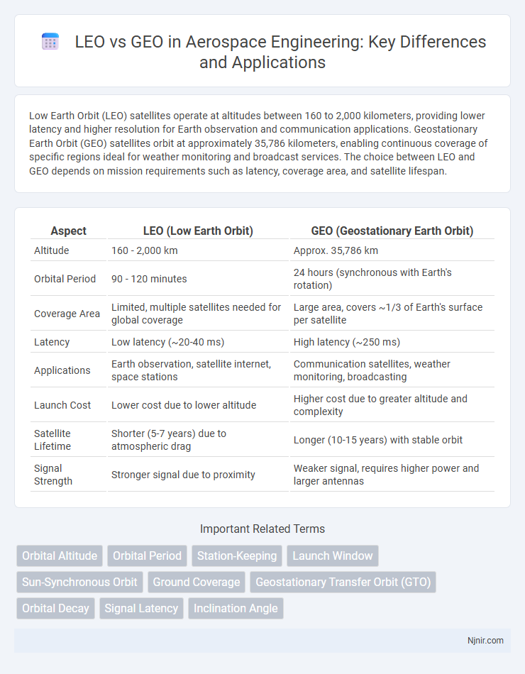
Table of Comparison
| Aspect | LEO (Low Earth Orbit) | GEO (Geostationary Earth Orbit) |
|---|---|---|
| Altitude | 160 - 2,000 km | Approx. 35,786 km |
| Orbital Period | 90 - 120 minutes | 24 hours (synchronous with Earth's rotation) |
| Coverage Area | Limited, multiple satellites needed for global coverage | Large area, covers ~1/3 of Earth's surface per satellite |
| Latency | Low latency (~20-40 ms) | High latency (~250 ms) |
| Applications | Earth observation, satellite internet, space stations | Communication satellites, weather monitoring, broadcasting |
| Launch Cost | Lower cost due to lower altitude | Higher cost due to greater altitude and complexity |
| Satellite Lifetime | Shorter (5-7 years) due to atmospheric drag | Longer (10-15 years) with stable orbit |
| Signal Strength | Stronger signal due to proximity | Weaker signal, requires higher power and larger antennas |
Introduction to LEO and GEO Orbits
LEO (Low Earth Orbit) typically ranges from 160 to 2,000 kilometers above Earth, offering low latency and high-resolution imaging ideal for satellite communication, Earth observation, and scientific missions. GEO (Geostationary Earth Orbit) is located approximately 35,786 kilometers above the equator, where satellites orbit synchronously with Earth's rotation, providing constant coverage over specific regions perfect for weather monitoring, broadcasting, and telecommunications. The distinct altitudes and orbital characteristics of LEO and GEO create diverse applications based on coverage, latency, and revisit times essential for satellite network design.
Key Differences Between LEO and GEO
Low Earth Orbit (LEO) satellites orbit at altitudes between 180 to 2,000 kilometers, enabling lower latency and faster data transmission compared to Geostationary Orbit (GEO) satellites positioned approximately 35,786 kilometers above the equator. GEO satellites provide continuous coverage over a fixed area, ideal for broadcasting and weather monitoring, whereas LEO satellites offer global coverage through a constellation system, optimizing real-time communication and Earth observation. The key differences also include lifespan and deployment costs, with GEO satellites typically lasting 15 years or more and costing significantly more to launch than LEO satellites, which have shorter lifespans around 5-7 years but are more cost-effective to deploy in large numbers.
Altitude and Coverage Comparison
LEO satellites orbit at altitudes between 500 to 2,000 kilometers, enabling lower latency and higher resolution coverage compared to GEO satellites, which orbit at approximately 35,786 kilometers above the equator. Due to their lower altitude, LEO satellites cover smaller surface areas per satellite but achieve global coverage through large constellations, whereas GEO satellites provide extensive coverage of about one-third of the Earth's surface from a single position. The proximity of LEO satellites reduces signal delay, making them ideal for real-time communication, whereas GEO satellites excel in broad, consistent coverage with fewer satellites.
Satellite Lifespan and Maintenance
LEO satellites typically have shorter lifespans of 5 to 7 years due to their proximity to Earth's atmosphere, which causes increased drag and orbital decay requiring more frequent maintenance or replacement. GEO satellites can operate for 15 years or more because they reside in a stable orbit approximately 35,786 kilometers above Earth, minimizing atmospheric drag and reducing fuel consumption for station-keeping. Maintenance for GEO satellites often involves complex station-keeping maneuvers using onboard thrusters to counteract gravitational perturbations, whereas LEO satellites may require more frequent deployments due to faster orbital degradation.
Communication Delay and Latency
LEO (Low Earth Orbit) satellites orbit at altitudes of 500 to 2,000 kilometers, resulting in significantly lower communication delays and latency, often under 50 milliseconds. GEO (Geostationary Earth Orbit) satellites orbit at approximately 35,786 kilometers, causing higher latency typically around 600 milliseconds due to the longer signal travel distance. This difference makes LEO satellites more suitable for real-time applications like video conferencing and online gaming, whereas GEO satellites are commonly used for broadcasting and satellite TV.
Applications of LEO Satellites
LEO (Low Earth Orbit) satellites, orbiting between 500 to 2,000 kilometers above Earth, excel in applications requiring low latency and high-resolution imaging, such as real-time Earth observation, environmental monitoring, and global broadband internet services exemplified by constellations like Starlink. Their proximity to Earth enables faster data transmission and reduced signal delay compared to GEO (Geostationary Earth Orbit) satellites positioned at approximately 35,786 kilometers, making LEO satellites ideal for time-sensitive communication and IoT networks. Furthermore, LEO satellites support dynamic coverage for disaster response, remote sensing, and mobile communications, expanding connectivity to underserved regions and enhancing global communication infrastructures.
Applications of GEO Satellites
GEO satellites provide critical support for telecommunications, broadcasting, and weather monitoring by maintaining a fixed position relative to the Earth's surface, enabling continuous coverage over specific areas. These satellites are essential for satellite TV, GPS augmentation, and real-time meteorological data collection that informs disaster response and climate studies. Their high-altitude orbit allows broad-area coverage with fewer satellites, optimizing infrastructure and operational cost efficiencies for global communication networks.
Cost Implications of LEO vs GEO
LEO satellites generally have lower launch costs due to their smaller size and reduced mass compared to GEO satellites, but require a larger constellation, increasing overall deployment and maintenance expenses. GEO satellites, despite higher individual launch and manufacturing costs, offer longer operational lifespans and require fewer satellites to cover global regions, potentially lowering long-term expenditures. Operational costs for LEO include frequent satellite replacements and ground infrastructure for tracking fast-moving satellites, while GEO's stable positioning simplifies ground systems and reduces tracking expenses.
Challenges and Limitations
LEO (Low Earth Orbit) satellites face challenges such as limited coverage area and the need for a large constellation to ensure continuous connectivity, leading to higher deployment and maintenance costs. GEO (Geostationary Earth Orbit) satellites encounter limitations including higher latency due to their approximately 35,786 kilometers altitude and signal degradation caused by atmospheric interference. Both orbits suffer from signal attenuation during adverse weather, but GEO satellites' fixed position simplifies ground equipment tracking compared to the fast-moving LEO satellites.
Future Trends in LEO and GEO Deployments
Future trends in LEO deployments emphasize mega-constellations with thousands of satellites, leveraging low latency and global coverage for enhanced broadband connectivity and IoT applications. GEO satellites continue to advance with high-throughput payloads and adaptive beamforming technologies, supporting broadcast services and critical communications over wide areas. Integration of LEO and GEO systems is expected to create hybrid networks, optimizing performance and resilience in global satellite communications.
Orbital Altitude
LEO satellites operate at orbital altitudes between 160 and 2,000 kilometers, providing lower latency and higher resolution, while GEO satellites orbit at approximately 35,786 kilometers, offering broader coverage but higher latency.
Orbital Period
LEO satellites orbit Earth approximately every 90 to 120 minutes, while GEO satellites maintain a fixed position with an orbital period of 24 hours matching Earth's rotation.
Station-Keeping
LEO satellites require more frequent and precise station-keeping maneuvers due to atmospheric drag, whereas GEO satellites primarily perform station-keeping to counteract gravitational perturbations and maintain orbital slot stability.
Launch Window
LEO satellites require frequent, often daily launch windows due to limited orbital slots and fast-moving orbits, while GEO satellites have more flexible launch windows aligned with geostationary positions and fewer orbital constraints.
Sun-Synchronous Orbit
LEO Sun-Synchronous Orbits provide consistent solar illumination for Earth observation satellites, contrasting with GEO orbits that maintain fixed positions relative to the Earth's surface but lack repeated solar angle conditions.
Ground Coverage
LEO satellites provide smaller ground coverage with lower latency ideal for high-speed data, while GEO satellites offer extensive ground coverage suitable for broad-area broadcasting and continuous communication.
Geostationary Transfer Orbit (GTO)
Geostationary Transfer Orbit (GTO) serves as an efficient intermediate orbit for satellites transitioning from Low Earth Orbit (LEO) to Geostationary Earth Orbit (GEO), enabling optimal fuel usage and precise insertion into geostationary slots critical for communication and weather satellites.
Orbital Decay
LEO satellites experience rapid orbital decay due to atmospheric drag, requiring frequent orbital adjustments, while GEO satellites maintain stable orbits with minimal decay over time.
Signal Latency
LEO satellites offer significantly lower signal latency, typically 20-40 milliseconds, compared to GEO satellites which have latency around 600 milliseconds due to their higher orbital altitude of approximately 35,786 kilometers.
Inclination Angle
LEO satellites typically have inclination angles ranging from 0deg to 98deg, allowing global coverage including polar regions, while GEO satellites maintain a fixed 0deg inclination to remain geostationary above the equator.
LEO vs GEO Infographic