Slope mapping involves the detailed analysis and classification of terrain inclinations to identify potential instability zones, essential for understanding the physical characteristics of an area. Hazard mapping extends beyond slope information by integrating factors such as soil type, water saturation, seismic activity, and human impact to predict and visualize risk areas for landslides, erosion, or structural failure. Combining both approaches enhances geological engineering projects by enabling comprehensive risk assessment and informed decision-making for land use planning and mitigation strategies.
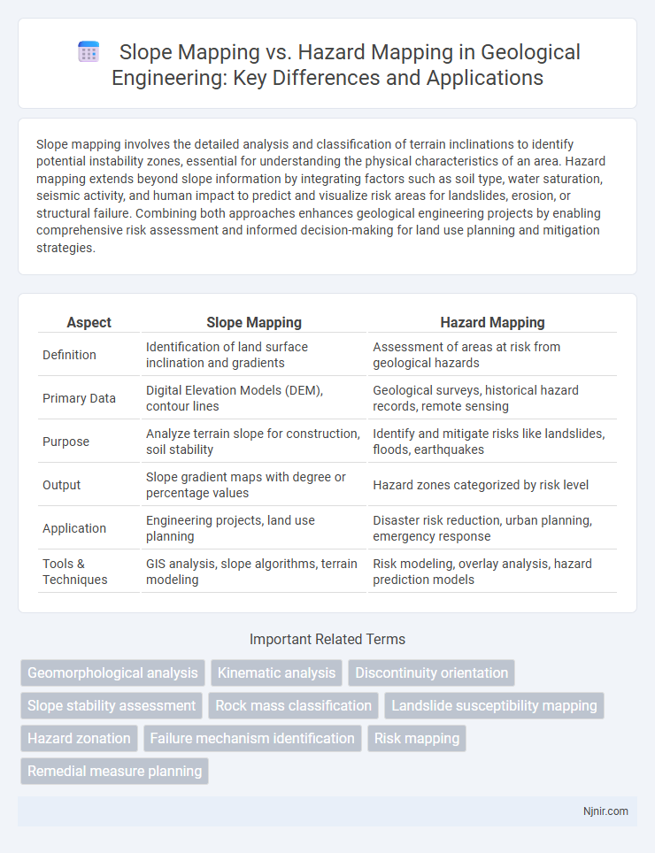
Table of Comparison
| Aspect | Slope Mapping | Hazard Mapping |
|---|---|---|
| Definition | Identification of land surface inclination and gradients | Assessment of areas at risk from geological hazards |
| Primary Data | Digital Elevation Models (DEM), contour lines | Geological surveys, historical hazard records, remote sensing |
| Purpose | Analyze terrain slope for construction, soil stability | Identify and mitigate risks like landslides, floods, earthquakes |
| Output | Slope gradient maps with degree or percentage values | Hazard zones categorized by risk level |
| Application | Engineering projects, land use planning | Disaster risk reduction, urban planning, emergency response |
| Tools & Techniques | GIS analysis, slope algorithms, terrain modeling | Risk modeling, overlay analysis, hazard prediction models |
Introduction to Geological Mapping in Engineering
Slope mapping identifies and categorizes the gradient and stability of terrain surfaces, critical for assessing potential landslide risks in engineering projects. Hazard mapping integrates geological data with environmental factors to delineate areas prone to natural disasters such as earthquakes, floods, or rockfalls, guiding risk mitigation strategies. Both mapping techniques provide essential spatial information for geotechnical analysis and infrastructure design in engineering geology.
Defining Slope Mapping in Geological Engineering
Slope mapping in geological engineering involves the detailed analysis and representation of terrain inclination and surface gradients to assess stability and potential landslide risks. This process utilizes digital elevation models (DEMs), field surveys, and geotechnical data to quantify slope angles, aspect, and morphological features critical for engineering design and hazard prediction. In contrast, hazard mapping integrates slope data with additional environmental factors to identify and categorize areas prone to various natural hazards such as floods, earthquakes, or mass movements.
Principles of Hazard Mapping
Hazard mapping involves identifying and assessing risks from natural or human-made hazards by analyzing factors such as terrain, weather, and land use patterns to predict potential impact zones. Slope mapping specifically examines land inclinations and stability to evaluate the likelihood of landslides or erosion, serving as a crucial input for comprehensive hazard maps. Principles of hazard mapping emphasize accuracy, spatial resolution, and integration of multi-disciplinary data to effectively delineate hazard-prone areas and support disaster risk reduction strategies.
Key Differences Between Slope Mapping and Hazard Mapping
Slope mapping primarily focuses on identifying and representing the gradient or incline of terrain surfaces using elevation data, aiding in landform analysis and engineering projects. Hazard mapping centers on analyzing and illustrating areas prone to natural or anthropogenic risks such as floods, landslides, or earthquakes, integrating multiple environmental and geospatial factors to assess vulnerability. The key difference lies in slope mapping's focus on terrain steepness as a physical parameter, while hazard mapping evaluates risk levels by combining slope with other hazard indicators and historical data.
Data Collection Techniques for Slope Mapping
Slope mapping relies heavily on data collection techniques such as satellite imagery, LiDAR (Light Detection and Ranging), and ground-based surveys using total stations or GPS to accurately capture terrain elevation and gradient. High-resolution digital elevation models (DEMs) derived from these data sources enable precise identification of slope angles and morphological features critical for assessing landslide risk. This contrasts with hazard mapping, which integrates slope data with additional environmental factors like soil type, vegetation cover, and rainfall intensity to evaluate potential threat zones.
Data Analysis Methods in Hazard Mapping
Hazard mapping employs advanced data analysis methods such as Geographic Information Systems (GIS), remote sensing, and statistical modeling to integrate multi-source data including topography, soil type, and historical event records for risk assessment. Techniques like fuzzy logic, machine learning algorithms, and spatial interpolation enhance the precision of hazard predictions by analyzing complex environmental variables and temporal patterns. In contrast, slope mapping primarily utilizes digital elevation models (DEMs) and terrain analysis to assess gradient and stability, serving as a foundational dataset for broader hazard assessments.
Applications of Slope Mapping in Engineering Projects
Slope mapping plays a critical role in engineering projects by providing detailed information on terrain inclination that guides foundation design, road construction, and slope stability analysis. It enables engineers to identify areas susceptible to landslides, optimize cut and fill operations, and minimize excavation costs while enhancing safety. Unlike hazard mapping, which focuses on assessing potential disaster risks, slope mapping delivers precise gradient data essential for structural integrity and site planning.
Risk Evaluation Through Hazard Mapping
Slope mapping identifies terrain inclination to assess landslide susceptibility, while hazard mapping integrates multiple data sources to delineate areas prone to natural disasters. Risk evaluation through hazard mapping incorporates exposure, vulnerability, and hazard probability, providing a comprehensive framework for disaster preparedness and mitigation. Hazard maps enable authorities to prioritize high-risk zones, optimize resource allocation, and implement effective early warning systems.
Integrating Slope and Hazard Mapping for Site Assessment
Integrating slope mapping with hazard mapping enhances site assessment by combining terrain analysis with risk identification, providing a comprehensive understanding of potential geohazards such as landslides, erosion, and flooding. Utilizing high-resolution digital elevation models (DEMs) alongside hazard maps developed from historical event data allows for precise identification of vulnerable zones and informs mitigation strategies. This integration supports urban planning, infrastructure development, and disaster risk reduction by enabling targeted interventions based on both slope stability and hazard susceptibility.
Best Practices and Future Trends in Geological Hazard Mapping
Slope mapping involves analyzing terrain angles to identify areas prone to landslides and erosion, utilizing high-resolution digital elevation models (DEMs) and remote sensing data for precise slope classification. Hazard mapping integrates multi-parameter data, including slope stability, soil type, rainfall patterns, and seismic activity, to produce comprehensive risk assessments that guide land use planning and disaster preparedness. Future trends emphasize the adoption of machine learning algorithms and real-time sensor networks to enhance predictive accuracy and enable dynamic updating of geological hazard maps.
Geomorphological analysis
Slope mapping quantifies terrain steepness and gradient variations, while hazard mapping integrates geomorphological analysis to identify and assess potential landslide, erosion, and flood risks based on slope stability and geological features.
Kinematic analysis
Kinematic analysis in slope mapping evaluates slope stability by assessing potential movements and failure mechanisms, whereas hazard mapping integrates these analyses to identify and spatially represent areas at risk of landslides and other mass movements.
Discontinuity orientation
Slope mapping analyzes overall terrain angles while hazard mapping prioritizes discontinuity orientation to assess potential failure surfaces and stability risks.
Slope stability assessment
Slope stability assessment prioritizes slope mapping to analyze terrain geometry and identify potential failure zones, while hazard mapping integrates slope data with environmental and human factors to evaluate and communicate overall risk levels.
Rock mass classification
Rock mass classification in slope mapping identifies geological conditions influencing stability, while hazard mapping assesses potential risk zones by integrating slope data with environmental factors.
Landslide susceptibility mapping
Slope mapping identifies terrain steepness, while hazard mapping integrates slope data with geological, hydrological, and land use factors to produce comprehensive landslide susceptibility maps.
Hazard zonation
Hazard zonation involves classifying areas based on potential risk levels using hazard mapping techniques that integrate slope mapping data to assess landslide susceptibility and other geological threats.
Failure mechanism identification
Slope mapping emphasizes identifying terrain gradients to assess instability risk, while hazard mapping integrates failure mechanisms such as landslides, rockfalls, and debris flows for comprehensive failure mechanism identification.
Risk mapping
Risk mapping integrates hazard mapping and slope mapping to identify areas vulnerable to natural disasters, enhancing targeted mitigation and land-use planning.
Remedial measure planning
Slope mapping identifies unstable terrain prone to landslides, while hazard mapping delineates risk zones integrating multiple factors, enabling precise remedial measure planning for effective slope stabilization and disaster mitigation.
Slope mapping vs Hazard mapping Infographic