Drone surveying offers rapid, high-resolution aerial data collection over large or inaccessible areas, significantly enhancing efficiency compared to terrestrial surveying. While terrestrial surveying provides precise, ground-level measurements ideal for detailed site analysis, drones integrate GPS and imaging technology to deliver comprehensive topographic maps and 3D models swiftly. Combining drone surveys with traditional terrestrial methods optimizes accuracy and reduces project timelines in civil engineering applications.
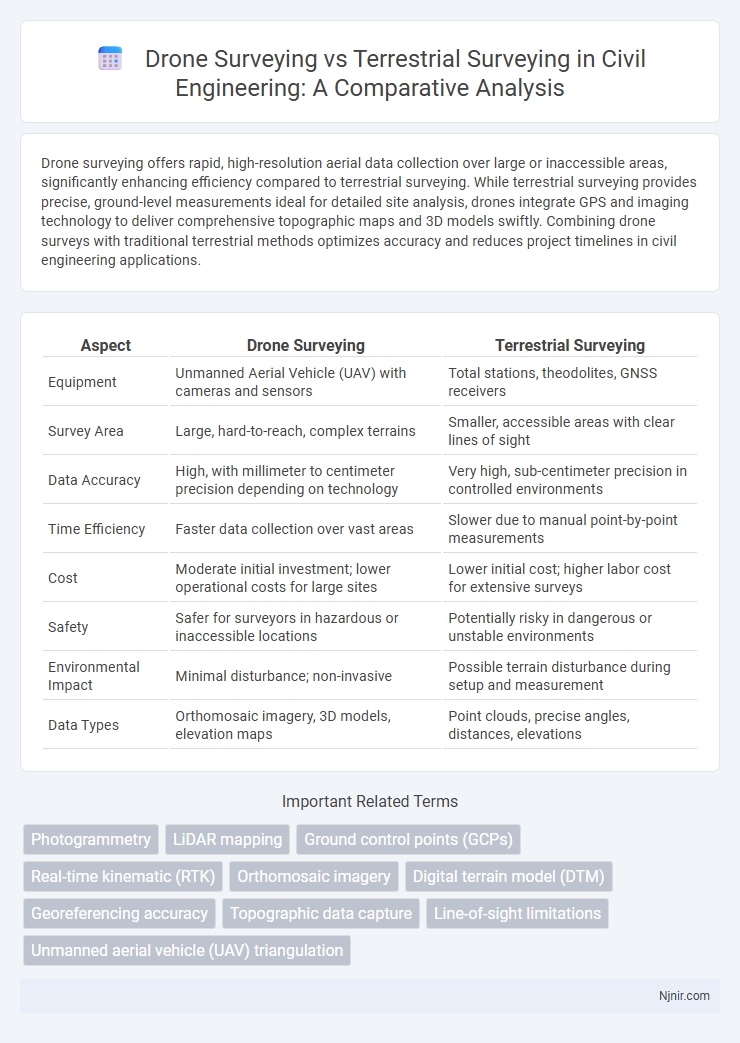
Table of Comparison
| Aspect | Drone Surveying | Terrestrial Surveying |
|---|---|---|
| Equipment | Unmanned Aerial Vehicle (UAV) with cameras and sensors | Total stations, theodolites, GNSS receivers |
| Survey Area | Large, hard-to-reach, complex terrains | Smaller, accessible areas with clear lines of sight |
| Data Accuracy | High, with millimeter to centimeter precision depending on technology | Very high, sub-centimeter precision in controlled environments |
| Time Efficiency | Faster data collection over vast areas | Slower due to manual point-by-point measurements |
| Cost | Moderate initial investment; lower operational costs for large sites | Lower initial cost; higher labor cost for extensive surveys |
| Safety | Safer for surveyors in hazardous or inaccessible locations | Potentially risky in dangerous or unstable environments |
| Environmental Impact | Minimal disturbance; non-invasive | Possible terrain disturbance during setup and measurement |
| Data Types | Orthomosaic imagery, 3D models, elevation maps | Point clouds, precise angles, distances, elevations |
Introduction to Surveying Methods in Civil Engineering
Drone surveying offers high-resolution aerial data collection with rapid coverage and enhanced safety for large or inaccessible sites, while terrestrial surveying provides precise ground-level measurements crucial for detailed topographic maps and structural assessments. Civil engineering projects often integrate both methods to optimize accuracy, efficiency, and cost-effectiveness in site analysis, infrastructure design, and construction monitoring. Advancements in UAV technology and GNSS integration have significantly improved the spatial data quality and processing speed in drone surveying compared to traditional terrestrial techniques.
Overview of Drone Surveying Technology
Drone surveying technology uses unmanned aerial vehicles (UAVs) equipped with high-resolution cameras and LiDAR sensors to capture precise geospatial data quickly over large areas. This method enables detailed 3D mapping, orthomosaic imagery, and real-time data processing, offering higher accuracy and efficiency compared to traditional terrestrial surveying. Enhanced GPS integration and automated flight paths further optimize data collection, making drone surveying ideal for topographic surveys, construction site monitoring, and environmental assessments.
Fundamentals of Terrestrial Surveying
Terrestrial surveying relies on ground-based measurements using equipment like total stations, theodolites, and levels to establish precise reference points and calculate distances, angles, and elevations. This method emphasizes line-of-sight observations and physical traverses, ensuring high accuracy in topographic mapping and construction layouts. Unlike drone surveying, terrestrial surveying is less affected by weather conditions and provides detailed control over measurement precision in complex terrains.
Accuracy Comparison: Drone vs Terrestrial Surveying
Drone surveying offers high-resolution aerial data with centimeter-level accuracy, especially when equipped with RTK (Real-Time Kinematic) or PPK (Post-Processed Kinematic) GPS systems, making it ideal for large-scale topographic mapping. Terrestrial surveying, using total stations and GNSS receivers, generally achieves millimeter to sub-centimeter accuracy, excelling in detailed measurements and small areas with complex features. While drones provide faster data acquisition over broad terrains, terrestrial surveying remains superior for precision-critical tasks requiring exact point measurements and controlled environments.
Time Efficiency and Project Turnaround
Drone surveying significantly reduces time efficiency compared to terrestrial surveying by capturing large areas quickly with high-resolution aerial imagery and GPS data. Projects that traditionally took weeks using terrestrial methods can often be completed in days or even hours with drone technology, enabling faster data processing and analysis. This accelerated workflow leads to shorter project turnaround times, allowing stakeholders to make timely decisions and improve overall productivity.
Cost Implications of Drone and Terrestrial Surveying
Drone surveying significantly reduces labor costs and time compared to terrestrial surveying by capturing extensive aerial data in a fraction of the time required on foot. Equipment costs for drones, including high-resolution cameras and LiDAR sensors, are generally lower and more scalable than the advanced total stations and GPS units needed for terrestrial surveys. Maintenance and operational expenses also tend to be less with drones, making them a cost-effective solution for large-scale or repeat surveys.
Safety Considerations in Surveying Practices
Drone surveying significantly enhances safety by minimizing the need for personnel to access hazardous or difficult terrain, reducing exposure to potential accidents and environmental risks. Terrestrial surveying often requires surveyors to physically occupy sites that may involve unstable ground, heavy traffic, or confined spaces, increasing the likelihood of injury. Integrating drone technology into surveying practices lowers the risk of on-site hazards, ensuring safer data acquisition without compromising accuracy or detail.
Data Collection and Processing Capabilities
Drone surveying captures high-resolution aerial images and generates 3D models with rapid data acquisition over large areas, significantly reducing field time and increasing surveying efficiency. Terrestrial surveying relies on ground-based equipment like total stations and GPS for precise point measurements, offering high accuracy but slower data collection. Processing drone data involves photogrammetry software for orthomosaic maps and elevation models, while terrestrial data requires geospatial analysis and integration with CAD software, making drones superior for broad-scale topographic mapping and terrestrial methods ideal for detailed structural assessments.
Applications in Civil Engineering Projects
Drone surveying offers high-resolution aerial data ideal for large-scale civil engineering projects such as topographic mapping, site monitoring, and volumetric analysis, significantly reducing time and labor costs compared to terrestrial surveying. Terrestrial surveying remains essential for detailed measurements in confined or complex environments, providing precise control points and elevations critical for foundation design, structural assessments, and infrastructure layout. Integrating drone and terrestrial surveying enhances project accuracy and efficiency by combining broad aerial perspectives with fine ground-level detail.
Future Trends and Innovations in Surveying Technologies
Drone surveying is rapidly advancing with innovations such as AI-powered data processing and enhanced multispectral sensors, enabling more precise and efficient terrain mapping compared to traditional terrestrial surveying. Emerging trends include integrating real-time 3D modeling and automated flight planning, which significantly reduce survey time and costs while improving data accuracy. Terrestrial surveying is also evolving with augmented reality (AR) and mobile laser scanning, but drones dominate future potential by offering scalable, high-resolution data collection in challenging environments.
Photogrammetry
Drone surveying offers high-resolution photogrammetry with faster data acquisition and broader coverage compared to traditional terrestrial surveying methods, enhancing accuracy and efficiency in mapping applications.
LiDAR mapping
Drone surveying with LiDAR provides faster, high-resolution topographic data over large or inaccessible areas compared to traditional terrestrial LiDAR surveying, which offers higher accuracy and detail for smaller, complex structures.
Ground control points (GCPs)
Drone surveying relies on accurately placed Ground Control Points (GCPs) to enhance positional accuracy, whereas terrestrial surveying inherently integrates GCPs through direct measurements, ensuring higher precision in local coordinate systems.
Real-time kinematic (RTK)
Real-time kinematic (RTK) technology in drone surveying delivers centimeter-level accuracy faster and more efficiently over large areas compared to traditional terrestrial surveying methods relying on ground-based RTK setups.
Orthomosaic imagery
Drone surveying generates high-resolution orthomosaic imagery faster and with greater accuracy than terrestrial surveying, enabling detailed topographic mapping and efficient land analysis.
Digital terrain model (DTM)
Drone surveying offers higher-resolution Digital Terrain Models (DTMs) with faster data acquisition and improved accuracy compared to traditional terrestrial surveying methods.
Georeferencing accuracy
Drone surveying achieves centimeter-level georeferencing accuracy using GNSS and ground control points, surpassing traditional terrestrial surveying methods that typically offer decimeter-level precision.
Topographic data capture
Drone surveying captures high-resolution topographic data faster and more accurately over large or inaccessible areas compared to traditional terrestrial surveying methods.
Line-of-sight limitations
Drone surveying overcomes line-of-sight limitations inherent in terrestrial surveying by capturing aerial data from elevated positions, enabling comprehensive site visualization without obstruction.
Unmanned aerial vehicle (UAV) triangulation
Unmanned aerial vehicle (UAV) triangulation in drone surveying provides higher spatial accuracy and faster data acquisition compared to traditional terrestrial surveying methods, enhancing topographic mapping and site analysis efficiency.
Drone surveying vs terrestrial surveying Infographic