UAV mapping delivers high-resolution, real-time data crucial for precise agricultural monitoring, enabling farmers to assess crop health, soil conditions, and irrigation efficiency with greater accuracy than satellite imagery. Unlike satellite images, UAVs can capture data under cloud cover and are capable of frequent flights over specific fields, providing detailed and timely insights tailored to localized farm management. This precision supports better decision-making to enhance yield, reduce resource use, and implement targeted interventions in agricultural practices.
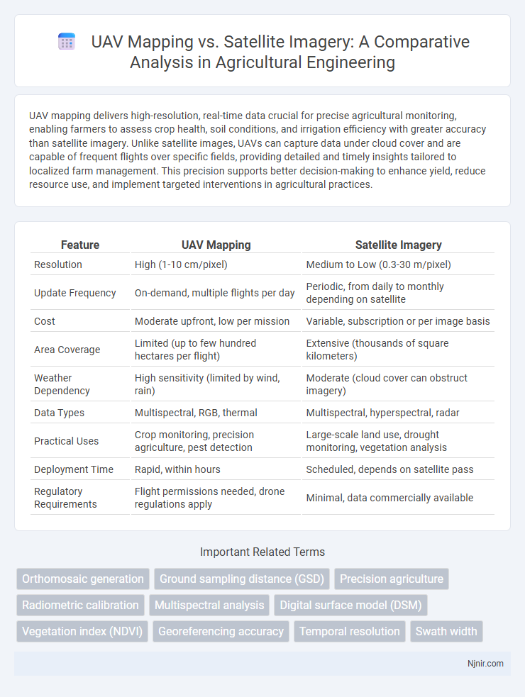
Table of Comparison
| Feature | UAV Mapping | Satellite Imagery |
|---|---|---|
| Resolution | High (1-10 cm/pixel) | Medium to Low (0.3-30 m/pixel) |
| Update Frequency | On-demand, multiple flights per day | Periodic, from daily to monthly depending on satellite |
| Cost | Moderate upfront, low per mission | Variable, subscription or per image basis |
| Area Coverage | Limited (up to few hundred hectares per flight) | Extensive (thousands of square kilometers) |
| Weather Dependency | High sensitivity (limited by wind, rain) | Moderate (cloud cover can obstruct imagery) |
| Data Types | Multispectral, RGB, thermal | Multispectral, hyperspectral, radar |
| Practical Uses | Crop monitoring, precision agriculture, pest detection | Large-scale land use, drought monitoring, vegetation analysis |
| Deployment Time | Rapid, within hours | Scheduled, depends on satellite pass |
| Regulatory Requirements | Flight permissions needed, drone regulations apply | Minimal, data commercially available |
Introduction to UAV Mapping and Satellite Imagery
UAV mapping utilizes drones equipped with high-resolution sensors to capture detailed, customizable aerial data ideal for surveying small to medium areas with centimeter-level accuracy. Satellite imagery provides broad, consistent coverage of large geographic regions but often lacks the fine spatial resolution and adaptability found in UAV data acquisition. Advances in UAV technology are closing gaps in temporal and spatial resolution, making UAV mapping increasingly vital for precision applications like agriculture, construction, and environmental monitoring.
Technology Overview: UAV Mapping
UAV mapping utilizes unmanned aerial vehicles equipped with high-resolution cameras and LiDAR sensors to capture detailed geospatial data with centimeter-level accuracy. This technology enables rapid area coverage, flexible flight planning, and real-time data processing, surpassing the resolution and revisit frequency limitations of traditional satellite imagery. Advanced photogrammetry software transforms UAV-captured images into precise 3D models, orthomosaics, and digital elevation models essential for applications in surveying, agriculture, and construction.
Technology Overview: Satellite Imagery
Satellite imagery utilizes remote sensing technology from orbiting satellites equipped with multispectral and hyperspectral sensors to capture high-resolution images of the Earth's surface across various wavelengths, enabling detailed analysis of land use, vegetation, and environmental changes. These satellites provide broad-area coverage and frequent revisit capabilities, crucial for monitoring large and remote regions with consistent data acquisition. Advances in image processing algorithms and cloud computing enhance the interpretation, classification, and integration of satellite data for applications in agriculture, urban planning, and disaster management.
Spatial Resolution: UAVs vs Satellites
UAV mapping offers superior spatial resolution compared to satellite imagery, often capturing details at centimeters per pixel, while most commercial satellites provide resolution ranging from 30 centimeters to several meters per pixel. This high-resolution capability makes UAVs ideal for detailed site surveys, precision agriculture, and construction monitoring, where fine-scale data is crucial. Satellite imagery covers larger areas but lacks the detailed spatial granularity necessary for tasks demanding close-range observations.
Temporal Resolution and Data Frequency
UAV mapping offers significantly higher temporal resolution compared to satellite imagery, with the ability to capture data multiple times per day, enabling real-time monitoring and timely decision-making. Satellite imagery typically has revisit times ranging from days to weeks, limiting its effectiveness for dynamic environments requiring frequent updates. Enhanced data frequency from UAVs supports applications like precision agriculture and disaster response by providing up-to-date and granular spatial information.
Data Accuracy and Precision in Agricultural Applications
UAV mapping provides significantly higher spatial resolution and data accuracy compared to satellite imagery, enabling precise crop health monitoring and field variability assessment in agricultural applications. The low-altitude flights of UAVs capture fine-grain details with centimeter-level precision, which enhances decision-making for irrigation, fertilization, and pest control. Satellite imagery, while covering larger areas, often suffers from lower resolution and atmospheric interference, limiting its effectiveness for detailed precision agriculture tasks.
Cost Comparison: Initial and Operational Expenses
UAV mapping offers significantly lower initial investment costs compared to satellite imagery, as UAVs require less expensive equipment and software. Operational expenses for UAVs are also reduced due to shorter deployment times and minimal data acquisition fees, unlike satellite imagery which often incurs high licensing and processing costs. Cost efficiency makes UAV mapping ideal for localized projects, while satellite imagery remains suitable for wide-area coverage despite higher expenses.
Accessibility and Deployment Flexibility
UAV mapping offers superior accessibility by capturing high-resolution data in remote or obstructed areas where satellite imagery is often limited by orbital paths and cloud cover. Deployment flexibility with UAVs allows for on-demand, targeted data collection at specific times and locations, unlike satellites that follow predetermined schedules. UAVs can quickly adapt flight paths to changing project needs, enhancing precision and operational efficiency in mapping applications.
Use Cases in Precision Agriculture
UAV mapping provides high-resolution, real-time data critical for monitoring crop health, detecting pest infestations, and managing irrigation efficiently in precision agriculture. Satellite imagery offers broader coverage useful for large-scale field analysis, crop pattern monitoring, and seasonal trend evaluation across extensive farmland. Combining UAV mapping's detailed data with satellite imagery's wide-area perspective enhances decision-making, optimizing yield and resource management.
Challenges and Future Trends in Remote Sensing
UAV mapping faces challenges such as limited flight duration, data processing complexity, and regulatory restrictions, whereas satellite imagery struggles with lower spatial resolution and cloud cover interference. Future trends in remote sensing include integrating UAV and satellite data to enhance spatial and temporal accuracy, advancing AI-driven analytics for real-time data interpretation, and developing autonomous UAV systems for large-scale environmental monitoring. Improvements in sensor technology and regulatory frameworks will further enable precise, cost-effective remote sensing applications across various industries.
Orthomosaic generation
UAV mapping produces higher-resolution orthomosaics with greater positional accuracy and faster update cycles compared to satellite imagery, making it ideal for detailed, localized surveys.
Ground sampling distance (GSD)
UAV mapping offers significantly finer Ground Sampling Distance (GSD), often reaching sub-centimeter resolution compared to satellite imagery's typical GSD ranging from 30 centimeters to several meters, enabling highly detailed and precise spatial data collection.
Precision agriculture
UAV mapping provides higher-resolution, real-time data crucial for precision agriculture by enabling targeted crop monitoring and efficient resource management compared to less detailed, less frequent satellite imagery.
Radiometric calibration
UAV mapping offers superior radiometric calibration accuracy compared to satellite imagery due to its ability to capture high-resolution data under controlled lighting conditions.
Multispectral analysis
UAV mapping offers higher-resolution multispectral analysis with greater flexibility and lower costs compared to satellite imagery for precise environmental monitoring.
Digital surface model (DSM)
UAV mapping generates higher-resolution Digital Surface Models (DSMs) with greater accuracy and detail compared to satellite imagery, enabling precise terrain analysis and feature detection.
Vegetation index (NDVI)
UAV mapping provides higher-resolution NDVI data than satellite imagery, enabling more precise monitoring of vegetation health and stress at localized scales.
Georeferencing accuracy
UAV mapping typically offers higher georeferencing accuracy than satellite imagery due to lower altitude flights and the use of ground control points, enabling centimeter-level precision compared to the meter-level accuracy of most satellite images.
Temporal resolution
UAV mapping offers superior temporal resolution compared to satellite imagery by enabling more frequent and flexible data capture for real-time monitoring and rapid change detection.
Swath width
UAV mapping offers narrower swath widths of typically 100-300 meters compared to satellite imagery swath widths spanning several kilometers, enabling higher-resolution and more detailed local area surveys.
UAV mapping vs Satellite imagery Infographic