Ground penetrating radar (GPR) provides high-resolution imaging of subsurface structures by emitting electromagnetic waves, making it ideal for detecting utilities and voids in civil engineering projects. Electrical resistivity testing measures the soil's resistance to electrical current, offering valuable data on subsurface material properties such as moisture content and stratigraphy. Combining GPR and electrical resistivity enhances site characterization by delivering complementary insights into both structural features and geotechnical conditions.
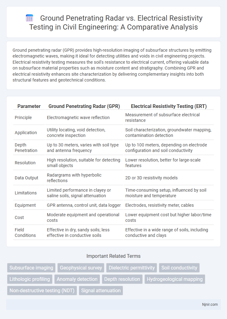
Table of Comparison
| Parameter | Ground Penetrating Radar (GPR) | Electrical Resistivity Testing (ERT) |
|---|---|---|
| Principle | Electromagnetic wave reflection | Measurement of subsurface electrical resistance |
| Application | Utility locating, void detection, concrete inspection | Soil characterization, groundwater mapping, contamination detection |
| Depth Penetration | Up to 30 meters, varies with soil type and antenna frequency | Up to 100 meters, depending on electrode configuration and soil conductivity |
| Resolution | High resolution, suitable for detecting small objects | Lower resolution, better for large-scale features |
| Data Output | Radargrams with hyperbolic reflections | 2D or 3D resistivity models |
| Limitations | Limited performance in clayey or saline soils, signal attenuation | Time-consuming setup, influenced by soil moisture and temperature |
| Equipment | GPR antenna, control unit, data logger | Electrodes, resistivity meter, cables |
| Cost | Moderate equipment and operational costs | Lower equipment cost but higher labor/time costs |
| Field Conditions | Effective in dry, sandy soils; less effective in conductive soils | Effective in a wide range of soils, including conductive and clays |
Introduction to Subsurface Investigation Techniques
Ground penetrating radar (GPR) and electrical resistivity testing are critical subsurface investigation techniques used in geotechnical, environmental, and archaeological surveys. GPR employs high-frequency electromagnetic waves to detect and map subsurface structures by measuring reflected signals, offering high-resolution imaging of shallow to moderate depths. Electrical resistivity testing measures the soil's resistance to electric current flow, providing valuable data on subsurface materials and fluid content, especially useful for detecting groundwater, soil contamination, and stratigraphy variations.
Overview of Ground Penetrating Radar (GPR)
Ground Penetrating Radar (GPR) operates by emitting high-frequency radio waves into the subsurface and detecting reflected signals from subsurface structures, providing high-resolution images of buried objects, voids, and layers. GPR is effective in detecting non-metallic and metallic objects, void spaces, and changes in material properties, making it versatile for utility mapping, archaeology, and geotechnical investigations. Compared to electrical resistivity testing, GPR delivers faster data acquisition and more detailed spatial resolution but has limited effectiveness in highly conductive soils such as clays.
Fundamentals of Electrical Resistivity Testing
Electrical resistivity testing measures subsurface resistivity variations by injecting an electrical current into the ground and recording potential differences, providing detailed information on soil and rock properties. This method relies on the contrast in resistivity caused by factors such as moisture content, porosity, and mineral composition, enabling the detection of groundwater, contamination, or voids. Unlike ground penetrating radar, which uses electromagnetic waves and is influenced by material dielectric permittivity, electrical resistivity testing offers deeper penetration in conductive soils and better resolution of resistivity anomalies.
Working Principles: GPR vs Electrical Resistivity
Ground penetrating radar (GPR) operates by emitting high-frequency electromagnetic waves into the subsurface, with reflected signals indicating changes in material properties or the presence of objects. Electrical resistivity testing measures the subsurface electrical resistance by injecting current between electrodes and analyzing voltage differences to map variations in soil or rock conductivity. GPR excels in detecting non-conductive materials and precise depth imaging, while electrical resistivity is effective for identifying moisture content, porosity, and mineralization through conductivity contrasts.
Material Detection Capabilities
Ground penetrating radar (GPR) excels in detecting non-metallic and metallic objects, voids, and changes in material composition by emitting high-frequency radio waves and analyzing their reflections. Electrical resistivity testing measures subsurface resistivity variations, effectively identifying moisture content, clay layers, and groundwater but has limited resolution for small or shallow objects. GPR provides higher spatial resolution for detailed imaging of buried materials, while resistivity testing offers broader subsurface characterization based on electrical properties.
Depth Penetration and Resolution Comparison
Ground penetrating radar (GPR) typically offers higher resolution imaging with depth penetration ranging from 1 to 30 meters depending on soil conditions and antenna frequency, making it ideal for detecting shallow subsurface features. Electrical resistivity testing (ERT) provides greater depth penetration, often exceeding 100 meters in favorable geological conditions, but with lower spatial resolution compared to GPR. The choice between GPR and ERT depends on balancing the need for detailed shallow imaging versus deeper subsurface characterization.
Applications in Civil Engineering Projects
Ground penetrating radar (GPR) excels in detecting subsurface utilities, voids, and rebar positioning within concrete structures, making it ideal for concrete inspection and underground utility mapping in civil engineering projects. Electrical resistivity testing (ERT) is effective for characterizing soil stratigraphy, groundwater contamination, and identifying zones of differing moisture content, crucial in foundation design and geotechnical site investigations. Combining GPR and ERT enhances subsurface imaging accuracy, improving safety and efficiency in infrastructure development and maintenance.
Advantages and Limitations of Each Method
Ground penetrating radar (GPR) offers high-resolution imaging and rapid data acquisition, making it ideal for detecting shallow subsurface features and utilities, but its effectiveness diminishes in clay-rich or conductive soils. Electrical resistivity testing (ERT) provides deeper penetration and is capable of mapping subsurface variations in moisture content and rock properties, yet it requires longer survey times and complex data interpretation. GPR excels in fine stratigraphic detail while ERT is better suited for large-scale geological investigations and groundwater studies.
Factors Influencing Technique Selection
Ground penetrating radar (GPR) effectiveness depends on soil composition, moisture content, and depth of the target, excelling in dry, sandy soils with shallow to moderate depths. Electrical resistivity testing (ERT) performs better in clay-rich or conductive soils where GPR signals may attenuate, providing detailed subsurface resistivity profiles at greater depths. Site-specific conditions such as soil heterogeneity, target size, and the presence of buried utilities play critical roles in determining the optimal geophysical method.
Future Trends in Subsurface Imaging Technology
Ground penetrating radar (GPR) and electrical resistivity testing (ERT) continue to evolve with advancements in sensor technology and data processing algorithms, enhancing resolution and depth penetration in subsurface imaging. Integration of machine learning and real-time 3D visualization is transforming both techniques, enabling faster and more accurate detection of underground anomalies such as utilities, voids, and contaminants. Future trends emphasize hybrid systems combining GPR and ERT data to leverage complementary strengths, improving subsurface characterization for applications in geotechnical engineering, environmental monitoring, and archaeological exploration.
Subsurface imaging
Ground penetrating radar provides high-resolution subsurface imaging by detecting reflected electromagnetic waves, while electrical resistivity testing maps subsurface features based on variations in soil resistivity for detailed geological characterization.
Geophysical survey
Ground penetrating radar (GPR) provides high-resolution subsurface imaging using electromagnetic waves, while electrical resistivity testing measures soil and rock resistivity to detect variations in moisture content and composition during geophysical surveys.
Dielectric permittivity
Ground penetrating radar utilizes dielectric permittivity to measure subsurface material properties by detecting electromagnetic wave reflections, whereas electrical resistivity testing primarily assesses subsurface resistivity without directly measuring dielectric permittivity.
Soil conductivity
Ground penetrating radar provides high-resolution imaging of subsurface structures while electrical resistivity testing precisely measures soil conductivity variations to differentiate between moisture content and material composition.
Lithologic profiling
Ground penetrating radar provides high-resolution lithologic profiling by detecting subsurface dielectric contrasts, while electrical resistivity testing maps lithologic variations based on soil and rock electrical conductivity differences.
Anomaly detection
Ground penetrating radar (GPR) and electrical resistivity testing (ERT) both detect subsurface anomalies, with GPR excelling in high-resolution imaging of shallow, non-conductive materials and ERT providing deeper penetration and better differentiation of resistive versus conductive anomalies in heterogeneous soils.
Depth resolution
Ground penetrating radar provides higher depth resolution compared to electrical resistivity testing, enabling more detailed subsurface imaging at shallow to moderate depths.
Hydrogeological mapping
Ground penetrating radar provides high-resolution subsurface imaging ideal for detecting shallow aquifers, while electrical resistivity testing offers deeper penetration for detailed hydrogeological mapping of groundwater flow and lithological variations.
Non-destructive testing (NDT)
Ground penetrating radar (GPR) provides high-resolution imaging of subsurface features through electromagnetic wave reflections, while electrical resistivity testing measures soil and material resistivity to map subsurface variations, both serving as essential non-destructive testing (NDT) methods for geotechnical and structural evaluations.
Signal attenuation
Signal attenuation in ground penetrating radar is significantly higher in conductive or moist soils compared to electrical resistivity testing, which experiences less signal loss in such conditions, making resistivity more effective for subsurface imaging in high-attenuation environments.
Ground penetrating radar vs electrical resistivity testing Infographic