Laser scanning offers high-precision 3D data capture with rapid acquisition times, making it ideal for detailed civil engineering surveys and structural assessments. Photogrammetry provides cost-effective, versatile mapping using standard cameras, suitable for large-area mapping and terrain modeling. Combining both technologies enhances accuracy and efficiency in complex project environments.
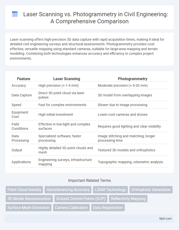
Table of Comparison
| Feature | Laser Scanning | Photogrammetry |
|---|---|---|
| Accuracy | High precision (+-1-5 mm) | Moderate precision (+-5-30 mm) |
| Data Capture | Direct 3D point cloud via laser pulses | 3D model from overlapping images |
| Speed | Fast for complex environments | Slower due to image processing |
| Equipment Cost | High initial investment | Lower-cost cameras and drones |
| Field Conditions | Effective in low-light and complex surfaces | Requires good lighting and clear visibility |
| Data Processing | Specialized software, faster processing | Image stitching and matching, longer processing time |
| Output | Highly detailed 3D point clouds and mesh | Textured 3D models and orthophotos |
| Applications | Engineering surveys, infrastructure mapping | Topographic mapping, volumetric analysis |
Introduction to Laser Scanning and Photogrammetry
Laser scanning uses LiDAR technology to capture precise 3D measurements by emitting laser pulses and recording their reflections, generating highly accurate point clouds ideal for detailed topographic mapping and construction monitoring. Photogrammetry employs high-resolution imagery from cameras or drones to create 3D models through image overlap and triangulation, offering cost-effective and flexible solutions for large area surveys and visual documentation. Both techniques provide critical spatial data, but laser scanning excels in accuracy and penetration in complex environments, while photogrammetry delivers quicker data acquisition with extensive color information.
Principles and Technologies Behind Each Method
Laser scanning employs LiDAR technology to emit laser pulses that measure distances by calculating the time it takes for the light to reflect back, generating precise 3D point clouds of surfaces. Photogrammetry uses overlapping photographs taken from multiple angles to reconstruct 3D models by analyzing common features and calculating spatial positions through triangulation algorithms. Both methods rely on advanced sensors and software, but laser scanning captures data through active light emission, while photogrammetry depends on passive image acquisition for spatial analysis.
Accuracy and Precision Comparison
Laser scanning offers higher accuracy and precision than photogrammetry, with typical spatial resolution reaching sub-millimeter levels, making it ideal for detailed engineering and construction applications. Photogrammetry accuracy depends heavily on image quality, camera calibration, and environmental conditions, generally resulting in centimeter-level precision suitable for broader mapping tasks. While laser scanning captures dense point clouds directly from surfaces, photogrammetry relies on image overlap and feature matching, affecting its precision in complex or feature-poor environments.
Workflow and Data Processing Differences
Laser scanning captures precise 3D point clouds by emitting laser pulses and measuring their return times, enabling rapid data collection with high spatial accuracy, while photogrammetry relies on overlapping images to reconstruct surfaces through complex image processing algorithms. Laser scanning workflows typically involve direct data acquisition followed by point cloud registration and cleaning, whereas photogrammetry requires extensive pre-processing such as image alignment, feature matching, and dense point cloud generation through structure-from-motion and multi-view stereo techniques. Data processing for laser scanning emphasizes noise filtering and point cloud meshing, whereas photogrammetry demands computationally intensive image analysis and texture mapping to produce photorealistic 3D models.
Equipment and Software Requirements
Laser scanning requires specialized LiDAR equipment capable of capturing high-density point clouds with precise distance measurements, often supported by dedicated software like Faro Scene or Leica Cyclone for data processing and 3D modeling. Photogrammetry relies on high-resolution cameras and drones for capturing multiple overlapping images, which are processed using software such as Agisoft Metashape or Pix4D to generate 3D models through image stitching and point cloud creation. The hardware demands for laser scanners are typically higher cost and complexity, whereas photogrammetry can be more accessible with standard photographic equipment but necessitates powerful computing resources for image processing.
Field Applications in Civil Engineering
Laser scanning offers high-precision 3D data collection ideal for complex civil engineering structures such as bridges, tunnels, and retaining walls, enabling accurate as-built documentation and deformation analysis. Photogrammetry provides cost-effective and rapid site surveying for large-scale topographic mapping and volumetric calculations, benefiting road construction, earthworks, and site monitoring with drone-based imagery. Both technologies enhance project efficiency and accuracy, with laser scanning excelling in detailed structural assessments and photogrammetry optimizing surface data acquisition over extensive areas.
Cost-Benefit Analysis
Laser scanning offers highly accurate 3D data acquisition but involves significant upfront equipment costs and specialized training expenses. Photogrammetry provides a cost-effective alternative with scalable solutions using standard cameras and software, ideal for large area mapping but may require extensive post-processing to achieve precision. Evaluating project scope, accuracy requirements, and budget constraints is crucial to determine the most cost-efficient method between laser scanning and photogrammetry.
Limitations and Challenges
Laser scanning faces challenges with high equipment costs, limited effectiveness in capturing texture details, and difficulties in scanning reflective or transparent surfaces. Photogrammetry struggles with inconsistent lighting conditions, occlusions, and requires extensive image overlap for accurate 3D reconstruction. Both methods encounter limitations in processing time and data management when handling large-scale or complex environments.
Integration with BIM and GIS
Laser scanning provides high-precision 3D point clouds that integrate seamlessly with BIM and GIS platforms, enhancing spatial accuracy and detail for modeling and analysis. Photogrammetry generates textured 3D models from images, offering cost-effective data that complements BIM workflows and GIS mapping but with less geometric precision than laser scanning. Combining both technologies leverages laser scanning's accuracy and photogrammetry's visual richness, optimizing integration for comprehensive BIM and GIS project applications.
Future Trends and Innovations
Laser scanning technology is advancing rapidly with innovations such as compact, high-resolution LiDAR sensors and real-time 3D data processing, enhancing speed and accuracy in surveying applications. Photogrammetry is evolving through AI-driven image analysis and drone integration, enabling more efficient large-scale mapping and automated feature extraction. Emerging hybrid systems combining laser scanning and photogrammetry capitalize on the strengths of both, delivering unparalleled spatial data quality and versatility.
Point Cloud Density
Laser scanning produces higher point cloud density than photogrammetry, enabling more detailed and accurate 3D models for complex surfaces.
Georeferencing Accuracy
Laser scanning achieves higher georeferencing accuracy than photogrammetry due to its precise distance measurements and direct geospatial data capture.
LiDAR Technology
LiDAR technology offers superior accuracy and real-time 3D mapping compared to photogrammetry in laser scanning applications.
Orthophoto Generation
Laser scanning provides highly accurate, direct 3D point clouds for orthophoto generation, while photogrammetry relies on overlapping images and image-processing algorithms to create orthophotos with detailed color information but potentially lower geometric precision.
3D Model Reconstruction
Laser scanning provides high-precision 3D model reconstruction with detailed surface geometry, while photogrammetry offers cost-effective, scalable 3D models by reconstructing surfaces from overlapping images.
Ground Control Points (GCP)
Laser scanning requires fewer Ground Control Points (GCPs) than photogrammetry due to its high-accuracy direct distance measurements, making GCP placement less critical for achieving precise georeferencing.
Reflectivity Mapping
Laser scanning provides precise reflectivity mapping by measuring the intensity of returned laser signals, whereas photogrammetry estimates reflectivity indirectly through pixel color variations in images.
Surface Mesh Extraction
Laser scanning provides highly accurate 3D surface mesh extraction with dense point clouds and precise depth measurements, while photogrammetry offers cost-effective mesh generation using overlapping 2D images but may produce less detailed surfaces in complex geometries.
Camera Calibration
Camera calibration for laser scanning involves precise alignment of laser sensors to spatial coordinates, while photogrammetry relies on calibrating camera parameters like focal length and lens distortion to ensure accurate 3D reconstruction from images.
Data Registration
Laser scanning offers higher accuracy and faster automatic data registration compared to photogrammetry, which relies heavily on manual alignment and feature matching.
laser scanning vs photogrammetry Infographic