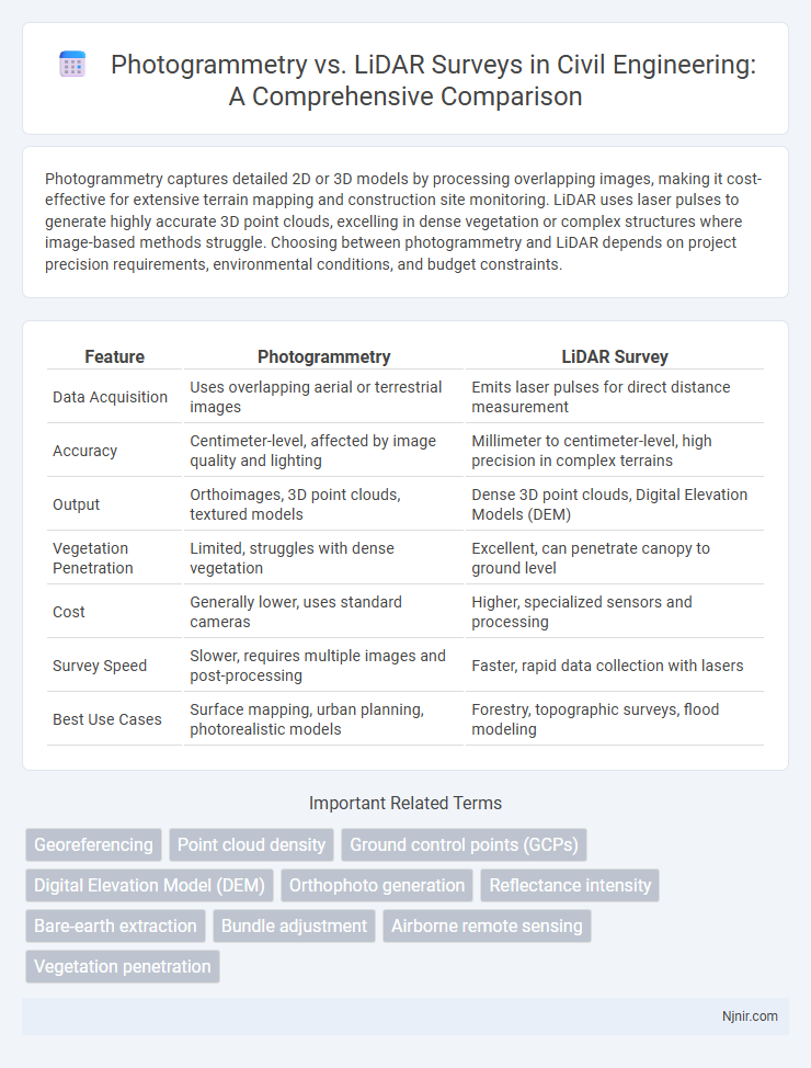
Photogrammetry captures detailed 2D or 3D models by processing overlapping images, making it cost-effective for extensive terrain mapping and construction site monitoring. LiDAR uses laser pulses to generate highly accurate 3D point clouds, excelling in dense vegetation or complex structures where image-based methods struggle. Choosing between photogrammetry and LiDAR depends on project precision requirements, environmental conditions, and budget constraints.
Table of Comparison
| Feature | Photogrammetry | LiDAR Survey |
|---|---|---|
| Data Acquisition | Uses overlapping aerial or terrestrial images | Emits laser pulses for direct distance measurement |
| Accuracy | Centimeter-level, affected by image quality and lighting | Millimeter to centimeter-level, high precision in complex terrains |
| Output | Orthoimages, 3D point clouds, textured models | Dense 3D point clouds, Digital Elevation Models (DEM) |
| Vegetation Penetration | Limited, struggles with dense vegetation | Excellent, can penetrate canopy to ground level |
| Cost | Generally lower, uses standard cameras | Higher, specialized sensors and processing |
| Survey Speed | Slower, requires multiple images and post-processing | Faster, rapid data collection with lasers |
| Best Use Cases | Surface mapping, urban planning, photorealistic models | Forestry, topographic surveys, flood modeling |
Introduction to Photogrammetry and LiDAR in Civil Engineering
Photogrammetry in civil engineering utilizes aerial or ground-based imagery to create detailed 3D models by measuring distances between objects, enabling accurate mapping of construction sites and infrastructure. LiDAR surveys employ laser pulses to generate high-resolution point clouds with precise elevation data, offering superior accuracy for topographic analysis, terrain modeling, and detecting subtle surface variations. Both technologies support civil engineering projects by improving site assessment, design precision, and project monitoring, with photogrammetry excelling in texture and color information while LiDAR provides exceptional spatial resolution and penetration through vegetation.
Fundamental Principles of Photogrammetry
Photogrammetry relies on capturing overlapping images from multiple angles to create precise 3D models by analyzing parallax differences between corresponding points in photographs. It uses principles of triangulation and image correlation to measure spatial dimensions and reconstruct surfaces accurately. This method depends heavily on high-resolution imagery and precise camera calibration to ensure geometric accuracy in surveying applications.
Core Concepts of LiDAR Technology
LiDAR technology uses laser pulses to measure distances accurately by calculating the time it takes for light to reflect off surfaces and return to the sensor, enabling the creation of precise 3D models. This method excels in capturing detailed elevation data and penetrating vegetation cover, which photogrammetry struggles with due to its reliance on photographic images. The core components of LiDAR include the laser scanner, GPS, and an inertial measurement unit (IMU), which work together to provide high-resolution spatial data crucial for topographic mapping and terrain analysis.
Data Acquisition Methods: Photogrammetry vs LiDAR
Photogrammetry captures data by using overlapping photographs taken from multiple angles, relying on high-resolution cameras and GPS for precise positioning. LiDAR survey employs laser pulses emitted from airborne or terrestrial scanners to measure distances directly, creating dense and accurate 3D point clouds. While photogrammetry depends on ambient light and texture for detail, LiDAR operates effectively in varying light conditions, offering superior accuracy in complex terrains and vegetation.
Accuracy and Precision Comparison
Photogrammetry offers high-resolution imagery with accuracy typically ranging from a few centimeters to decimeters depending on flight altitude and ground control points, while LiDAR provides superior precision with centimeter-level accuracy by directly measuring distances using laser pulses. LiDAR excels in dense vegetation or complex terrain where photogrammetry's accuracy diminishes due to occlusions and lighting conditions. Overall, LiDAR delivers more consistent and precise spatial data, making it the preferred choice for applications requiring detailed topographic accuracy and fine-scale measurements.
Applications in Civil Engineering Projects
Photogrammetry and LiDAR surveys serve critical roles in civil engineering projects by providing accurate topographic data and 3D models for site analysis, design, and construction monitoring. Photogrammetry is widely used for large-scale mapping and volumetric calculations due to its cost-effectiveness and capability to capture high-resolution imagery, while LiDAR excels in generating precise elevation data and penetrating vegetation or complex surfaces for detailed terrain modeling. Projects such as road design, bridge construction, and land surveying benefit from integrating both technologies to optimize planning accuracy and enhance project outcomes.
Cost Analysis: Photogrammetry and LiDAR
Photogrammetry offers a cost-effective surveying solution by utilizing standard digital cameras and drones, resulting in lower equipment and operational expenses compared to LiDAR systems, which require specialized, high-priced laser sensors. While LiDAR delivers superior accuracy and penetrates dense vegetation, its initial investment and maintenance costs are substantially higher, often limiting its use to projects demanding high precision. The overall cost-efficiency of photogrammetry makes it ideal for large-area mapping with moderate accuracy, whereas LiDAR is preferred for detailed topographic surveys where budget permits advanced technology deployment.
Data Processing and Workflow Differences
Photogrammetry uses overlapping images to create 3D models through structure-from-motion algorithms, requiring extensive image alignment and dense point cloud generation, which can be computationally intensive but produces high-resolution textures. LiDAR surveys capture direct distance measurements using laser pulses, generating precise point clouds quickly with less post-processing needed for alignment, resulting in faster creation of accurate terrain and object models. Workflow differences include photogrammetry's reliance on high-quality images and longer processing times versus LiDAR's streamlined data capture and rapid processing suited for complex environments and dense vegetation.
Advantages and Limitations of Each Method
Photogrammetry offers high-resolution, color-accurate 3D models ideal for detailed surface analysis and is cost-effective for large-scale projects using UAVs, but it struggles with low-light conditions and dense vegetation. LiDAR provides precise distance measurements with superior performance in complex terrains, penetrating forest canopies and capturing accurate elevation data, though it tends to be more expensive and requires specialized equipment. Each method's effectiveness depends on project requirements such as detail resolution, environmental conditions, and budget constraints.
Future Trends in Surveying Technologies
Emerging trends in surveying technologies prioritize integrating photogrammetry and LiDAR for enhanced spatial accuracy and efficiency. Advances in drone technology and AI-driven data processing enable real-time 3D mapping, facilitating complex terrain analysis and infrastructure monitoring. Future developments emphasize multi-sensor fusion, increased automation, and cloud-based platforms to streamline surveying workflows and improve data accessibility.
Georeferencing
Photogrammetry georeferences survey data by matching overlapping images to ground control points, while LiDAR directly records precise 3D coordinates using laser pulses for higher geospatial accuracy.
Point cloud density
LiDAR surveys typically generate higher point cloud density than photogrammetry, enabling more detailed and accurate 3D models for complex terrain analysis.
Ground control points (GCPs)
Photogrammetry relies heavily on accurately placed Ground Control Points (GCPs) to enhance spatial accuracy, whereas LiDAR surveys often require fewer GCPs due to direct distance measurements using laser pulses.
Digital Elevation Model (DEM)
Photogrammetry produces high-resolution Digital Elevation Models (DEMs) from aerial images ideal for detailed surface analysis, while LiDAR surveys generate highly accurate DEMs with precise elevation data by measuring laser returns, excelling in dense vegetation or complex terrain mapping.
Orthophoto generation
Photogrammetry generates orthophotos by stitching overlapping aerial images using software algorithms, while LiDAR produces orthophotos by mapping precise ground points with laser pulses, offering higher accuracy in complex terrain.
Reflectance intensity
Photogrammetry captures reflectance intensity indirectly through image brightness variations, while LiDAR surveys measure reflectance intensity directly by recording the strength of laser return signals for precise surface characterization.
Bare-earth extraction
LiDAR survey outperforms photogrammetry in bare-earth extraction by directly capturing ground elevations through laser pulses, enabling precise terrain modeling even under dense vegetation, whereas photogrammetry relies on surface images that often include vegetation and structures, complicating bare-earth isolation.
Bundle adjustment
Bundle adjustment in photogrammetry refines 3D reconstructions by minimizing reprojection errors through simultaneous optimization of camera parameters and 3D point coordinates, contrasting with LiDAR surveys that directly capture precise distance measurements without requiring such geometric optimization.
Airborne remote sensing
Airborne LiDAR survey provides higher accuracy and penetration of dense vegetation compared to photogrammetry, which relies on overlapping images for 3D terrain modeling.
Vegetation penetration
LiDAR survey penetrates dense vegetation more effectively than photogrammetry by using laser pulses to capture ground details beneath canopy cover.
Photogrammetry vs LiDAR survey Infographic