Drone surveying offers significantly faster data collection and higher-resolution imagery compared to traditional surveying methods, enhancing project efficiency in civil engineering. It reduces the need for manual measurements and mitigates safety risks associated with difficult terrain or hazardous sites. The integration of UAV technology streamlines mapping, topographical analysis, and progress monitoring, providing real-time data that supports more accurate decision-making.
Table of Comparison
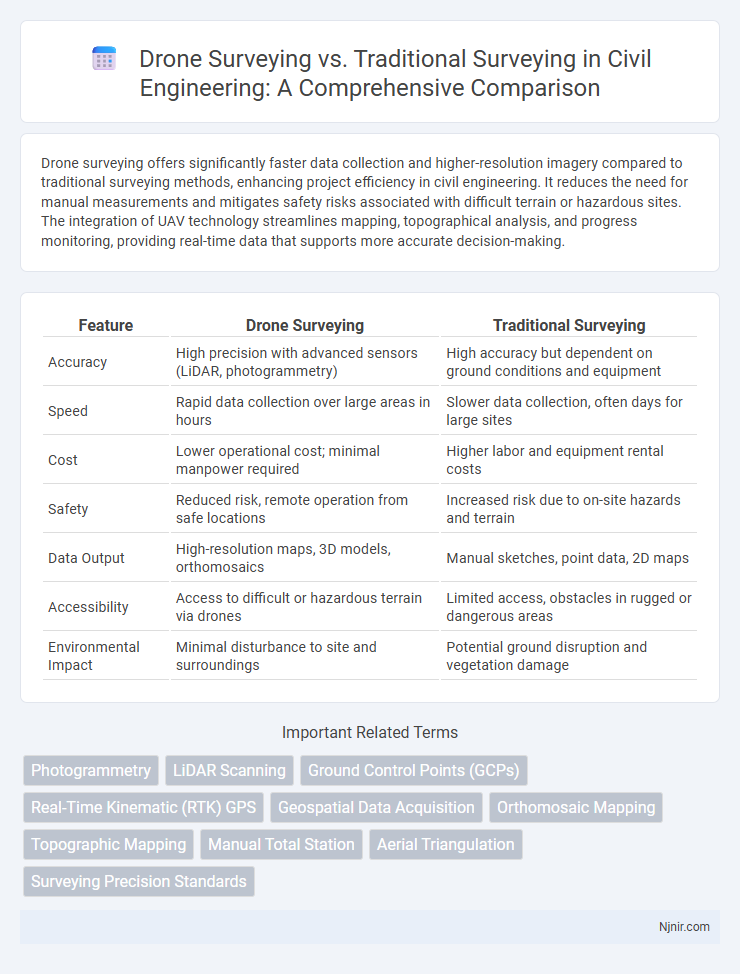
| Feature | Drone Surveying | Traditional Surveying |
|---|---|---|
| Accuracy | High precision with advanced sensors (LiDAR, photogrammetry) | High accuracy but dependent on ground conditions and equipment |
| Speed | Rapid data collection over large areas in hours | Slower data collection, often days for large sites |
| Cost | Lower operational cost; minimal manpower required | Higher labor and equipment rental costs |
| Safety | Reduced risk, remote operation from safe locations | Increased risk due to on-site hazards and terrain |
| Data Output | High-resolution maps, 3D models, orthomosaics | Manual sketches, point data, 2D maps |
| Accessibility | Access to difficult or hazardous terrain via drones | Limited access, obstacles in rugged or dangerous areas |
| Environmental Impact | Minimal disturbance to site and surroundings | Potential ground disruption and vegetation damage |
Introduction to Surveying Methods in Civil Engineering
Drone surveying in civil engineering leverages unmanned aerial vehicles equipped with high-resolution cameras and LiDAR sensors to rapidly capture detailed topographic data, improving accuracy and efficiency compared to traditional ground-based methods like total stations and GPS surveys. This modern approach minimizes human error, reduces project timelines, and enhances safety by accessing difficult terrain without physical presence. While traditional surveying remains essential for precise measurements in confined spaces, drone surveying offers scalable and cost-effective solutions for large-scale land assessments and infrastructure planning.
Overview of Drone Surveying Technology
Drone surveying technology utilizes unmanned aerial vehicles equipped with high-resolution cameras and LiDAR sensors to capture accurate spatial data quickly and efficiently. This approach enables rapid data collection over large or difficult terrain, generating detailed 3D maps and models that surpass the speed and safety of traditional surveying methods. Advanced software processes the captured imagery to produce precise topographic surveys, making drone surveying an innovative solution for construction, agriculture, and environmental monitoring.
Traditional Surveying Techniques Explained
Traditional surveying techniques involve methods such as total stations, theodolites, and GPS equipment to measure land and topographical features with high accuracy. These techniques rely on manual data collection and physical access to survey sites, often requiring extensive labor and time for complex terrains. Despite advancements in drone surveying, traditional methods remain essential for projects demanding precise control points and legal boundary verification.
Accuracy Comparison: Drones vs. Traditional Surveying
Drone surveying offers high accuracy through advanced GPS and photogrammetry, achieving centimeter-level precision ideal for large or hard-to-reach areas. Traditional surveying methods rely on total stations and theodolites, providing excellent point-specific accuracy but often require more time and are limited by terrain accessibility. Despite its rapid data collection, drone surveying may be slightly less accurate in complex environments, while traditional surveys excel in detailed, controlled measurements.
Time Efficiency and Project Turnaround
Drone surveying significantly reduces data collection time by capturing large areas with high-resolution imagery in a fraction of the hours required by traditional surveying methods. The rapid data acquisition coupled with advanced processing software accelerates project turnaround, enabling faster decision-making and project milestones. Traditional surveying, reliant on manual measurements and ground crews, often extends timelines due to physical constraints and data integration delays.
Cost Analysis of Surveying Methods
Drone surveying significantly reduces labor and equipment costs compared to traditional surveying methods by minimizing the need for extensive field crews and manual data collection. The rapid data acquisition and processing capabilities of drones cut project timelines, leading to lower overall operational expenses. Despite initial investment in drone technology, the long-term savings and improved efficiency make drone surveying a cost-effective alternative for various surveying applications.
Safety Considerations in Surveying Operations
Drone surveying enhances safety by minimizing the need for personnel to access hazardous or difficult terrains such as steep slopes, dense forests, and unstable structures. Traditional surveying often requires surveyors to be physically present in potentially dangerous environments, increasing risks of falls, accidents, and exposure to harmful elements. Implementing drone technology reduces on-site human exposure, thereby lowering the incidence of workplace injuries and improving overall safety in surveying operations.
Data Collection and Processing Capabilities
Drone surveying significantly enhances data collection by capturing high-resolution aerial imagery and 3D mapping data rapidly over large areas, outperforming traditional surveying methods that rely on manual measurements and limited ground-based instruments. Advanced photogrammetry software processes drone-captured images to generate accurate, georeferenced models and topographic maps with increased detail and precision. The efficiency of drone data processing reduces time and labor costs, enabling faster project completion and more timely decision-making compared to conventional surveying workflows.
Environmental Impact and Accessibility
Drone surveying significantly reduces environmental impact by minimizing the need for extensive ground disturbance and heavy machinery, preserving natural habitats and ecosystems. It allows access to difficult or hazardous terrains such as wetlands, mountains, and unstable ground without physical intrusion, enhancing survey efficiency and safety. Traditional surveying often requires more invasive methods and limited accessibility, potentially causing soil compaction and vegetation damage in sensitive areas.
Future Trends in Civil Engineering Surveying
Drone surveying offers unprecedented speed and accuracy in collecting topographic data, significantly reducing project timelines compared to traditional surveying methods. Integration of AI and machine learning in drone data processing is enabling real-time analysis and predictive modeling, enhancing decision-making in civil engineering projects. The future of civil engineering surveying increasingly relies on autonomous drone fleets combined with advanced geospatial analytics to improve site management and infrastructure monitoring.
Photogrammetry
Drone surveying using photogrammetry captures high-resolution aerial images for efficient 3D mapping, offering faster data collection and enhanced accuracy compared to traditional ground-based surveying methods.
LiDAR Scanning
Drone surveying with LiDAR scanning offers faster data collection, higher accuracy, and improved terrain mapping compared to traditional surveying methods.
Ground Control Points (GCPs)
Drone surveying requires fewer Ground Control Points (GCPs) than traditional surveying, enhancing efficiency and accuracy in mapping large or inaccessible areas.
Real-Time Kinematic (RTK) GPS
Drone surveying equipped with Real-Time Kinematic (RTK) GPS provides centimeter-level accuracy and faster data collection compared to traditional surveying methods relying on conventional GPS or total stations.
Geospatial Data Acquisition
Drone surveying accelerates geospatial data acquisition by capturing high-resolution aerial imagery and generating precise 3D maps, outperforming traditional surveying methods in speed, detail, and accessibility of difficult terrains.
Orthomosaic Mapping
Drone surveying generates high-resolution orthomosaic maps faster and more cost-effectively than traditional surveying methods, enhancing precision and reducing field time.
Topographic Mapping
Drone surveying provides faster, more accurate topographic mapping with high-resolution 3D data compared to conventional traditional surveying methods reliant on manual measurements and slower data processing.
Manual Total Station
Drone surveying offers faster data collection and high-resolution 3D mapping compared to traditional manual total station surveying, which is labor-intensive and time-consuming but provides precise point measurements.
Aerial Triangulation
Drone surveying enhances aerial triangulation accuracy and efficiency by capturing high-resolution georeferenced images faster than traditional surveying methods.
Surveying Precision Standards
Drone surveying achieves higher precision standards by capturing high-resolution aerial data with centimeter-level accuracy, surpassing traditional surveying methods that rely on ground-based measurements subject to human and environmental errors.
drone surveying vs traditional surveying Infographic